
Articles | Volume 19, issue 16
https://doi.org/10.5194/amt-19-5457-2026
© Author(s) 2026. This work is distributed under
the Creative Commons Attribution 4.0 License.
the Creative Commons Attribution 4.0 License.
https://doi.org/10.5194/amt-19-5457-2026
© Author(s) 2026. This work is distributed under
the Creative Commons Attribution 4.0 License.
the Creative Commons Attribution 4.0 License.
Research article
| 
25 Aug 2026
Research article |
| 25 Aug 2026
| 25 Aug 2026
A novel segmentation algorithm for the ARM user facility all-sky imagers using machine learning applications

Atmospheric, Climate, and Earth Sciences Division, Pacific Northwest National Laboratory, Richland, WA 99352, USA
Donna M. Flynn
Atmospheric, Climate, and Earth Sciences Division, Pacific Northwest National Laboratory, Richland, WA 99352, USA
Jennifer M. Comstock
Advanced Computing, Mathematics, and Data Division, Pacific Northwest National Laboratory, Richland, WA 99352, USA
Erol L. Cromwell
Advanced Computing, Mathematics, and Data Division, Pacific Northwest National Laboratory, Richland, WA 99352, USA
Brian D. Ermold
Advanced Computing, Mathematics, and Data Division, Pacific Northwest National Laboratory, Richland, WA 99352, USA
Related authors
Fan Mei, Jian Wang, Israel Silber, Nurun Nahar Lata, Gregory W. Vandergrift, Jing Li, Bo Chen, Sarah Brooks, Michael P. Jensen, Min Deng, Damao Zhang, Darielle Dexheimer, Beat Schmid, Zezhen Cheng, and Swarup China
EGUsphere, https://doi.org/10.5194/egusphere-2026-2245, https://doi.org/10.5194/egusphere-2026-2245, 2026
Short summary
Short summary
Tethered balloon measurements from 149 flights during DOE ARM TRACER over Houston characterize vertical aerosol and CCN structure. Back-trajectory clustering identifies three air mass types—marine, mixed, and urban—with distinct profiles shaped by boundary-layer depth and coastal circulations. A case study shows mesoscale advection simultaneously transforms thermodynamic and aerosol conditions, underscoring the need to constrain meteorology before attributing cloud changes to aerosol forcing.
Timothy W. Juliano, Florian Tornow, Ann M. Fridlind, Andrew S. Ackerman, Gregory S. Elsaesser, Bart Geerts, Christian P. Lackner, David Painemal, Israel Silber, Mikhail Ovchinnikov, Gunilla Svensson, Michael Tjernström, Peng Wu, Alejandro Baró Pérez, Peter Bogenschutz, Dmitry Chechin, Kamal Kant Chandrakar, Jan Chylik, Andrey Debolskiy, Rostislav Fadeev, Anu Gupta, Luisa Ickes, Michail Karalis, Martin Köhler, Branko Kosovic, Peter Kuma, Weiwei Li, Evgeny Mortikov, Hugh Morrison, Roel A. J. Neggers, Anna Possner, Tomi Raatikainen, Lea Raillard, Sami Romakkaniemi, Niklas Schnierstein, Shin-ichiro Shima, Nikita Silin, Mikhail Tolstykh, Étienne Vignon, Lulin Xue, Meng Zhang, and Xue Zheng
EGUsphere, https://doi.org/10.5194/egusphere-2026-1237, https://doi.org/10.5194/egusphere-2026-1237, 2026
Short summary
Short summary
Models struggle to capture cloud and precipitation processes and their radiative effects in marine cold-air outbreaks. We use a quasi-Lagrangian framework to compare large-eddy simulation (LES) and single-column model (SCM) output with field and satellite observations. With fixed droplet and ice numbers, LES and SCM agree in liquid-only tests. In mixed-phase conditions, LES plausibly capture cloud thinning and breakup, while SCMs largely remain overcast and thereby miss cloud radiative effects.
Yijia Sun, Ann M. Fridlind, Israel Silber, Nicole Riemer, and Daniel A. Knopf
Geosci. Model Dev., 19, 1581–1617, https://doi.org/10.5194/gmd-19-1581-2026, https://doi.org/10.5194/gmd-19-1581-2026, 2026
Short summary
Short summary
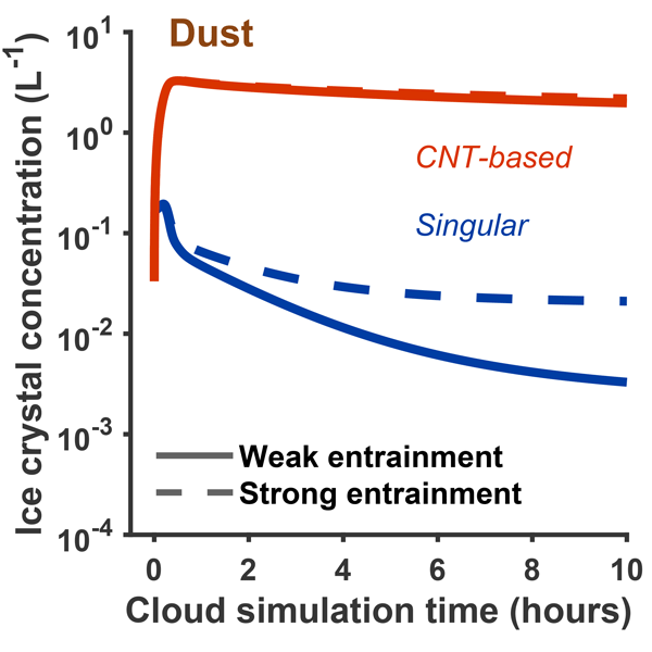
The role of Arctic clouds in the regional climate remains uncertain due to insufficient understanding of the amount of liquid droplets and ice crystals present in these clouds. An aerosol-cloud model is employed to examine the role of different aerosol types and freezing parameterizations on the number of ice crystals. The choice of freezing parameterization significantly changes the number of ice crystals impacting the interpretation of the evolution and warming effect of Arctic clouds.
Israel Silber, Jennifer M. Comstock, Adam K. Theisen, Michael R. Kieburtz, Zeen Zhu, and Jenni Kyrouac
Atmos. Meas. Tech., 19, 485–506, https://doi.org/10.5194/amt-19-485-2026, https://doi.org/10.5194/amt-19-485-2026, 2026
Short summary
Short summary
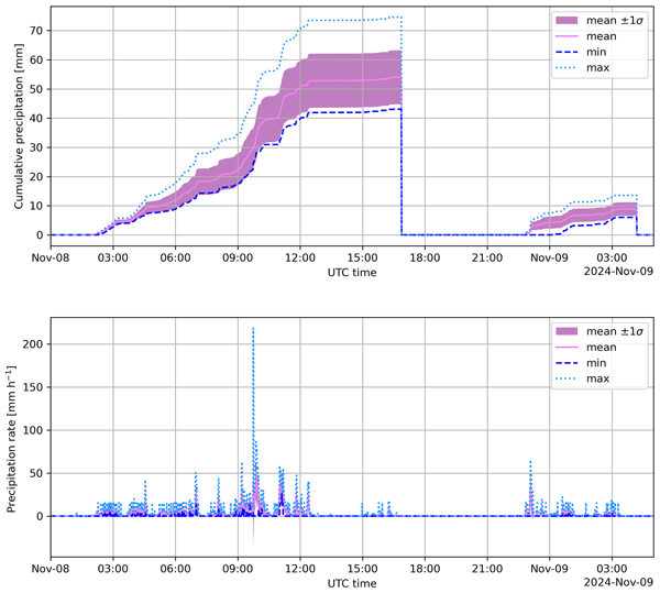
We present PrecipBE, a multi-instrument precipitation event best-estimate data product developed at the Atmospheric Radiation Measurement (ARM) User Facility, providing time series and tabular statistics of events, which could help advance model evaluation and cloud-process studies. We demonstrate PrecipBE's utilization with a brief 30-year trend analysis of ARM Southern Great Plains (SGP) site data, suggesting shorter, less intense events, but rising annual rainfall, driven by rare extremes.
Timothy W. Juliano, Florian Tornow, Ann M. Fridlind, Andrew S. Ackerman, Gregory S. Elsaesser, Bart Geerts, Christian P. Lackner, David Painemal, Israel Silber, Mikhail Ovchinnikov, Gunilla Svensson, Michael Tjernström, Peng Wu, Alejandro Baró Pérez, Peter Bogenschutz, Dmitry Chechin, Kamal Kant Chandrakar, Jan Chylik, Andrey Debolskiy, Rostislav Fadeev, Anu Gupta, Luisa Ickes, Michail Karalis, Martin Köhler, Branko Kosović, Peter Kuma, Weiwei Li, Evgeny Mortikov, Hugh Morrison, Roel A. J. Neggers, Anna Possner, Tomi Raatikainen, Sami Romakkaniemi, Niklas Schnierstein, Shin-ichiro Shima, Nikita Silin, Mikhail Tolstykh, Lulin Xue, Meng Zhang, and Xue Zheng
EGUsphere, https://doi.org/10.5194/egusphere-2025-6217, https://doi.org/10.5194/egusphere-2025-6217, 2026
Preprint archived
Short summary
Short summary
Models struggle to capture cloud and precipitation processes and their radiative effects in marine cold-air outbreaks. We use a quasi-Lagrangian framework to compare large-eddy simulation (LES) and single-column model (SCM) output with field and satellite observations. With fixed droplet and ice numbers, LES and SCM agree in liquid-only tests. In mixed-phase conditions, LES plausibly capture cloud thinning and breakup, while SCMs largely remain overcast and thereby miss cloud radiative effects.
Fan Mei, Qi Zhang, Damao Zhang, Jerome D. Fast, Gourihar Kulkarni, Mikhail S. Pekour, Christopher R. Niedek, Susanne Glienke, Israel Silber, Beat Schmid, Jason M. Tomlinson, Hardeep S. Mehta, Xena Mansoura, Zezhen Cheng, Gregory W. Vandergrift, Nurun Nahar Lata, Swarup China, and Zihua Zhu
Atmos. Chem. Phys., 25, 3425–3444, https://doi.org/10.5194/acp-25-3425-2025, https://doi.org/10.5194/acp-25-3425-2025, 2025
Short summary
Short summary
This study highlights the unique capability of the ArcticShark, an uncrewed aerial system, in measuring vertically resolved atmospheric properties. Data from 32 research flights in 2023 reveal seasonal patterns and correlations with conventional measurements. The consistency and complementarity of in situ and remote sensing methods are highlighted. The study demonstrates the ArcticShark’s versatility in bridging data gaps and improving the understanding of vertical atmospheric structures.
Israel Silber, Jennifer M. Comstock, Michael R. Kieburtz, and Lynn M. Russell
Earth Syst. Sci. Data, 17, 29–42, https://doi.org/10.5194/essd-17-29-2025, https://doi.org/10.5194/essd-17-29-2025, 2025
Short summary
Short summary
We present ARMTRAJ, a set of multipurpose trajectory datasets, which augments cloud, aerosol, and boundary layer studies utilizing the U.S. Department of Energy Atmospheric Radiation Measurement (ARM) user facility data. ARMTRAJ data include ensemble run statistics that enhance consistency and serve as uncertainty metrics for air mass coordinates and state variables. ARMTRAJ will soon become a near real-time product that will accompany past, ongoing, and future ARM deployments.
Abigail S. Williams, Jeramy L. Dedrick, Lynn M. Russell, Florian Tornow, Israel Silber, Ann M. Fridlind, Benjamin Swanson, Paul J. DeMott, Paul Zieger, and Radovan Krejci
Atmos. Chem. Phys., 24, 11791–11805, https://doi.org/10.5194/acp-24-11791-2024, https://doi.org/10.5194/acp-24-11791-2024, 2024
Short summary
Short summary
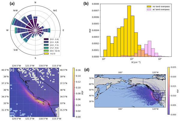
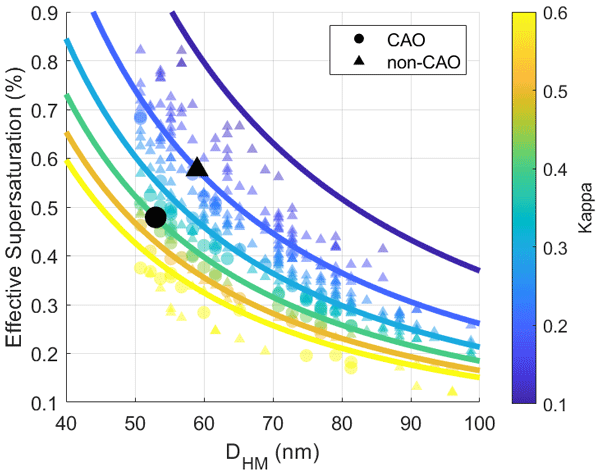
The measured aerosol size distribution modes reveal distinct properties characteristic of cold-air outbreaks in the Norwegian Arctic. We find higher sea spray number concentrations, smaller Hoppel minima, lower effective supersaturations, and accumulation-mode particle scavenging during cold-air outbreaks. These results advance our understanding of cold-air outbreak aerosol–cloud interactions in order to improve their accurate representation in models.
Grégory V. Cesana, Olivia Pierpaoli, Matteo Ottaviani, Linh Vu, Zhonghai Jin, and Israel Silber
Atmos. Chem. Phys., 24, 7899–7909, https://doi.org/10.5194/acp-24-7899-2024, https://doi.org/10.5194/acp-24-7899-2024, 2024
Short summary
Short summary
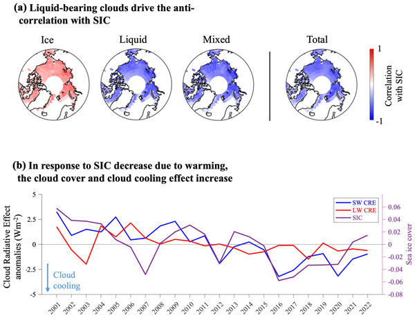
Better characterizing the relationship between sea ice and clouds is key to understanding Arctic climate because clouds and sea ice affect surface radiation and modulate Arctic surface warming. Our results indicate that Arctic liquid clouds robustly increase in response to sea ice decrease. This increase has a cooling effect on the surface because more solar radiation is reflected back to space, and it should contribute to dampening future Arctic surface warming.
McKenna W. Stanford, Ann M. Fridlind, Israel Silber, Andrew S. Ackerman, Greg Cesana, Johannes Mülmenstädt, Alain Protat, Simon Alexander, and Adrian McDonald
Atmos. Chem. Phys., 23, 9037–9069, https://doi.org/10.5194/acp-23-9037-2023, https://doi.org/10.5194/acp-23-9037-2023, 2023
Short summary
Short summary
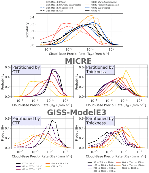
Clouds play an important role in the Earth’s climate system as they modulate the amount of radiation that either reaches the surface or is reflected back to space. This study demonstrates an approach to robustly evaluate surface-based observations against a large-scale model. We find that the large-scale model precipitates too infrequently relative to observations, contrary to literature documentation suggesting otherwise based on satellite measurements.
Frederic Tridon, Israel Silber, Alessandro Battaglia, Stefan Kneifel, Ann Fridlind, Petros Kalogeras, and Ranvir Dhillon
Atmos. Chem. Phys., 22, 12467–12491, https://doi.org/10.5194/acp-22-12467-2022, https://doi.org/10.5194/acp-22-12467-2022, 2022
Short summary
Short summary
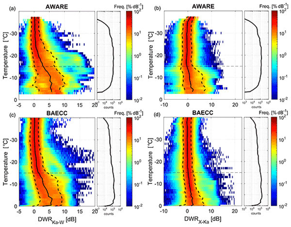
The role of ice precipitation in the Earth water budget is not well known because ice particles are complex, and their formation involves intricate processes. Riming of ice crystals by supercooled water droplets is an efficient process, but little is known about its importance at high latitudes. In this work, by exploiting the deployment of an unprecedented number of remote sensing systems in Antarctica, we find that riming occurs at much lower temperatures compared with the mid-latitudes.

Israel Silber, Robert C. Jackson, Ann M. Fridlind, Andrew S. Ackerman, Scott Collis, Johannes Verlinde, and Jiachen Ding
Geosci. Model Dev., 15, 901–927, https://doi.org/10.5194/gmd-15-901-2022, https://doi.org/10.5194/gmd-15-901-2022, 2022
Short summary
Short summary
The Earth Model Column Collaboratory (EMC2) is an open-source ground-based (and air- or space-borne) lidar and radar simulator and subcolumn generator designed for large-scale models, in particular climate models, applicable also for high-resolution models. EMC2 emulates measurements while remaining faithful to large-scale models' physical assumptions implemented in their cloud or radiation schemes. We demonstrate the use of EMC2 to compare AWARE measurements with the NASA GISS ModelE3 and LES.
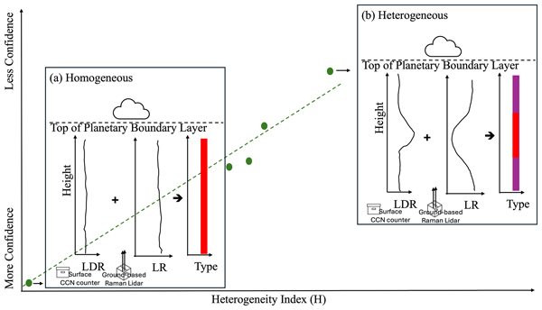
Jingjing Tian, Gourihar Kulkarni, Jennifer M. Comstock, John E. Shilling, Damao Zhang, Peng Wu, and Fan Mei
Atmos. Meas. Tech., 19, 5051–5069, https://doi.org/10.5194/amt-19-5051-2026, https://doi.org/10.5194/amt-19-5051-2026, 2026
Short summary
Short summary
Cloud condensation nuclei are tiny particles that attract water vapor and help form clouds. A ground-based lidar method can estimate their number at different heights, but assumes the aerosol type does not change with height. Comparisons with aircraft data show good agreement of this method when aerosols are well mixed, but larger errors when stacked layers occur. We also developed an index to flag these complex conditions and indicate when this estimation method is more reliable.
Min Deng, Scott Giangrande, Adam K. Theisen, Karen Johnson, Iosif A. Lindenmaier, Timothy G. Wendler, Jennifer Comstock, Marquette Rocque, Zeen Zhu, and Alyssa Matthews
EGUsphere, https://doi.org/10.5194/egusphere-2026-3304, https://doi.org/10.5194/egusphere-2026-3304, 2026
Short summary
Short summary
Cloud radars are used to measure air motion, clouds, and precipitation, but small pointing errors can reduce their accuracy. We developed a method to detect these errors using routine weather balloon observations. Tests with several radar systems in different environments showed that the method can identify small but important pointing biases, helping improve the accuracy and long-term consistency of weather and climate observations.
Fan Mei, Jian Wang, Israel Silber, Nurun Nahar Lata, Gregory W. Vandergrift, Jing Li, Bo Chen, Sarah Brooks, Michael P. Jensen, Min Deng, Damao Zhang, Darielle Dexheimer, Beat Schmid, Zezhen Cheng, and Swarup China
EGUsphere, https://doi.org/10.5194/egusphere-2026-2245, https://doi.org/10.5194/egusphere-2026-2245, 2026
Short summary
Short summary
Tethered balloon measurements from 149 flights during DOE ARM TRACER over Houston characterize vertical aerosol and CCN structure. Back-trajectory clustering identifies three air mass types—marine, mixed, and urban—with distinct profiles shaped by boundary-layer depth and coastal circulations. A case study shows mesoscale advection simultaneously transforms thermodynamic and aerosol conditions, underscoring the need to constrain meteorology before attributing cloud changes to aerosol forcing.
Timothy W. Juliano, Florian Tornow, Ann M. Fridlind, Andrew S. Ackerman, Gregory S. Elsaesser, Bart Geerts, Christian P. Lackner, David Painemal, Israel Silber, Mikhail Ovchinnikov, Gunilla Svensson, Michael Tjernström, Peng Wu, Alejandro Baró Pérez, Peter Bogenschutz, Dmitry Chechin, Kamal Kant Chandrakar, Jan Chylik, Andrey Debolskiy, Rostislav Fadeev, Anu Gupta, Luisa Ickes, Michail Karalis, Martin Köhler, Branko Kosovic, Peter Kuma, Weiwei Li, Evgeny Mortikov, Hugh Morrison, Roel A. J. Neggers, Anna Possner, Tomi Raatikainen, Lea Raillard, Sami Romakkaniemi, Niklas Schnierstein, Shin-ichiro Shima, Nikita Silin, Mikhail Tolstykh, Étienne Vignon, Lulin Xue, Meng Zhang, and Xue Zheng
EGUsphere, https://doi.org/10.5194/egusphere-2026-1237, https://doi.org/10.5194/egusphere-2026-1237, 2026
Short summary
Short summary
Models struggle to capture cloud and precipitation processes and their radiative effects in marine cold-air outbreaks. We use a quasi-Lagrangian framework to compare large-eddy simulation (LES) and single-column model (SCM) output with field and satellite observations. With fixed droplet and ice numbers, LES and SCM agree in liquid-only tests. In mixed-phase conditions, LES plausibly capture cloud thinning and breakup, while SCMs largely remain overcast and thereby miss cloud radiative effects.
Yijia Sun, Ann M. Fridlind, Israel Silber, Nicole Riemer, and Daniel A. Knopf
Geosci. Model Dev., 19, 1581–1617, https://doi.org/10.5194/gmd-19-1581-2026, https://doi.org/10.5194/gmd-19-1581-2026, 2026
Short summary
Short summary
The role of Arctic clouds in the regional climate remains uncertain due to insufficient understanding of the amount of liquid droplets and ice crystals present in these clouds. An aerosol-cloud model is employed to examine the role of different aerosol types and freezing parameterizations on the number of ice crystals. The choice of freezing parameterization significantly changes the number of ice crystals impacting the interpretation of the evolution and warming effect of Arctic clouds.
Israel Silber, Jennifer M. Comstock, Adam K. Theisen, Michael R. Kieburtz, Zeen Zhu, and Jenni Kyrouac
Atmos. Meas. Tech., 19, 485–506, https://doi.org/10.5194/amt-19-485-2026, https://doi.org/10.5194/amt-19-485-2026, 2026
Short summary
Short summary
We present PrecipBE, a multi-instrument precipitation event best-estimate data product developed at the Atmospheric Radiation Measurement (ARM) User Facility, providing time series and tabular statistics of events, which could help advance model evaluation and cloud-process studies. We demonstrate PrecipBE's utilization with a brief 30-year trend analysis of ARM Southern Great Plains (SGP) site data, suggesting shorter, less intense events, but rising annual rainfall, driven by rare extremes.
Timothy W. Juliano, Florian Tornow, Ann M. Fridlind, Andrew S. Ackerman, Gregory S. Elsaesser, Bart Geerts, Christian P. Lackner, David Painemal, Israel Silber, Mikhail Ovchinnikov, Gunilla Svensson, Michael Tjernström, Peng Wu, Alejandro Baró Pérez, Peter Bogenschutz, Dmitry Chechin, Kamal Kant Chandrakar, Jan Chylik, Andrey Debolskiy, Rostislav Fadeev, Anu Gupta, Luisa Ickes, Michail Karalis, Martin Köhler, Branko Kosović, Peter Kuma, Weiwei Li, Evgeny Mortikov, Hugh Morrison, Roel A. J. Neggers, Anna Possner, Tomi Raatikainen, Sami Romakkaniemi, Niklas Schnierstein, Shin-ichiro Shima, Nikita Silin, Mikhail Tolstykh, Lulin Xue, Meng Zhang, and Xue Zheng
EGUsphere, https://doi.org/10.5194/egusphere-2025-6217, https://doi.org/10.5194/egusphere-2025-6217, 2026
Preprint archived
Short summary
Short summary
Models struggle to capture cloud and precipitation processes and their radiative effects in marine cold-air outbreaks. We use a quasi-Lagrangian framework to compare large-eddy simulation (LES) and single-column model (SCM) output with field and satellite observations. With fixed droplet and ice numbers, LES and SCM agree in liquid-only tests. In mixed-phase conditions, LES plausibly capture cloud thinning and breakup, while SCMs largely remain overcast and thereby miss cloud radiative effects.

Damao Zhang, Jennifer Comstock, Chitra Sivaraman, Kefei Mo, Raghavendra Krishnamurthy, Jingjing Tian, Tianning Su, Zhanqing Li, and Natalia Roldán-Henao
Atmos. Meas. Tech., 18, 3453–3475, https://doi.org/10.5194/amt-18-3453-2025, https://doi.org/10.5194/amt-18-3453-2025, 2025
Short summary
Short summary
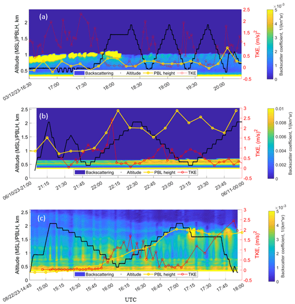
Planetary boundary layer height (PBLHT) is an important parameter in atmospheric process studies and numerical model simulations. We use machine learning methods to produce a best-estimate planetary boundary layer height (PBLHT-BE-ML) by integrating four PBLHT estimates derived from remote sensing measurements. We demonstrated that PBLHT-BE-ML greatly improved the comparisons against sounding-derived PBLHT.
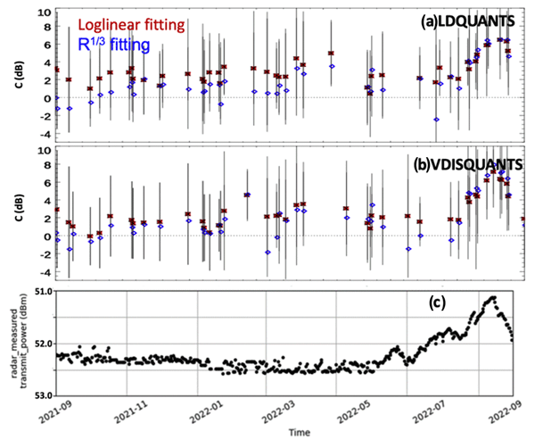
Min Deng, Scott E. Giangrande, Michael P. Jensen, Karen Johnson, Christopher R. Williams, Jennifer M. Comstock, Ya-Chien Feng, Alyssa Matthews, Iosif A. Lindenmaier, Timothy G. Wendler, Marquette Rocque, Aifang Zhou, Zeen Zhu, Edward Luke, and Die Wang
Atmos. Meas. Tech., 18, 1641–1657, https://doi.org/10.5194/amt-18-1641-2025, https://doi.org/10.5194/amt-18-1641-2025, 2025
Short summary
Short summary
A relative calibration technique is developed for the cloud radar by monitoring the intercept of the wet-radome attenuation log-linear behavior as a function of rainfall rates in light and moderate rain conditions. This resulting reflectivity offset during the recent field campaign is compared favorably with the traditional disdrometer comparison near the rain onset, while it also demonstrates similar trends with respect to collocated and independently calibrated reference radars.
Fan Mei, Qi Zhang, Damao Zhang, Jerome D. Fast, Gourihar Kulkarni, Mikhail S. Pekour, Christopher R. Niedek, Susanne Glienke, Israel Silber, Beat Schmid, Jason M. Tomlinson, Hardeep S. Mehta, Xena Mansoura, Zezhen Cheng, Gregory W. Vandergrift, Nurun Nahar Lata, Swarup China, and Zihua Zhu
Atmos. Chem. Phys., 25, 3425–3444, https://doi.org/10.5194/acp-25-3425-2025, https://doi.org/10.5194/acp-25-3425-2025, 2025
Short summary
Short summary
This study highlights the unique capability of the ArcticShark, an uncrewed aerial system, in measuring vertically resolved atmospheric properties. Data from 32 research flights in 2023 reveal seasonal patterns and correlations with conventional measurements. The consistency and complementarity of in situ and remote sensing methods are highlighted. The study demonstrates the ArcticShark’s versatility in bridging data gaps and improving the understanding of vertical atmospheric structures.
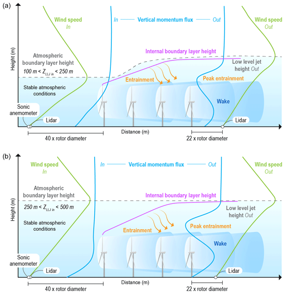
Raghavendra Krishnamurthy, Rob K. Newsom, Colleen M. Kaul, Stefano Letizia, Mikhail Pekour, Nicholas Hamilton, Duli Chand, Donna Flynn, Nicola Bodini, and Patrick Moriarty
Wind Energ. Sci., 10, 361–380, https://doi.org/10.5194/wes-10-361-2025, https://doi.org/10.5194/wes-10-361-2025, 2025
Short summary
Short summary
This study examines how atmospheric phenomena affect the recovery of wind farm wake – the disturbed air behind turbines. In regions like Oklahoma, where wind farms are often clustered, understanding wake recovery is crucial. We found that wind farms can alter phenomena like low-level jets, which are common in Oklahoma, by deflecting them above the wind farm. As a result, the impact of wakes can be observed up to 1–2 km above ground level.
Israel Silber, Jennifer M. Comstock, Michael R. Kieburtz, and Lynn M. Russell
Earth Syst. Sci. Data, 17, 29–42, https://doi.org/10.5194/essd-17-29-2025, https://doi.org/10.5194/essd-17-29-2025, 2025
Short summary
Short summary
We present ARMTRAJ, a set of multipurpose trajectory datasets, which augments cloud, aerosol, and boundary layer studies utilizing the U.S. Department of Energy Atmospheric Radiation Measurement (ARM) user facility data. ARMTRAJ data include ensemble run statistics that enhance consistency and serve as uncertainty metrics for air mass coordinates and state variables. ARMTRAJ will soon become a near real-time product that will accompany past, ongoing, and future ARM deployments.
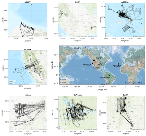
Fan Mei, Jennifer M. Comstock, Mikhail S. Pekour, Jerome D. Fast, Krista L. Gaustad, Beat Schmid, Shuaiqi Tang, Damao Zhang, John E. Shilling, Jason M. Tomlinson, Adam C. Varble, Jian Wang, L. Ruby Leung, Lawrence Kleinman, Scot Martin, Sebastien C. Biraud, Brian D. Ermold, and Kenneth W. Burk
Earth Syst. Sci. Data, 16, 5429–5448, https://doi.org/10.5194/essd-16-5429-2024, https://doi.org/10.5194/essd-16-5429-2024, 2024
Short summary
Short summary
Our study explores a comprehensive dataset from airborne field studies (2013–2018) conducted using the US Department of Energy's Gulfstream 1 (G-1). The 236 flights span diverse regions, including the Arctic, US Southern Great Plains, US West Coast, eastern North Atlantic, Amazon Basin in Brazil, and Sierras de Córdoba range in Argentina. This dataset provides unique insights into atmospheric dynamics, aerosols, and clouds and makes data available in a more accessible format.
Abigail S. Williams, Jeramy L. Dedrick, Lynn M. Russell, Florian Tornow, Israel Silber, Ann M. Fridlind, Benjamin Swanson, Paul J. DeMott, Paul Zieger, and Radovan Krejci
Atmos. Chem. Phys., 24, 11791–11805, https://doi.org/10.5194/acp-24-11791-2024, https://doi.org/10.5194/acp-24-11791-2024, 2024
Short summary
Short summary
The measured aerosol size distribution modes reveal distinct properties characteristic of cold-air outbreaks in the Norwegian Arctic. We find higher sea spray number concentrations, smaller Hoppel minima, lower effective supersaturations, and accumulation-mode particle scavenging during cold-air outbreaks. These results advance our understanding of cold-air outbreak aerosol–cloud interactions in order to improve their accurate representation in models.
Evgueni Kassianov, Connor J. Flynn, James C. Barnard, Brian D. Ermold, and Jennifer M. Comstock
Atmos. Meas. Tech., 17, 4997–5013, https://doi.org/10.5194/amt-17-4997-2024, https://doi.org/10.5194/amt-17-4997-2024, 2024
Short summary
Short summary
Conventional ground-based radiometers commonly measure solar radiation at a few wavelengths within a narrow spectral range. These limitations prevent improved retrievals of aerosol, cloud, and surface characteristics. To address these limitations, an advanced ground-based radiometer with expanded spectral coverage and hyperspectral capability is introduced. Its good performance is demonstrated using reference data collected over three coastal regions with diverse types of aerosols and clouds.
Grégory V. Cesana, Olivia Pierpaoli, Matteo Ottaviani, Linh Vu, Zhonghai Jin, and Israel Silber
Atmos. Chem. Phys., 24, 7899–7909, https://doi.org/10.5194/acp-24-7899-2024, https://doi.org/10.5194/acp-24-7899-2024, 2024
Short summary
Short summary
Better characterizing the relationship between sea ice and clouds is key to understanding Arctic climate because clouds and sea ice affect surface radiation and modulate Arctic surface warming. Our results indicate that Arctic liquid clouds robustly increase in response to sea ice decrease. This increase has a cooling effect on the surface because more solar radiation is reflected back to space, and it should contribute to dampening future Arctic surface warming.
McKenna W. Stanford, Ann M. Fridlind, Israel Silber, Andrew S. Ackerman, Greg Cesana, Johannes Mülmenstädt, Alain Protat, Simon Alexander, and Adrian McDonald
Atmos. Chem. Phys., 23, 9037–9069, https://doi.org/10.5194/acp-23-9037-2023, https://doi.org/10.5194/acp-23-9037-2023, 2023
Short summary
Short summary
Clouds play an important role in the Earth’s climate system as they modulate the amount of radiation that either reaches the surface or is reflected back to space. This study demonstrates an approach to robustly evaluate surface-based observations against a large-scale model. We find that the large-scale model precipitates too infrequently relative to observations, contrary to literature documentation suggesting otherwise based on satellite measurements.
Frederic Tridon, Israel Silber, Alessandro Battaglia, Stefan Kneifel, Ann Fridlind, Petros Kalogeras, and Ranvir Dhillon
Atmos. Chem. Phys., 22, 12467–12491, https://doi.org/10.5194/acp-22-12467-2022, https://doi.org/10.5194/acp-22-12467-2022, 2022
Short summary
Short summary
The role of ice precipitation in the Earth water budget is not well known because ice particles are complex, and their formation involves intricate processes. Riming of ice crystals by supercooled water droplets is an efficient process, but little is known about its importance at high latitudes. In this work, by exploiting the deployment of an unprecedented number of remote sensing systems in Antarctica, we find that riming occurs at much lower temperatures compared with the mid-latitudes.
Damao Zhang, Jennifer Comstock, and Victor Morris
Atmos. Meas. Tech., 15, 4735–4749, https://doi.org/10.5194/amt-15-4735-2022, https://doi.org/10.5194/amt-15-4735-2022, 2022
Short summary
Short summary
The planetary boundary layer is the lowest part of the atmosphere. Its structure and depth (PBLHT) significantly impact air quality, global climate, land–atmosphere interactions, and a wide range of atmospheric processes. To test the robustness of the ceilometer-estimated PBLHT under different atmospheric conditions, we compared ceilometer- and radiosonde-estimated PBLHTs using multiple years of U.S. DOE ARM measurements at various ARM observatories located around the world.

Yun Lin, Jiwen Fan, Pengfei Li, Lai-yung Ruby Leung, Paul J. DeMott, Lexie Goldberger, Jennifer Comstock, Ying Liu, Jong-Hoon Jeong, and Jason Tomlinson
Atmos. Chem. Phys., 22, 6749–6771, https://doi.org/10.5194/acp-22-6749-2022, https://doi.org/10.5194/acp-22-6749-2022, 2022
Short summary
Short summary
How sea spray aerosols may affect cloud and precipitation over the region by acting as ice-nucleating particles (INPs) is unknown. We explored the effects of INPs from marine aerosols on orographic cloud and precipitation for an atmospheric river event observed during the 2015 ACAPEX field campaign. The marine INPs enhance the formation of ice and snow, leading to less shallow warm clouds but more mixed-phase and deep clouds. This work suggests models need to consider the impacts of marine INPs.
Huiying Ren, Erol Cromwell, Ben Kravitz, and Xingyuan Chen
Hydrol. Earth Syst. Sci., 26, 1727–1743, https://doi.org/10.5194/hess-26-1727-2022, https://doi.org/10.5194/hess-26-1727-2022, 2022
Short summary
Short summary
We used a deep learning method called long short-term memory (LSTM) to fill gaps in data collected by hydrologic monitoring networks. LSTM accounted for correlations in space and time and nonlinear trends in data. Compared to a traditional regression-based time-series method, LSTM performed comparably when filling gaps in data with smooth patterns, while it better captured highly dynamic patterns in data. Capturing such dynamics is critical for understanding dynamic complex system behaviors.
Israel Silber, Robert C. Jackson, Ann M. Fridlind, Andrew S. Ackerman, Scott Collis, Johannes Verlinde, and Jiachen Ding
Geosci. Model Dev., 15, 901–927, https://doi.org/10.5194/gmd-15-901-2022, https://doi.org/10.5194/gmd-15-901-2022, 2022
Short summary
Short summary
The Earth Model Column Collaboratory (EMC2) is an open-source ground-based (and air- or space-borne) lidar and radar simulator and subcolumn generator designed for large-scale models, in particular climate models, applicable also for high-resolution models. EMC2 emulates measurements while remaining faithful to large-scale models' physical assumptions implemented in their cloud or radiation schemes. We demonstrate the use of EMC2 to compare AWARE measurements with the NASA GISS ModelE3 and LES.
Cited articles
Ackerman, S. A. and Cox, S. K.: Comparison of Satellite and All-Sky Camera Estimates of Cloud Cover during GATE, J. Appl. Meteorol., 20, 581–587, https://doi.org/10.1175/1520-0450(1981)020<0581:COSAAS>2.0.CO;2, 1981.
Buch Jr., K. A. and Sun, C. H.: Cloud classification using whole-sky imager data, in: Report Number: CONF-9503140, 1995.
Calbó, J. and Sabburg, J.: Feature Extraction from Whole-Sky Ground-Based Images for Cloud-Type Recognition, J. Atmos. Ocean. Tech., 25, 3–14, https://doi.org/10.1175/2007JTECHA959.1, 2008.
Clothiaux, E. E., Miller, M. A., Perez, R. C., Turner, D. D., Moran, K. P., Martner, B. E., Ackerman, T. P., Mace, G. G., Marchand, R. T., Widener, K. B., Rodriguez, D. J., Uttal, T., Mather, J. H., Flynn, C. J., Gaustad, K. L., and Ermold, B.: The ARM millimeter wave cloud radars (MMCRs) and the active remote sensing of clouds (ARSCL) value added product (VAP), DOE Tech. Memo. ARM VAP-002.1, https://doi.org/10.2172/1808567, 2001.
Davis, K., Zaitchik, B., Asa-Awuku, A., Bou-Zeid, E., Baidar, S., Boxe, C., Brewer, W. A., Chiao, S., Damoah, R., DeCarlo, P., Demoz, B., Dickerson, R., Giometto, M., Gonzalez-Cruz, J., Jensen, M., Kuang, C., Lamer, K., Li, X., Lombardo, K., Miles, N., Niyogi, D., Pan, Y., Peters, J., Ramamurthy, P., Peng, W., Richardson, S., Sakai, R., Waugh, D., and Zhang, J.: Coastal-Urban-Rural Atmospheric Gradient Experiment (CoURAGE) Science Plan, USDOE Office of Science (SC), Biological and Environmental Research (BER), United States, https://doi.org/10.2172/2429693, 2024.
Dematties, D., Raut, B. A., Park, S., Jackson, R. C., Shahkarami, S., Kim, Y., Sankaran, R., Beckman, P., Collis, S. M., and Ferrier, N.: Let's Unleash the Network Judgment: A Self-Supervised Approach for Cloud Image Analysis, Artif. Intell. Earth Syst., 1–34, https://doi.org/10.1175/AIES-D-22-0063.1, 2023.
Dev, S., Lee, Y. H., and Winkler, S.: Color-Based Segmentation of Sky/Cloud Images From Ground-Based Cameras, IEEE J. Sel. Top. Appl., 10, 231–242, https://doi.org/10.1109/JSTARS.2016.2558474, 2017.
Dong, X., Minnis, P., and Xi, B.: A Climatology of Midlatitude Continental Clouds from the ARM SGP Central Facility: Part I: Low-Level Cloud Macrophysical, Microphysical, and Radiative Properties, J. Climate, 18, 1391–1410, https://doi.org/10.1175/JCLI3342.1, 2005.
Dong, X., Xi, B., and Minnis, P.: A Climatology of Midlatitude Continental Clouds from the ARM SGP Central Facility. Part II: Cloud Fraction and Surface Radiative Forcing, J. Climate, 19, 1765–1783, https://doi.org/10.1175/JCLI3710.1, 2006.
Esteves, J., Cao, Y., Da Silva, N. P., Pestana, R., and Wang, Z.: Identification of clouds using an all-sky imager, in: 2021 IEEE Madrid PowerTech, 2021 IEEE Madrid PowerTech, 1–5, https://doi.org/10.1109/PowerTech46648.2021.9494868, 2021.
Fa, T., Xie, W., Wang, Y., and Xia, Y.: Development of an all-sky imaging system for cloud cover assessment, Appl. Opt., 58, 5516, https://doi.org/10.1364/AO.58.005516, 2019.
Feng, Y.-C., Lindenmaier, I., Deng, M., Wendler, T., Johnson, K., Matthews, A., Castro, V., and Rocque, M.: kazrmd (a1), Atmospheric Radiat. Meas. ARM User Facil. [data set], https://doi.org/10.5439/1976091, 2011.
Fisher, R. A.: Frequency Distribution of the Values of the Correlation Coefficient in Samples from an Indefinitely Large Population, Biometrika, 10, 507, https://doi.org/10.2307/2331838, 1915.
Flynn, D.: asiskyimage (a1), Atmospheric Radiat. Meas. ARM User Facil. [data set], https://doi.org/10.5439/1890632, 2024.
Flynn, D. and Morris, V.: tsicldmask (a1), Atmospheric Radiat. Meas. ARM User Facil. [data set], https://doi.org/10.5439/1992208, 2000a.
Flynn, D. and Morris, V.: tsiskycover (b1), Atmospheric Radiat. Meas. ARM User Facil. [data set], https://doi.org/10.5439/1992207, 2000b.
Flynn, D. and Morris, V.: tsiskyimage (a1), Atmospheric Radiat. Meas. ARM User Facil. [data set], https://doi.org/10.5439/1992206, 2000c.
Free, M. and Sun, B.: Time-Varying Biases in U.S. Total Cloud Cover Data, J. Atmos. Ocean. Tech., 30, 2838–2849, https://doi.org/10.1175/JTECH-D-13-00026.1, 2013.
Free, M., Sun, B., and Yoo, H. L.: Comparison between Total Cloud Cover in Four Reanalysis Products and Cloud Measured by Visual Observations at U.S. Weather Stations, J. Climate, 29, 2015–2021, https://doi.org/10.1175/JCLI-D-15-0637.1, 2016.
Grosvenor, D. P., Sourdeval, O., Zuidema, P., Ackerman, A., Alexandrov, M. D., Bennartz, R., Boers, R., Cairns, B., Chiu, J. C., Christensen, M., Deneke, H., Diamond, M., Feingold, G., Fridlind, A., Hünerbein, A., Knist, C., Kollias, P., Marshak, A., McCoy, D., Merk, D., Painemal, D., Rausch, J., Rosenfeld, D., Russchenberg, H., Seifert, P., Sinclair, K., Stier, P., van Diedenhoven, B., Wendisch, M., Werner, F., Wood, R., Zhang, Z., and Quaas, J.: Remote Sensing of Droplet Number Concentration in Warm Clouds: A Review of the Current State of Knowledge and Perspectives, Rev. Geophys., 56, 409–453, https://doi.org/10.1029/2017RG000593, 2018.
Kassianov, E., Long, C. N., and Ovtchinnikov, M.: Cloud Sky Cover versus Cloud Fraction: Whole-Sky Simulations and Observations, J. Appl. Meteorol., 44, 86–98, https://doi.org/10.1175/JAM-2184.1, 2005.
Kato, S., Loeb, N. G., Rutan, D. A., Rose, F. G., Sun-Mack, S., Miller, W. F., and Chen, Y.: Uncertainty Estimate of Surface Irradiances Computed with MODIS-, CALIPSO-, and CloudSat-Derived Cloud and Aerosol Properties, Surv. Geophys., 33, 395–412, https://doi.org/10.1007/s10712-012-9179-x, 2012.
Ke, G., Meng, Q., Finley, T., Wang, T., Chen, W., Ma, W., Ye, Q., and Liu, T.-Y.: LightGBM: a highly efficient gradient boosting decision tree, in: Proceedings of the 31st International Conference on Neural Information Processing Systems, 3149–3157, ISBN 9781510860964, 2017.
Koren, I., Remer, L. A., Kaufman, Y. J., Rudich, Y., and Martins, J. V.: On the twilight zone between clouds and aerosols, Geophys. Res. Lett., 34, 2007GL029253, https://doi.org/10.1029/2007GL029253, 2007.
Kuang, C., Giangrande, S., Serbin, S., Elsaesser, G., Gentine, P., Heus, T., Oue, M., Peters, J., Smith, J., Steiner, A., McComiskey, A., Jensen, M., Sedlacek, A., Kollias, P., Vogelmann, A., Morrison, H., Petters, M., and Turner, D.: Science Plan for the Deployment of the Third ARM Mobile Facility to the Southeastern United States at the Bankhead National Forest, Alabama (AMF3 BNF), United States, https://doi.org/10.2172/2280575, 2023.
Li, X., Wang, B., Qiu, B., and Wu, C.: An all-sky camera image classification method using cloud cover features, Atmos. Meas. Tech., 15, 3629–3639, https://doi.org/10.5194/amt-15-3629-2022, 2022.
Loeb, N. G., Yang, P., Rose, F. G., Hong, G., Sun-Mack, S., Minnis, P., Kato, S., Ham, S.-H., Smith, W. L., Hioki, S., and Tang, G.: Impact of Ice Cloud Microphysics on Satellite Cloud Retrievals and Broadband Flux Radiative Transfer Model Calculations, J. Climate, 31, 1851–1864, https://doi.org/10.1175/JCLI-D-17-0426.1, 2018.
Logothetis, S.-A., Salamalikis, V., Wilbert, S., Remund, J., Zarzalejo, L. F., Xie, Y., Nouri, B., Ntavelis, E., Nou, J., Hendrikx, N., Visser, L., Sengupta, M., Pó, M., Chauvin, R., Grieu, S., Blum, N., Van Sark, W., and Kazantzidis, A.: Benchmarking of solar irradiance nowcast performance derived from all-sky imagers, Renew. Energ., 199, 246–261, https://doi.org/10.1016/j.renene.2022.08.127, 2022.
Long, C. N., Sabburg, J. M., Calbó, J., and Pagès, D.: Retrieving Cloud Characteristics from Ground-Based Daytime Color All-Sky Images, J. Atmos. Ocean. Tech., 23, 633–652, https://doi.org/10.1175/JTECH1875.1, 2006.
Maahn, M., Burgard, C., Crewell, S., Gorodetskaya, I. V., Kneifel, S., Lhermitte, S., Tricht, K. V., and van Lipzig, N. P. M.: How does the spaceborne radar blind zone affect derived surface snowfall statistics in polar regions?, J. Geophys. Res.-Atmos., 119, 13604–613620, https://doi.org/10.1002/2014JD022079, 2014.
Mace, G., Marchand, R., Keywood, M., Protat, A., Humphries, R., Fiddes, S., McCluskey, C., Siems, S., Huang, Y., May, P., and Ma, P.-L.: Cloud and Precipitation Experiment at Kennaook (Cape-K) Science Plan, ARM user facility, Pacific Northwest National Laboratory, Richland, WA, United States, https://doi.org/10.2172/1986088, 2023.
Mace, G. G. and Benson, S.: The Vertical Structure of Cloud Occurrence and Radiative Forcing at the SGP ARM Site as Revealed by 8 Years of Continuous Data, J. Climate, 21, 2591–2610, https://doi.org/10.1175/2007JCLI1987.1, 2008.
Manandhar, P., Temimi, M., and Aung, Z.: Short-term solar radiation forecast using total sky imager via transfer learning, Energy Rep., 9, 819–828, https://doi.org/10.1016/j.egyr.2022.11.087, 2023.
Mather, J.: Atmospheric Radiation Measurement (ARM) Management Plan, DOE ARM User Facility, Pacific Northwest National Laboratory, Richland, WA, United States, https://doi.org/10.2172/1253897, 2024.
Minnis, P., Trepte, Q. Z., Sun-Mack, S., Chen, Y., Doelling, D. R., Young, D. F., Spangenberg, D. A., Miller, W. F., Wielicki, B. A., Brown, R. R., Gibson, S. C., and Geier, E. B.: Cloud Detection in Nonpolar Regions for CERES Using TRMM VIRS and Terra and Aqua MODIS Data, IEEE T. Geosci. Remote, 46, 3857–3884, https://doi.org/10.1109/TGRS.2008.2001351, 2008.
Morris, V.: Total Sky Imager (TSI) Handbook, DOE Office of Science, Office of Biological and Environmental Research, https://doi.org/10.2172/1020716, 2005.
Morris, V. R.: Ceilometer Instrument Handbook, DOE/SC-ARM-TR-020, DOE Office of Science, Office of Biological and Environmental Research, https://doi.org/10.2172/1036530, 2016.
Park, S., Kim, Y., Ferrier, N. J., Collis, S. M., Sankaran, R., and Beckman, P. H.: Prediction of Solar Irradiance and Photovoltaic Solar Energy Product Based on Cloud Coverage Estimation Using Machine Learning Methods, Atmosphere, 12, 395, https://doi.org/10.3390/atmos12030395, 2021.
Pedregosa, F., Varoquaux, G., Gramfort, A., Michel, V., Thirion, B., Grisel, O., Blondel, M., Prettenhofer, P., Weiss, R., Dubourg, V., Vanderplas, J., Passos, A., Cournapeau, D., Brucher, M., Perrot, M., and Duchesnay, É.: Scikit-learn: Machine Learning in Python, J. Mach. Learn. Res., 12, 2825–2830, 2011.
Pfister, G., McKenzie, R. L., Liley, J. B., Thomas, A., Forgan, B. W., and Long, C. N.: Cloud Coverage Based on All-Sky Imaging and Its Impact on Surface Solar Irradiance, J. Appl. Meteorol., 42, 1421–1434, https://doi.org/10.1175/1520-0450(2003)042<1421:CCBOAI>2.0.CO;2, 2003.
Raut, B. A., Muradyan, P., Sankaran, R., Jackson, R. C., Park, S., Shahkarami, S. A., Dematties, D., Kim, Y., Swantek, J., Conrad, N., Gerlach, W., Shemyakin, S., Beckman, P., Ferrier, N. J., and Collis, S. M.: Optimizing cloud motion estimation on the edge with phase correlation and optical flow, Atmos. Meas. Tech., 16, 1195–1209, https://doi.org/10.5194/amt-16-1195-2023, 2023.
Riley, E. A., Kleiss, J. M., Riihimaki, L. D., Long, C. N., Berg, L. K., and Kassianov, E.: Shallow cumuli cover and its uncertainties from ground-based lidar–radar data and sky images, Atmos. Meas. Tech., 13, 2099–2117, https://doi.org/10.5194/amt-13-2099-2020, 2020.
Sarangi, S. K., Sarangi, C., Patel, N., Madhavan, B. L., Ningombam, S. S., Ravindra, B., and Ratnam, M. V.: Cloud fraction estimation using random forest classifier on sky images, Atmos. Meas. Tech., 18, 5637–5648, https://doi.org/10.5194/amt-18-5637-2025, 2025.
Savoy, F. M., Dev, S., Lee, Y. H., and Winkler, S.: Geo-referencing and stereo calibration of ground-based Whole Sky Imagers using the sun trajectory, in: 2016 IEEE International Geoscience and Remote Sensing Symposium (IGARSS), IGARSS 2016–2016 IEEE International Geoscience and Remote Sensing Symposium, 7473–7476, https://doi.org/10.1109/IGARSS.2016.7730949, 2016.
Schreder-CMS: New All Sky Imaging Solutions, https://eko-instruments.com/us/wp-content/uploads/sites/15/2024/08/new-asi-16-all-sky-imager.pdf (last access: 21 August 2026), 2017.
Silber, I., Verlinde, J., Eloranta, E. W., and Cadeddu, M.: Antarctic cloud macrophysical, thermodynamic phase, and atmospheric inversion coupling properties at McMurdo Station. Part I: Principal data processing and climatology, J. Geophys. Res.-Atmos., 123, 6099–6121, https://doi.org/10.1029/2018JD028279, 2018.
Silber, I., Flynn, D., Cromwell, E., and Ermold, B.: All-sky imager cloud mask, Atmospheric Radiat. Meas. ARM User Facil. [data set], https://doi.org/10.5439/3005849, 2026a.
Silber, I., Flynn, D., Cromwell, E., and Ermold, B.: asiskycover (b0), Atmospheric Radiat. Meas. ARM User Facil. [data set], https://doi.org/10.5439/3005850, 2026b.
Silber, I., Flynn, D., Cromwell, E., and Ermold, B.: asiskycover (b1), Atmospheric Radiat. Meas. ARM User Facil. [data set], https://doi.org/10.5439/1890629, 2026c.
Sisterson, D. L., Peppler, R. A., Cress, T. S., Lamb, P. J., and Turner, D. D.: The ARM Southern Great Plains (SGP) Site, Meteor. Mon., 57, 6.1–6.14, https://doi.org/10.1175/AMSMONOGRAPHS-D-16-0004.1, 2016.
Song, S., Yang, Z., Goh, H., Huang, Q., and Li, G.: A novel sky image-based solar irradiance nowcasting model with convolutional block attention mechanism, Energy Rep., 8, 125–132, https://doi.org/10.1016/j.egyr.2022.02.166, 2022.
Verlinde, J., Zak, B. D., Shupe, M. D., Ivey, M. D., and Stamnes, K.: The ARM North Slope of Alaska (NSA) Sites, Meteor. Mon., 57, 8.1–8.13, https://doi.org/10.1175/AMSMONOGRAPHS-D-15-0023.1, 2016.
Wagner, T. J. and, Kleiss, J. M.: Error Characteristics of Ceilometer-Based Observations of Cloud Amount, J. Atmos. Oceanic Technol., 33, 1557–1567, https://doi.org/10.1175/JTECH-D-15-0258.1, 2016.
Wang, M., Zhou, S., Yang, Z., and Liu, Z.: CloudA: A Ground-Based Cloud Classification Method with a Convolutional Neural Network, J. Atmos. Ocean. Techn., 37, 1661–1668, https://doi.org/10.1175/JTECH-D-19-0189.1, 2020.
Wang, Y. and Zhao, C.: Can MODIS cloud fraction fully represent the diurnal and seasonal variations at DOE ARM SGP and Manus sites?, J. Geophys. Res.-Atmos., 122, 329–343, https://doi.org/10.1002/2016JD025954, 2017.
Werkmeister, A., Lockhoff, M., Schrempf, M., Tohsing, K., Liley, B., and Seckmeyer, G.: Comparing satellite- to ground-based automated and manual cloud coverage observations – a case study, Atmos. Meas. Tech., 8, 2001–2015, https://doi.org/10.5194/amt-8-2001-2015, 2015.
Widener, K. B., Bharadwaj, N., and Johnson, K.: Ka-Band ARM Zenith Radar (KAZR) Instrument Handbook, ARM-TR-106, DOE Office of Science, Office of Biological and Environmental Research, https://doi.org/10.2172/1035855, 2012.
Wood, R., Wyant, M., Bretherton, C. S., Rémillard, J., Kollias, P., Fletcher, J., Stemmler, J., de Szoeke, S., Yuter, S., Miller, M., Mechem, D., Tselioudis, G., Chiu, J. C., Mann, J. A. L., O'Connor, E. J., Hogan, R. J., Dong, X., Miller, M., Ghate, V., Jefferson, A., Min, Q., Minnis, P., Palikonda, R., Albrecht, B., Luke, E., Hannay, C., and Lin, Y.: Clouds, Aerosols, and Precipitation in the Marine Boundary Layer: An Arm Mobile Facility Deployment, B. Am. Meteorol. Soc., 96, 419–440, https://doi.org/10.1175/BAMS-D-13-00180.1, 2015.
Xie, W., Liu, D., Yang, M., Chen, S., Wang, B., Wang, Z., Xia, Y., Liu, Y., Wang, Y., and Zhang, C.: SegCloud: a novel cloud image segmentation model using a deep convolutional neural network for ground-based all-sky-view camera observation, Atmos. Meas. Tech., 13, 1953–1961, https://doi.org/10.5194/amt-13-1953-2020, 2020.
Zhang, D., Ermold, B., and Morris, V.: ceil, Atmospheric Radiat. Meas. ARM User Facil. [data set], https://doi.org/10.5439/1181954, 1996.
Zhao, W., Marchand, R., and Fu, Q.: The diurnal cycle of clouds and precipitation at the ARM SGP site: Cloud radar observations and simulations from the multiscale modeling framework, J. Geophys. Res.-Atmos., 122, 7519–7536, https://doi.org/10.1002/2016JD026353, 2017.
Short summary
We describe ASISKYCOVER, a new machine learning algorithm for pixel segmentation of all-sky imager (ASI-16) data used by the Atmospheric Radiation Measurement (ARM) User Facility. ASISKYCOVER provides cloud cover and thickness estimates, detects artifacts, and reports uncertainties. Using one year of data from the ARM Southern Great Plains site and comparisons with other ARM datasets, we demonstrate its use and robustness, which will improve cloud cover analyses and data evaluation efforts.
We describe ASISKYCOVER, a new machine learning algorithm for pixel segmentation of all-sky...


