
Articles | Volume 19, issue 17
https://doi.org/10.5194/amt-19-5697-2026
© Author(s) 2026. This work is distributed under
the Creative Commons Attribution 4.0 License.
the Creative Commons Attribution 4.0 License.
https://doi.org/10.5194/amt-19-5697-2026
© Author(s) 2026. This work is distributed under
the Creative Commons Attribution 4.0 License.
the Creative Commons Attribution 4.0 License.
Research article
| 
08 Sep 2026
Research article |
| 08 Sep 2026
| 08 Sep 2026
Modelling monthly Boundary Layer Height maps combining radiosonde, satellite, and reanalysis over Europe
Carina I. Argañaraz
CORRESPONDING AUTHOR

Department of Physical and Chemical Sciences, Università degli Studi dell'Aquila, Via Vetoio, 67100 L'Aquila, Italy
Center of Excellence in Telesensing of Environment and Model Prediction of Severe events (CETEMPS), Università degli Studi dell'Aquila, Via Vetoio, 67100 L'Aquila, Italy
Andreu Salcedo-Bosch
CNR-IMAA, Contrada S. Loja snc, 85050 Tito Scalo (PZ), Italy
Simone Lolli
CNR-IMAA, Contrada S. Loja snc, 85050 Tito Scalo (PZ), Italy
Gabriele Curci
Department of Physical and Chemical Sciences, Università degli Studi dell'Aquila, Via Vetoio, 67100 L'Aquila, Italy
Center of Excellence in Telesensing of Environment and Model Prediction of Severe events (CETEMPS), Università degli Studi dell'Aquila, Via Vetoio, 67100 L'Aquila, Italy
Related authors
No articles found.
Wei Hu, Jason Blake Cohen, Lingxiao Lu, Bo Zheng, Pravash Tiwari, Simone Lolli, Andrea Garzelli, Jun Li, and Kai Qin
EGUsphere, https://doi.org/10.5194/egusphere-2026-4468, https://doi.org/10.5194/egusphere-2026-4468, 2026
This preprint is open for discussion and under review for Atmospheric Chemistry and Physics (ACP).
Short summary
Short summary
This study presents a perturbation experiment to investigate the impact of satellite data uncertainty which are not fully removed using a fast and physically-based divergence operator. The shape of the uncertainty distribution governs error propagation and thus effects the stability of derived fluxes. Coal-based emissions sources are reliably captured. These results provide a practical, uncertainty‑aware filter for satellite‑derived methane emissions.
Antonio Mazza, Benedetto De Rosa, Ilaria Gandolfi, Emilio Lapenna, Simone Lolli, Fabrizio Marra, Lucia Mona, Ermann Ripepi, Marco Rosoldi, Gemine Vivone, and Giuseppe D'Amico
EGUsphere, https://doi.org/10.5194/egusphere-2026-4448, https://doi.org/10.5194/egusphere-2026-4448, 2026
This preprint is open for discussion and under review for Atmospheric Measurement Techniques (AMT).
Short summary
Short summary
We developed and tested a new method to estimate the height of the atmospheric boundary layer, the lowest part of the atmosphere where pollutants and heat are mixed. We applied it to three widely used ceiometers and compared the results with radiosonde observations. The method produced reliable estimates and can be used with existing observation networks, supporting improved monitoring of air quality and atmospheric processes.
Fu Luo, Yuanjian Yang, Ting Sun, Zuofang Zheng, Xueyan Bi, Guoyu Ren, and Simone Lolli
EGUsphere, https://doi.org/10.5194/egusphere-2026-3392, https://doi.org/10.5194/egusphere-2026-3392, 2026
Short summary
Short summary
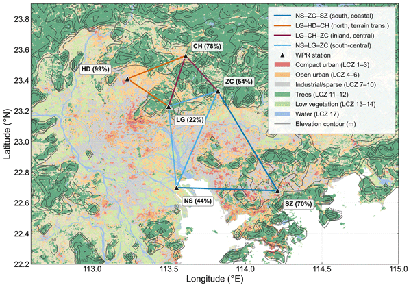
Cities are hotter than surrounding countryside, and heatwaves intensify this contrast. How combined warming reshapes air above different urban areas remains unclear. Using a high-resolution model, we examined two 2020 heatwaves over Guangzhou, China, finding extra warming strongest above densely built neighbourhoods and weakest over open low-rise areas. Dense areas retain heat overnight, adding to next-day warming and showing how urban form shapes extreme heat from surface to lower atmosphere.
Wanju Li, Lifang Sheng, Xueyan Bi, Zehao Huang, Yali Luo, Shiqi Xiao, Chao Liu, Yang Yang, Jiandong Wang, Yuanjian Yang, and Simone Lolli
Atmos. Chem. Phys., 26, 11943–11965, https://doi.org/10.5194/acp-26-11943-2026, https://doi.org/10.5194/acp-26-11943-2026, 2026
Short summary
Short summary
Heavy rain in South China often strikes suddenly far from weather fronts and is hard to forecast. Using five years of radar wind data and rainfall records from Guangdong, we studied 226 events and found warning signs one to four hours before onset that differ by region. In the west, strengthening low-level winds drive the rain; in the Pearl River Delta, friction reshapes the surface wind; in the east, warm surface air stores energy that fuels the storm.
Jiesheng Xue, Yuanjian Yang, Guoyu Ren, and Simone Lolli
Atmos. Chem. Phys., 26, 11543–11560, https://doi.org/10.5194/acp-26-11543-2026, https://doi.org/10.5194/acp-26-11543-2026, 2026
Short summary
Short summary
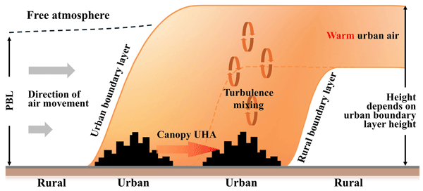
With the reduction in inter-city distances, the wind carries heat downstream to neighboring cities. Focusing on the urban agglomeration area in China, we demonstrate the spatiotemporal variations of this heat transfer process, the moderating influence of meteorological factors, and quantify its effect on the intensity of the urban heat island in downstream cities. The results highlight the necessity of considering inter-city heat interactions in thermal risk management.
Yuanjian Yang, Chenjie Qian, Minxuan Zhang, Chenchao Zhan, Zhenxin Liu, Pak Wai Chan, Xueyan Bi, Meng Gao, and Simone Lolli
Atmos. Meas. Tech., 19, 1345–1363, https://doi.org/10.5194/amt-19-1345-2026, https://doi.org/10.5194/amt-19-1345-2026, 2026
Short summary
Short summary
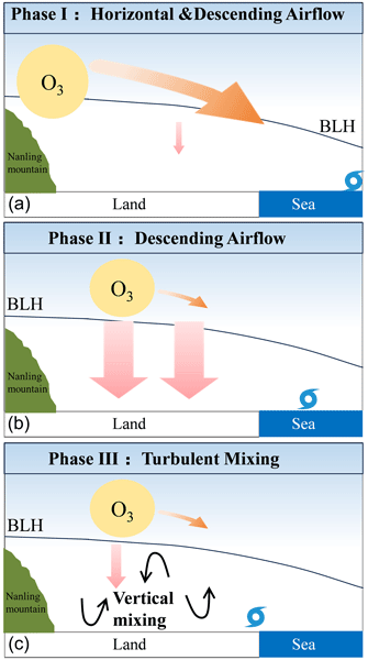
Up to ~ 40 % of ozone pollution in the Greater Bay Area of China is related to tropical cyclones. The O3 pollution was found to be transported from inland areas to coastal areas. The transport process can be roughly divided into three phases: downdraft control, horizontal transport, and vertical mixing.
Bo Zheng, Jason Blake Cohen, Lingxiao Lu, Wei Hu, Pravash Tiwari, Simone Lolli, Andrea Garzelli, Hui Su, and Kai Qin
Atmos. Chem. Phys., 26, 1931–1946, https://doi.org/10.5194/acp-26-1931-2026, https://doi.org/10.5194/acp-26-1931-2026, 2026
Short summary
Short summary
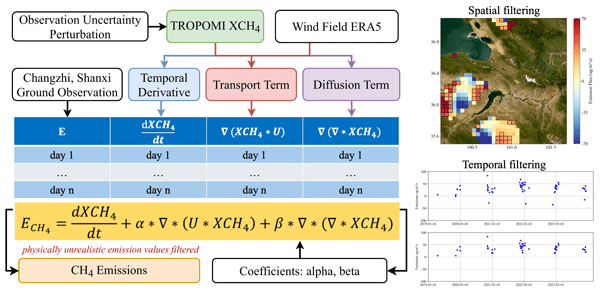
This study provides TROPOMI (TROPOspheric Monitoring Instrument) with a new methane emission estimation method that can accurately identify emission sources. Our results generate non-negative emission datasets using objective selection and filtering methods. The results include lower minimum emission thresholds for all power grids and fewer false positives. The new method provides more robust emission quantification in the face of data uncertainty, going beyond traditional plume identification and background subtraction.
Simone Lolli, Erica K. Dolinar, Jasper R. Lewis, Andreu Salcedo-Bosch, James R. Campbell, and Ellsworth J. Welton
Atmos. Chem. Phys., 26, 411–426, https://doi.org/10.5194/acp-26-411-2026, https://doi.org/10.5194/acp-26-411-2026, 2026
Short summary
Short summary
Over the past twenty years, continuous lidar observations at NASA's Goddard Space Flight Center have assessed the radiative impact of cirrus clouds on the Earth–atmosphere system. Findings show these clouds increasingly trap heat as surface reflectivity drops with less snow and ice, contributing to local warming. Continued cirrus monitoring is crucial to refine climate forecasts and support effective climate action.
Tao Shi, Yuanjian Yang, Gaopeng Lu, Zuofang Zheng, Yucheng Zi, Ye Tian, Lei Liu, and Simone Lolli
Atmos. Chem. Phys., 25, 9219–9234, https://doi.org/10.5194/acp-25-9219-2025, https://doi.org/10.5194/acp-25-9219-2025, 2025
Short summary
Short summary
The city significantly influences thunderstorm and lightning activity, yet the potential mechanisms remain largely unexplored. Our study has revealed that both city size and building density play pivotal roles in modulating thunderstorm and lightning activity. This research not only deepens our understanding of urban meteorology but also lays an important foundation for developing accurate and targeted urban thunderstorm risk prediction models.
Tao Shi, Yuanjian Yang, Lian Zong, Min Guo, Ping Qi, and Simone Lolli
Atmos. Chem. Phys., 25, 4989–5007, https://doi.org/10.5194/acp-25-4989-2025, https://doi.org/10.5194/acp-25-4989-2025, 2025
Short summary
Short summary
Our study explored the daily temperature patterns in urban areas of the Yangtze River Delta, focusing on how weather and human activities impact these patterns. We found that temperatures were higher at night, and weather patterns had a bigger impact during the day, while human activities mattered more at night. This helps us understand and address urban overheating.
Tianwen Wei, Mengya Wang, Kenan Wu, Jinlong Yuan, Haiyun Xia, and Simone Lolli
Atmos. Meas. Tech., 18, 1841–1857, https://doi.org/10.5194/amt-18-1841-2025, https://doi.org/10.5194/amt-18-1841-2025, 2025
Short summary
Short summary
This study analyzes three years of wind lidar measurements to explore the dynamics of the urban planetary boundary layer in Hefei, China. Results reveal that nocturnal low-level jets are most frequent in spring and intensify in summer, significantly enhancing turbulence and shear near the surface, particularly at night. Additionally, cloud cover raises the mixing layer height by approximately 100 m at night due to the greenhouse effect but reduces it by up to 200 m in the afternoon.
Fengjiao Chen, Yuanjian Yang, Lu Yu, Yang Li, Weiguang Liu, Yan Liu, and Simone Lolli
Atmos. Chem. Phys., 25, 1587–1601, https://doi.org/10.5194/acp-25-1587-2025, https://doi.org/10.5194/acp-25-1587-2025, 2025
Short summary
Short summary
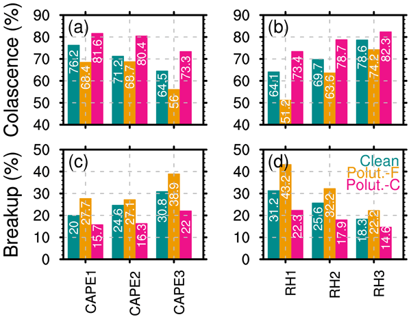
The microphysical mechanisms of precipitation responsible for the varied impacts of aerosol particles on shallow precipitation remain unclear. This study reveals that coarse aerosol particles invigorate shallow rainfall through enhanced coalescence processes, whereas fine aerosol particles suppress shallow rainfall through intensified microphysical breaks. These impacts are independent of thermodynamic environments but are more significant in low-humidity conditions.
Tao Shi, Yuanjian Yang, Ping Qi, and Simone Lolli
Atmos. Chem. Phys., 24, 12807–12822, https://doi.org/10.5194/acp-24-12807-2024, https://doi.org/10.5194/acp-24-12807-2024, 2024
Short summary
Short summary
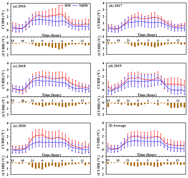
This paper explored the formation mechanisms of the amplified canopy urban heat island intensity (ΔCUHII) during heat wave (HW) periods in the megacity of Beijing from the perspectives of mountain–valley breeze and urban morphology. During the mountain breeze phase, high-rise buildings with lower sky view factors (SVFs) had a pronounced effect on the ΔCUHII. During the valley breeze phase, high-rise buildings exerted a dual influence on the ΔCUHII.
Cristina Gil-Díaz, Michäel Sicard, Adolfo Comerón, Daniel Camilo Fortunato dos Santos Oliveira, Constantino Muñoz-Porcar, Alejandro Rodríguez-Gómez, Jasper R. Lewis, Ellsworth J. Welton, and Simone Lolli
Atmos. Meas. Tech., 17, 1197–1216, https://doi.org/10.5194/amt-17-1197-2024, https://doi.org/10.5194/amt-17-1197-2024, 2024
Short summary
Short summary
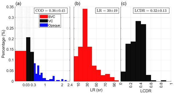
In this paper, a statistical study of cirrus geometrical and optical properties based on 4 years of continuous ground-based lidar measurements with the Barcelona (Spain) Micro Pulse Lidar (MPL) is analysed. The cloud optical depth, effective column lidar ratio and linear cloud depolarisation ratio have been calculated by a new approach to the two-way transmittance method, which is valid for both ground-based and spaceborne lidar systems. Their associated errors are also provided.
Simone Lolli, Michaël Sicard, Francesco Amato, Adolfo Comeron, Cristina Gíl-Diaz, Tony C. Landi, Constantino Munoz-Porcar, Daniel Oliveira, Federico Dios Otin, Francesc Rocadenbosch, Alejandro Rodriguez-Gomez, Andrés Alastuey, Xavier Querol, and Cristina Reche
Atmos. Chem. Phys., 23, 12887–12906, https://doi.org/10.5194/acp-23-12887-2023, https://doi.org/10.5194/acp-23-12887-2023, 2023
Short summary
Short summary
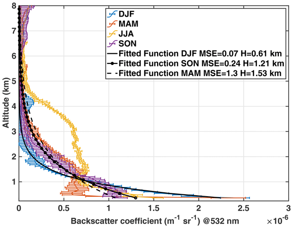
We evaluated the long-term trends and seasonal variability of the vertically resolved aerosol properties over the past 17 years in Barcelona. Results shows that air quality is improved, with a consistent drop in PM concentrations at the surface, as well as the column aerosol optical depth. The results also show that natural dust outbreaks are more likely in summer, with aerosols reaching an altitude of 5 km, while in winter, aerosols decay as an exponential with a scale height of 600 m.
Lian Zong, Yuanjian Yang, Haiyun Xia, Meng Gao, Zhaobin Sun, Zuofang Zheng, Xianxiang Li, Guicai Ning, Yubin Li, and Simone Lolli
Atmos. Chem. Phys., 22, 6523–6538, https://doi.org/10.5194/acp-22-6523-2022, https://doi.org/10.5194/acp-22-6523-2022, 2022
Short summary
Short summary
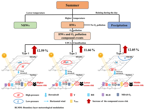
Heatwaves (HWs) paired with higher ozone (O3) concentration at surface level pose a serious threat to human health. Taking Beijing as an example, three unfavorable synoptic weather patterns were identified to dominate the compound HW and O3 pollution events. Under the synergistic stress of HWs and O3 pollution, public mortality risk increased, and synoptic patterns and urbanization enhanced the compound risk of events in Beijing by 33.09 % and 18.95 %, respectively.
Cited articles
Argañaraz, C. I., Salcedo-Bosch, A., Lolli, S., and Curci, G.: Building a high-resolution climate gridded dataset in complex terrain: validating different methods in Abruzzo region in Italy, Int. J. Climatol., 0, e70153, https://doi.org/10.1002/joc.70153, 2025.
Ayazpour, Z., Tao, S., Li, D., Scarino, A. J., Kuehn, R. E., and Sun, K.: Estimates of the spatially complete, observational-data-driven planetary boundary layer height over the contiguous United States, Atmos. Meas. Tech., 16, 563–580, https://doi.org/10.5194/amt-16-563-2023, 2023.
CariArgBio: CariArgBio/Modelling-monthly-Boundary-Layer-Height-maps-combining-different-data-sources: Modelling monthly Boundary Layer Height maps combining different data sources (Version kriging), Zenodo [computer software], https://doi.org/10.5281/zenodo.22232601, 2026.
Cavalleri, F., Viterbo, F., Brunetti, M., Bonanno, R., Manara, V., Lussana, C., Lacavalla, M., and Maugeri, M.: Inter-comparison and validation of high-resolution surface air temperature reanalysis fields over Italy, Int. J. Climatol., 44, 2681–2700, https://doi.org/10.1002/joc.8475, 2024.
Chen, X., Yang, T., Wang, Z., Wang, F., and Wang, H.: An ensemble method for improving the estimation of planetary boundary layer height from radiosonde data, Atmos. Meas. Tech., 16, 4289–4302, https://doi.org/10.5194/amt-16-4289-2023, 2023.
Chicco, D., Warrens, M. J., and Jurman, G.: The coefficient of determination R-squared is more informative than SMAPE, MAE, MAPE, MSE and RMSE in regression analysis evaluation, PeerJ Comput. Sci., 7, e623, https://doi.org/10.7717/peerj-cs.623, 2021.
Cornes, R., van der Schrier, G., van den Besselaar, E. J. M., and Jones, P. D.: An ensemble version of the E-OBS temperature and precipitation datasets, J. Geophys. Res.-Atmos., 123, 9391–9409, https://doi.org/10.1029/2017JD028200, 2018.
Crespi, A., Napoli, A., Galassi, G., Lazzeri, M., Parodi, A., Zardi, D., and Pittore, M.: Leveraging observations and model reanalyses to support regional climate change adaptation activities: an integrated assessment for the Marche Region (Central Italy), Clim. Serv., 36, 100512, https://doi.org/10.1016/j.cliser.2024.100512, 2024.
De Wekker, S. F. J. and Kossmann, M.: Convective boundary layer heights over mountainous terrain – a review of concepts, Front. Earth Sci., 3, 77, https://doi.org/10.3389/feart.2015.00077, 2015.
Dias-Júnior, C. Q., Carneiro, R. G., Fisch, G., D'Oliveira, F. A. F., Sörgel, M., Botía, S., Machado, L. A. T., Wolff, S., Santos, R. M. N. d., and Pöhlker, C.: Intercomparison of planetary boundary layer heights using remote sensing retrievals and ERA5 reanalysis over central Amazonia, Remote Sens., 14, 4561, https://doi.org/10.3390/rs14184561, 2022.
Gu, J., Zhang, Y. H., Yang, N., and Wang, R.: Diurnal variability of the planetary boundary layer height estimated from radiosonde data, Earth Planet. Phys., 4, 479–492, https://doi.org/10.26464/epp2020042, 2020.
Guo, J., Miao, Y., Zhang, Y., Liu, H., Li, Z., Zhang, W., He, J., Lou, M., Yan, Y., Bian, L., and Zhai, P.: The climatology of planetary boundary layer height in China derived from radiosonde and reanalysis data, Atmos. Chem. Phys., 16, 13309–13319, https://doi.org/10.5194/acp-16-13309-2016, 2016.
Guo, J., Li, Y., Cohen, J. B., Li, J., Chen, D., Xu, H., Liu, L., Yin, J., Hu, K., and Zhai, P.: Shift in the temporal trend of boundary layer height in China using long-term (1979–2016) radiosonde data, Geophys. Res. Lett., 46, 6080–6089, https://doi.org/10.1029/2019GL082666, 2019.
Guo, J., Zhang, J., Yang, K., Liao, H., Zhang, S., Huang, K., Lv, Y., Shao, J., Yu, T., Tong, B., Li, J., Su, T., Yim, S. H. L., Stoffelen, A., Zhai, P., and Xu, X.: Investigation of near-global daytime boundary layer height using high-resolution radiosondes: first results and comparison with ERA5, MERRA-2, JRA-55, and NCEP-2 reanalyses, Atmos. Chem. Phys., 21, 17079–17097, https://doi.org/10.5194/acp-21-17079-2021, 2021.
Guo, J., Zhang, J., Shao, J., Chen, T., Bai, K., Sun, Y., Li, N., Wu, J., Li, R., Li, J., Guo, Q., Cohen, J. B., Zhai, P., Xu, X., and Hu, F.: A merged continental planetary boundary layer height dataset based on high-resolution radiosonde measurements, ERA5 reanalysis, and GLDAS, Earth Syst. Sci. Data, 16, 1–14, https://doi.org/10.5194/essd-16-1-2024, 2024.
Hengl, T.: A practical guide to geostatistical mapping, 2nd edn., Office for Official Publications of the European Communities, Luxembourg, https://publications.jrc.ec.europa.eu/repository/handle/JRC38153 (last access: 20 November 2025), 2009.
Hengl, T., Heuvelink, G. B. M., and Rossiter, D. G.: About regression-kriging: from equations to case studies, Comput. Geosci., 33, 1301–1315, https://doi.org/10.1016/j.cageo.2007.05.001, 2007.
Krähenmann, S., Walter, A., Brienen, S., Imbery, F., and Matzarakis, A.: High-resolution grids of hourly meteorological variables for Germany, Theor. Appl. Climatol., 131, 899–926, https://doi.org/10.1007/s00704-016-2003-7, 2018.
Li, X., Dong, Y., Zhang, Y., Shi, Z., and Yao, J.: Climatology of planetary boundary layer height over Jiangsu, China, based on ERA5 reanalysis data, Atmosphere, 14, 1330, https://doi.org/10.3390/atmos14091330, 2023.
Madonna, F., Summa, D., Di Girolamo, P., Marra, F., Wang, Y., and Rosoldi, M.: Assessment of trends and uncertainties in the atmospheric boundary layer height estimated using radiosounding observations over Europe, Atmosphere, 12, 301, https://doi.org/10.3390/atmos12030301, 2021.
Monteith, J. L.: Evaporation and surface temperature, Q. J. R. Meteorol. Soc., 107, 1–27, https://doi.org/10.1002/qj.49710745102, 1981.
Mundu, M. M., Sempewo, J. I., Goparaju, A., and Uti, D. E.: Comparative analysis of model evaluation metrics in energy systems, environmental modeling, and sustainability science, Int. J. Energy Res., 6170467, https://doi.org/10.1155/er/6170467, 2026.
Nelson, K. J., Xie, F., Ao, C. O., and Oyola-Merced, M. I.: Diurnal variation of the planetary boundary layer height observed from GNSS radio occultation and radiosonde soundings over the Southern Great Plains, J. Atmos. Ocean. Technol., 38, 2081–2093, https://doi.org/10.1175/JTECH-D-20-0196.1, 2021.
Pal Arya, S.: Introduction to micrometeorology, Academic Press, San Diego, California, USA, 1988.
Quan, J., Gao, Y., Zhang, Q., Tie, X., Cao, J., Han, S., Meng, J., Chen, P., and Zhao, D.: Evolution of planetary boundary layer under different weather conditions, and its impact on aerosol concentrations, Particuology, 11, 34–40, https://doi.org/10.1016/j.partic.2012.04.005, 2013.
Riley, S. J., De Gloria, S. D., and Elliot, R.: A terrain ruggedness index that quantifies topographic heterogeneity, Intermt. J. Sci., 5, 23–27, 1999.
Roldán-Henao, N., Su, T., and Li, Z.: Refining planetary boundary layer height retrievals from micropulse lidar at multiple ARM sites around the world, J. Geophys. Res.-Atmos., 129, e2023JD040207, https://doi.org/10.1029/2023JD040207, 2024.
Saha, S., Sharma, S., Kumar, K. N., Kumar, P., Lal, S., and Kamat, D.: Investigation of atmospheric boundary layer characteristics using ceilometer lidar, COSMIC GPS RO satellite, radiosonde and ERA-5 reanalysis dataset over the western Indian region, Atmos. Res., 268, 105999, https://doi.org/10.1016/j.atmosres.2021.105999, 2022.
Salcedo-Bosch, A.: Planetary boundary layer height 10-years long (2010–2020) global dataset from radiosonde, Andreu Salcedo-Bosch [data set], https://doi.org/10.5281/zenodo.15639749, 2025.
Salcedo-Bosch, A., Rocadenbosch, F., Argañaraz, C. I., Curci, G., and Lolli, S.: Retrieval of planetary boundary layer height from CALIPSO satellite observations using a machine learning approach, Ecol. Inform., 92, 103431, https://doi.org/10.1016/j.ecoinf.2025.103431, 2025.
Seibert, P., Beyrich, F., Gryning, S.-E., Joffre, S., Rasmussen, A., and Tercier, P.: Review and intercomparison of operational methods for the determination of the mixing height, Atmos. Environ., 34, 1001–1027, https://doi.org/10.1016/S1352-2310(99)00349-0, 2000.
Seidel, D. J., Ao, C. O., and Li, K.: Estimating climatological planetary boundary layer heights from radiosonde observations: comparison of methods and uncertainty analysis, J. Geophys. Res.-Atmos., 115, D16113, https://doi.org/10.1029/2009JD013680, 2010.
Seidel, D. J., Zhang, Y., Beljaars, A., Golaz, J.-C., Jacobson, A. R., and Medeiros, B.: Climatology of the planetary boundary layer over the continental United States and Europe, J. Geophys. Res., 117, D17106, https://doi.org/10.1029/2012JD018143, 2012.
Sinclair, V. A., Ritvanen, J., Urbancic, G., Erner, I., Batrak, Y., Moisseev, D., and Kurppa, M.: Boundary-layer height and surface stability at Hyytiälä, Finland, in ERA5 and observations, Atmos. Meas. Tech., 15, 3075–3103, https://doi.org/10.5194/amt-15-3075-2022, 2022.
Slättberg, N., Lai, H.-W., Chen, X., Ma, Y., and Chen, D.: Spatial and temporal patterns of planetary boundary layer height during 1979–2018 over the Tibetan Plateau using ERA5, Int. J. Climatol., 42, 3360–3377, https://doi.org/10.1002/joc.7420, 2022.
Stapleton, A., Dias-Junior, C. Q., Von Randow, C., Farias D'Oliveira, F. A., Pöhlker, C., de Araújo, A. C., Roantree, M., and Eichelmann, E.: Intercomparison of machine learning models to determine the planetary boundary layer height over Central Amazonia, J. Geophys. Res.-Atmos., 130, e2024JD042488, https://doi.org/10.1029/2024JD042488, 2025.
Stull, R. B.: An introduction to boundary layer meteorology, 1st edn., Kluwer Academic Publishers, Dordrecht, 1988.
Takoutsing, B. and Heuvelink, G. B. M.: Comparing the prediction performance, uncertainty quantification and extrapolation potential of regression kriging and random forest while accounting for soil measurement errors, Geoderma, 428, 116192, https://doi.org/10.1016/j.geoderma.2022.116192, 2022.
Teixeira, J., Piepmeier, J. R., Nehrir, A. R., Ao, C. O., Chen, S. S., Clayson, C. A., Fridlind, A. M., Lebsock, M., McCarty, W., Salmun, H., Santanello, J. A., Turner, D. D., Wang, Z., and Zeng, X.: Toward a global planetary boundary layer observing system: the NASA PBL Incubation Study Team report, NASA PBL Incubation Study Team, Washington, DC, USA, https://science.nasa.gov/wp-content/uploads/2023/05/NASA_PBL_Incubation_Final_Report_2.pdf (last access: 10 September 2025), 2021.
Xu, Z., Chen, H., Guo, J., Zhang, G., Meng, C., Zhang, X., Hu, H., Miao, S., and Zhai, P.: Regionalization of the summertime planetary boundary layer height in comparison with various reanalysis datasets over China, Atmos. Res., 282, 106534, https://doi.org/10.1016/j.atmosres.2022.106534, 2023.
Zhang, D., Comstock, J., Sivaraman, C., Mo, K., Krishnamurthy, R., Tian, J., Su, T., Li, Z., and Roldán-Henao, N.: Best estimate of the planetary boundary layer height from multiple remote sensing measurements, Atmos. Meas. Tech., 18, 3453–3475, https://doi.org/10.5194/amt-18-3453-2025, 2025.
Zhang, H. S., Zhang, X. Y., Li, Q. H., Cai, X. H., Fan, S. J., Song, Y., Hu, F., Che, H., Quan, J., Kang, L., and Zhu, T.: Research progress on estimation of the atmospheric boundary layer height, J. Meteorol. Res., 34, 482–498, https://doi.org/10.1007/s13351-020-9910-3, 2020.
Zhang, P., Bounoua, L., Imhoff, M. L., Wolfe, R. E., and Thome, K.: Comparison of MODIS Land Surface Temperature and Air Temperature over the Continental USA Meteorological Stations, Can. J. Remote Sens., 40, 110–122, https://doi.org/10.1080/07038992.2014.935934, 2014.
Zhang, Y., Seidel, D. J., and Zhang, S.: Trends in planetary boundary layer height over Europe, J. Clim., 26, 10071–10076, https://doi.org/10.1175/JCLI-D-13-00108.1, 2013.
Zhu, C., Wei, Y., Zhu, F., Lu, W., Fang, Z., Li, Z., and Pan, J.: Digital mapping of soil organic carbon based on machine learning and regression kriging, Sensors, 22, 8997, https://doi.org/10.3390/s22228997, 2022.
Short summary
In this study, maps of the planetary boundary layer over Europe were generated by integrating multiple data sources. The results show higher accuracy compared with the widely used ERA5 reanalysis. The proposed regression kriging method performed well in estimating the height of the boundary layer at 12:00 UTC, and to a lesser extent at 00:00 UTC.
In this study, maps of the planetary boundary layer over Europe were generated by integrating...


