
the Creative Commons Attribution 4.0 License.
the Creative Commons Attribution 4.0 License.
 | 27 Oct 2026
A new method for detecting aerosols: combining atmospheric detection LiDAR technology with intelligent driving technology
Xiaomeng Zhu
Duoyang Qiu

Xianyang Li
Zhiqiang Kuang
Zhiyuan Fang
The existing aerosol mobile detection system has problems such as over-reliance on labor power and difficulty in conducting continuous operations in toxic and polluted environments. This paper presents a new method for detecting aerosols. The method combines atmospheric detection LiDAR technology and intelligent driving technology. Through modular design (including control module, aerosol detection module, environment sensing and positioning module, and wire control chassis module), an intelligent cruise detection system for aerosols was built. For path planning, Gaussian pseudo-spectrum method was used. The obstacle avoidance constraints and physical constraints during cruise detection movement was fully considered. Experiments were also conducted for three different application scenarios of continuous vertical detection, scanning detection and unmanned intelligent cruise detection. The experimental results show that the system can effectively and continuously acquire the vertical and spatial distribution of aerosol pollutants. It can achieve three-dimensional scanning and positioning tracking of atmospheric aerosols. The system features unmanned intelligent cruising and detection capabilities, enabling it to provide data on the vertical distribution and dynamic variation of aerosols for regional pollution prevention and control. More detection experiments will be conducted in different environments in the future. We will continue to explore the application of this technology in intelligent cruise control, detection, and pollution prevention, providing new ideas for regional pollution monitoring.
- Article
(7820 KB) - Full-text XML
-
Supplement
(40889 KB) - BibTeX
- EndNote


Aerosols not only affect air quality (Monks et al., 2009), causing reduced visibility and leading to a high incidence of traffic accidents (Gao et al., 2019), but also have an impact on climate (Kok et al., 2023). Some pathogens and viruses can be transmitted via airborne atmospheric aerosols, which may trigger human diseases (Rylander et al., 2020). This poses a serious threat to public health and daily life (Oh et al., 2020; Pope et al., 2002).
Remote sensing techniques are widely applied for atmospheric aerosol monitoring, and can be categorized into two primary types: active remote sensing and passive remote sensing. While ground-based in-situ monitoring features high accuracy, it only yields single-point results and cannot resolve the continuous spatiotemporal distribution of aerosols, particularly their vertical structure (Garrido et al., 2021). As an active remote sensing technique, LiDAR offers inherent advantages over passive detection methods, including ultra-high detection sensitivity, high spatiotemporal resolution, and the capability for three-dimensional target profiling (Eitel et al., 2016). It provides all-weather monitoring of clouds, aerosols, and atmospheric constituents (Cairo et al., 2024), making it widely used for atmospheric environment detection. According to different platforms, it is divided into Space-borne LiDAR, airborne LiDAR and ground-based LiDAR. Large scale and multi latitude atmospheric data can be obtained through space-borne LiDAR, which can provide data for areas that are difficult to observe on the ground (Chen et al., 2023; Sun et al., 2024). Numerous studies have utilized aerosol products derived from spaceborne Light Detection and Ranging (LiDAR) to characterize the surface physicochemical properties and vertical profiles of aerosols, and to investigate their long-range transport processes (Donovan et al., 2024; Sato et al., 2025; Song et al., 2024; Yang et al., 2025). Compared with extensive ground-based LiDAR networks, the number of operational space-borne LiDARs is scarce. Despite continuous performance upgrades of satellite payloads in recent years, the low signal-to-noise ratio caused by orbital overpasses and long slant ranges severely restricts high-frequency, fine-scale continuous monitoring of regional aerosols. Airborne LiDAR is a LiDAR system mounted on aircraft or drones, capable of providing large-area coverage and highly mobile detection scanning. Airborne LiDAR has been widely utilized in atmospheric aerosol research, with applications including investigating the surface properties of desert aerosols, characterizing marine aerosol concentration distributions and the vertical structure of urban pollution (Eckert et al., 2024; Li et al., 2022; Zhou et al., 2022), and measuring the optical properties of atmospheric particulate matter (Girdwood, 2023). Furthermore, multiple studies have leveraged airborne LiDAR-derived aerosol remote sensing products to achieve high-accuracy vertical retrieval of aerosol properties (Burton et al., 2013; Dmitrovic et al., 2024; Müller et al., 2014; Tesche et al., 2009). However, the high cost and airspace limitations have hindered the continued use of airborne LiDAR. Ground-based LiDAR is widely used to detect aerosol pollution (Baars et al., 2026). It can achieve continuous fixed-point detection and effectively monitor the vertical airspace over a specific area (Yang et al., 2024). LiDAR fixed on a building for continuous fixed-point vertical detection (Kuang et al., 2023), it can capture of aerosol transport processes (Yang et al., 2021). Zhang et al. (2024) used a ground-based LiDAR network to analyze a dust aerosol transport over northern China in 21 years. LiDAR paired with a gimbal can carry out scanning detection. Horizontal scanning effectively captures contaminants within the detection distance. It enables pollutants to be effectively tracked and potential sources of contamination to be identified (Kuang et al., 2023). The cone scanning can detect the pollutants in the scanning area by stereoscopic scanning and provide strong data support (Xie et al., 2015). Vertical detection and scanning detection can only achieve fixed-point detection within a specific area, resulting in limited detection coverage. When ground-based LiDAR is mounted on mobile platforms (e.g., vehicle-mounted platforms, shipborne platforms, etc.), navigation-integrated mobile detection can be realized (Sanchez Barrero et al., 2024). This configuration boasts the inherent advantages of long detection range and wide spatial coverage, enabling the implementation of large-scale mobile sounding of atmospheric aerosols (Wang et al., 2024; Zhang et al., 2020). It is even possible to observe the optical characterization of pollutants in a geographic area on a continuously moving basis and to detect sources of pollution (Lv et al., 2017; Wang et al., 2009). Existing studies have established an active-passive synergistic aerosol observation system for marine and terrestrial mobile platform scenarios (Sanchez-Barrero et al., 2026). On one hand, they have utilized aerosol products derived from shipborne LiDAR to reveal the vertical distribution of open-ocean aerosols and the transoceanic transport law of continental aerosols (Duflot et al., 2011; Floutsi et al., 2023; Sanchez-Barrero et al., 2026; Yin et al., 2019). However, shipborne LiDAR is restricted to operation within coastal and open-ocean waters, and is inherently unable to cover key regions for aerosol pollution prevention and control, including inland urban areas, industrial parks, and inland rivers and lakes, nor can it conduct land-based tracking observation of the long-range trans-regional transport of dust aerosols. On the other hand, researchers have developed a vehicle-mounted mobile observation platform equipped with Hyperspectral Resolution LiDAR (HSRL) and passive sensors, achieving high-precision mobile quantitative characterization of the vertical profiles and microphysical properties of clouds and aerosols in the near-surface atmosphere (Chazette and Totems, 2023; Dieudonné et al., 2015; Popovici et al., 2018, 2021; Sanchez Barrero et al., 2024).
However, the need for uninterrupted cruise detection during regional pollution prevention and control actions, can lead to a significant loss of operator energy. This has resulted in a significant increase in labor costs for existing manned cruise detection systems. In addition, being in an environment with high concentrations of toxic pollutant emissions can cause irreversible damage to the bodies of researchers. In order to address the above issues, this paper presents a new method for detecting aerosols. The method combines atmospheric detection LiDAR technology and intelligent driving technology. The system can carry out unmanned cruise detection for long periods of time. Atmospheric LiDAR can be coupled with an autonomous driving platform to enable synergistic mobile observation of atmospheric aerosols. Compared to other platforms, it offers multiple advantages in technical (longer endurance time, simpler system implementation), regulatory (no airspace restrictions), and safety (higher safety) aspects. This work is designed to provide a new approach for regional atmospheric pollutant monitoring. The second part introduces the system and research method. The third part analyzes the results of different experiments. The fourth part is summary and prospect.
2.1 System Principles and Models
Intelligent cruise detection system for aerosols is shown in Fig. 1. The system comprises a control module, an aerosol detection module, an environment sensing and positioning module, and a wire control chassis module, and is integrated into a small electric unmanned vehicle. The control module is composed of industrial controller, computing platform, vehicle controller and gateway. The selected computing platform hosts the Baidu Apollo autonomous driving system. The environment sensing and positioning module includes vehicle LiDAR, binocular camera, and an integrated navigation system (including GPS antenna and inertial navigation). The vehicle LiDAR is a 16-line laser LiDAR, which integrates 16 laser emission channels. It has a maximum detection range exceeding 150 m, a ranging accuracy of ± 2 cm, a point cloud output rate of up to 320 000 points per second, and features a 360° horizontal field of view and a 30° vertical field of view. The binocular camera selected is the “Changjiang-5” binocular stereo camera. In the experimental process of this system, binocular camera serves as an auxiliary sensing method with a relatively low frequency of use and does not act as the primary source of perception information. The wire control chassis module consists of brake module, drive module and steering module.
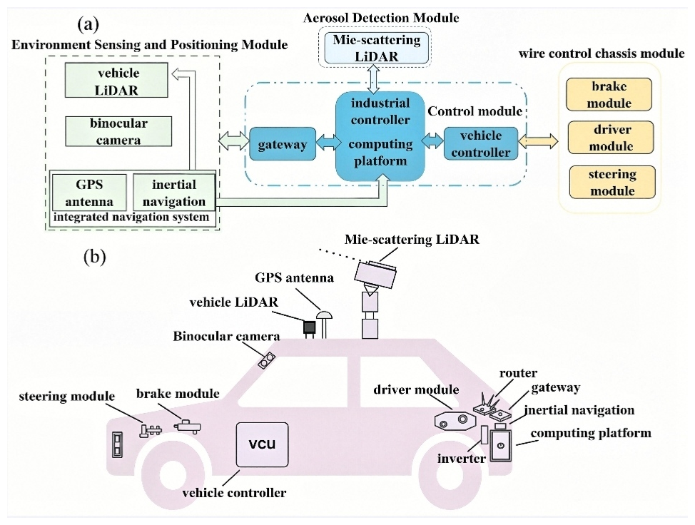
Figure 1Intelligent cruise detection system for aerosols: (a) the system schematic; (b) the module distribution of the detection system (this figure is an original creation by the authors).
The aerosol detection module and the unmanned vehicle system each have their own control units. As the “brain” of the whole system, the control module controls the operation of the whole system. The computing platform receives the localization data and environmental data detected by the environment awareness and localization module through the processing gateway. Based on this input, it's dynamically computing the required gear ratio, velocity parameters, and braking force for the unmanned vehicle and transmits these values via the vehicle controller to the wire control chassis module. The wire control chassis module feeds back the state of the moving vehicle parameters (speed, acceleration, rotational speed and braking, etc.) to the computing platform. The environment sensing and positioning module communicates with the computing platform via the Internet, while the Drive-by-Wire Chassis Module communicates with it via the CAN bus. The aerosol detection module installed on top of the unmanned vehicle employs a compact, portable Mie-scattering LiDAR. The overall dimensions of the Mie-scattering LiDAR are controlled within 200 × 200 × 420 mm, with a total weight of 13.5 kg and a power consumption of less than 100 W (Kuang et al., 2023). The LiDAR system comprises a transmitting optical path, a receiving optical path and a dual-channel detection unit. The 1064 nm laser beam is expanded and emitted into the atmosphere. Backscattered light from aerosols and atmospheric molecules is collected by the receiving telescope, then split into two polarization channels by a polarization prism. The beams are focused onto avalanche photodiodes for photoelectric conversion, followed by multi-pulse integration in the data acquisition card. An embedded control board with dedicated Mie-scattering LiDAR software manages system timing, laser triggering, and data acquisition, storage and transmission.
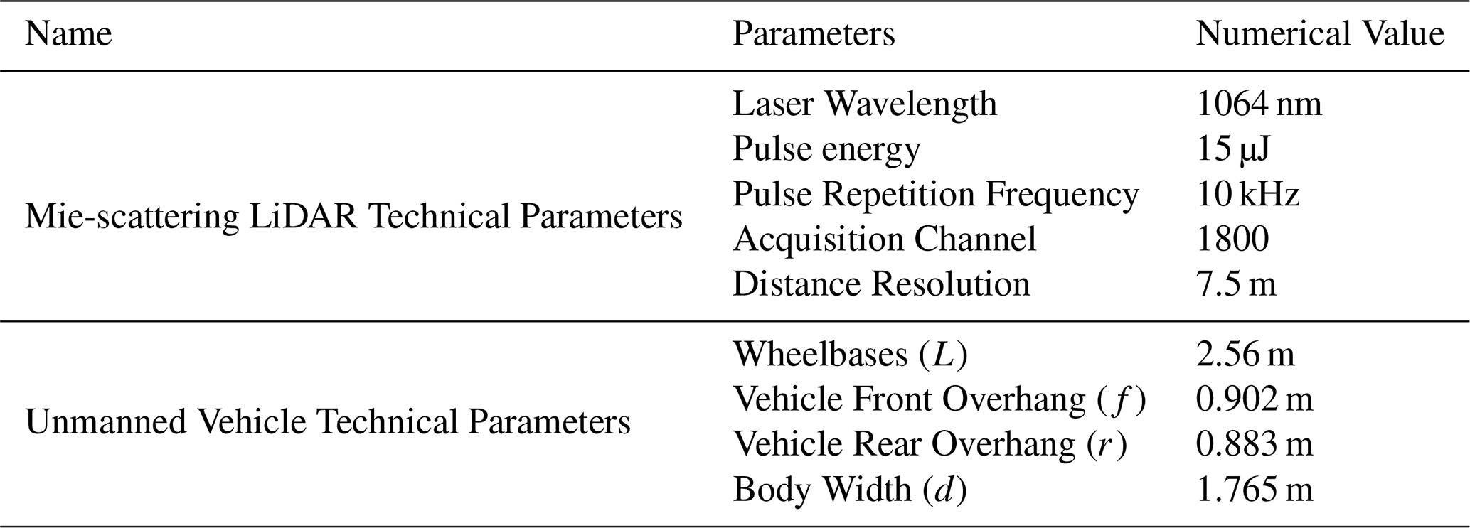
An Nd:YAG solid-state laser emitting 1064 nm eye-safe infrared radiation with a pulse repetition frequency of 10 kHz and a single-pulse energy of 15 µJ is employed in the transmitter. An avalanche photodiode (APD) is used as the photodetector, and a GCC-402053 polarization prism is integrated in the optical path for aerosol depolarization measurement. The LiDAR has a range resolution of 7.5 m and 1800 acquisition channels, with a theoretical maximum detection altitude of 13.5 km. Limited by laser energy attenuation during long-term observation, its practical effective vertical detection altitude stably exceeds 2.5 km, meeting the requirement for vertical pollutant detection in industrial parks.The Mie-scattering LiDAR is equipped with a 1064 nm light source and an APD detector. Developed for aerosol monitoring, it is designed for high-precision detection of the vertical fine structure of aerosols and clouds. Its backscattered LiDAR signals include Mie scattering from aerosol particles and Rayleigh scattering from atmospheric molecules, with Rayleigh scattering generally weaker in the atmospheric boundary layer, where Mie scattering dominates under high aerosol loading (Freudenthaler et al., 2018). The LiDAR system and the industrial controller form an integrated system. All modules within the LiDAR system communicate with the industrial controller via TCP/IP protocols over Ethernet/Wi-Fi networks. The inverter provides a stable 220 V power supply to the LiDAR and computing platform. Figure 1b is the module distribution of the detection system. The relevant technical parameters of the system can be seen in Table 1.
Table 1Relevant technical parameters of intelligent cruise detection system for aerosols.
2.2 Aerosol Detection Methods
Laser pulses are emitted into the atmosphere by the Mie-scattering LiDAR, and energy attenuation of the laser occurs along its propagation path as a result of the atmospheric extinction effect. A portion of these laser pulses are backscattered by aerosol particles and air molecules and returned along the original propagation path, with extinction attenuation undergone once again during the return propagation (Megie, 1985). The telescope of the LiDAR ultimately captures the returning light, and the acquired backscattered LiDAR signals are substituted into the LiDAR equation (Yang et al., 2021):
In Eq. (1), P(z) is the received backscattered LiDAR signals of height z, C is the LiDAR constant. βm and βa are the backscattering coefficients of atmospheric molecules and aerosols respectively. αm and αa are the extinction coefficients of atmospheric molecules and aerosol molecules, respectively. z is the height of aerosol LiDAR detection.
In this study, the original backscattered LiDAR signals are mainly processed by range-squared correction to obtain the Range-Corrected Signal (RCS), which is used to qualitatively reflect the trends in aerosol concentration and vertical distribution characteristics. The equation of Range-corrected signal is:
2.3 Kinematic Model of Unmanned Vehicle and Obstacle Avoidance Constraints
Considering experimental safety, the speed is maintained at a low level, all wheels are in a rolling state, and the influence of lateral force is ignored; vehicle dynamics are ignored, so only the vehicle kinematic model is considered.
In Fig. 2 L, f, r and d are the wheelbase, front overhang, rear overhang and width of the vehicle respectively; point R(x, y) is the center of the rear axle of the vehicle; v is the velocity of point R along the longitudinal axis of the vehicle; O is the instantaneous steering center of the vehicle; φ is the equivalent swing angle of the front wheel; θ is the heading angle of the vehicle; A, B, C and D are the four contour vertices of the vehicle body respectively.
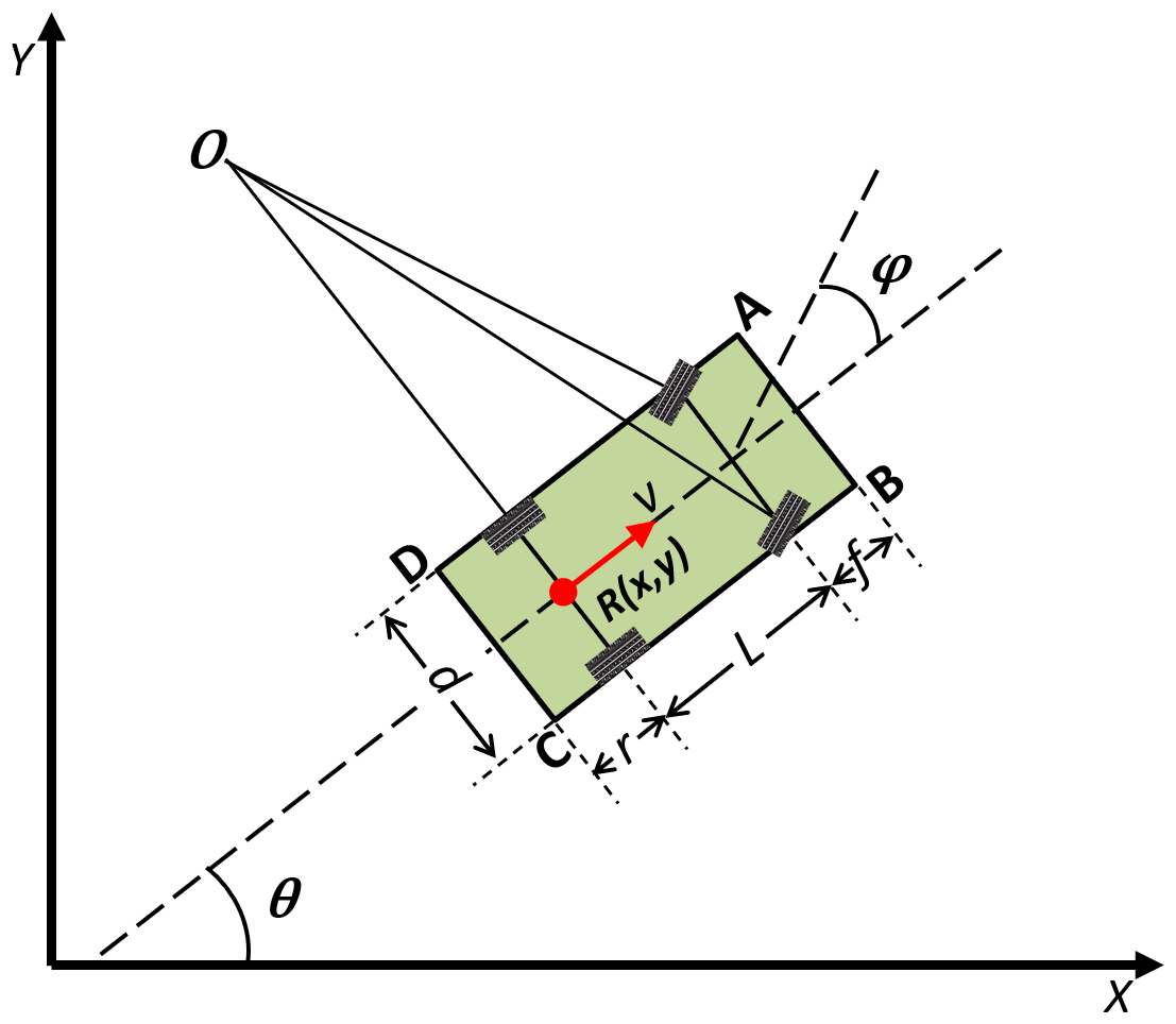
During the vehicle movement process, the state variables of point R(x, y) in the ground coordinate system include: lateral displacement x, longitudinal displacement y, velocity of the rear axle center point v, vehicle acceleration a, vehicle heading angle θ, and equivalent swing angle of the front wheel φ; The control variables include the vehicle acceleration rate j and the angular velocity of the front wheel's equivalent swing angle ω. Thus, the kinematic differential equations of the vehicle can be obtained as follows:
In Eq. (3): t0 and tf are the initial and termination moments respectively of the unmanned vehicle respectively.
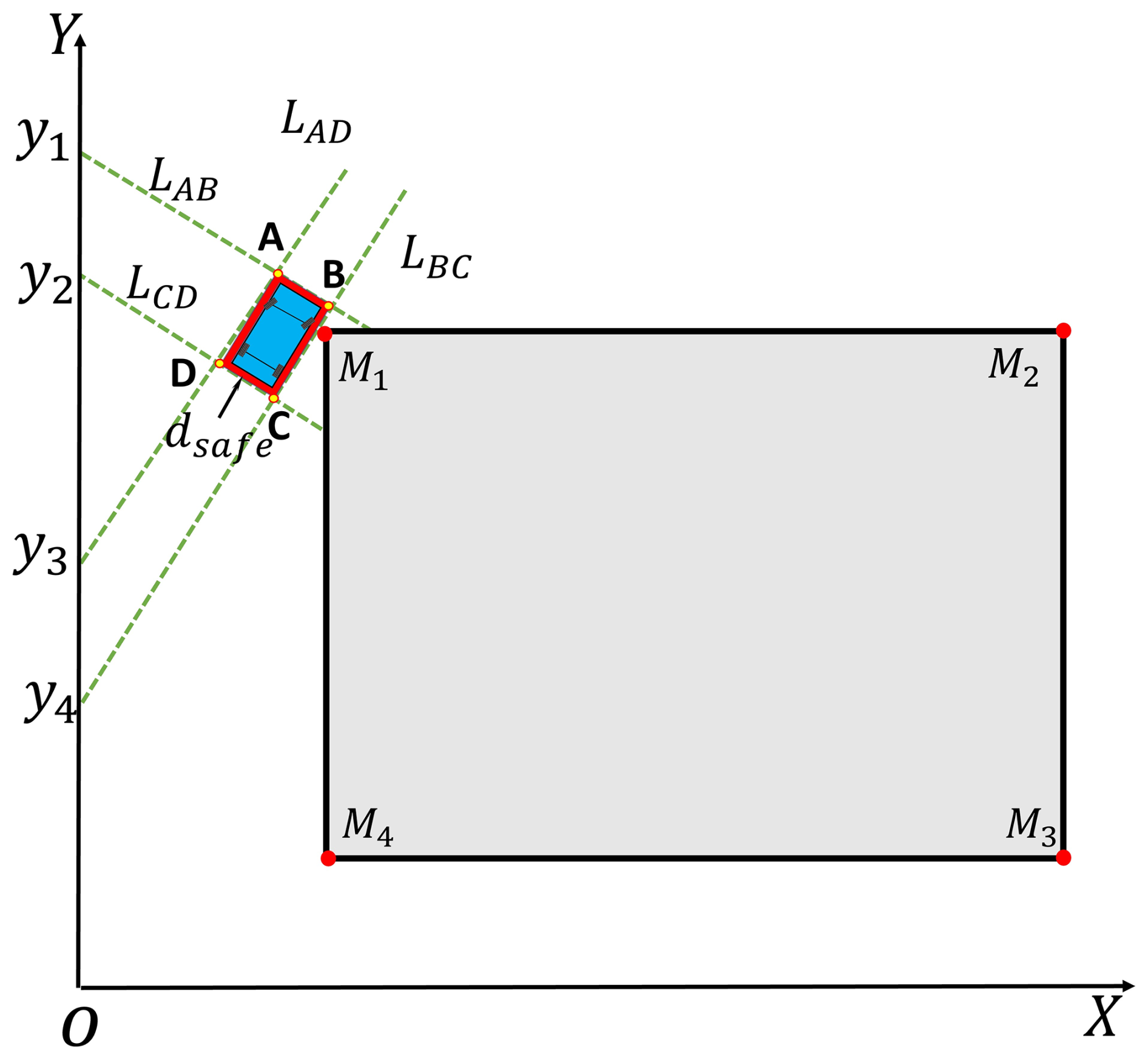
Vehicle collision avoidance constraints are important when solving trajectory planning problems. The actual top-view projection shape of the vehicle is close to a rectangle. Here the vehicle contour is depicted with an enlarged rectangle. dsafe is the safety threshold to ensure that the vehicle is collision free.
As shown in Fig. 3 the red area around the vehicle is the safety threshold to ensure a collision-free vehicle. If the vehicle does not collide with point M while traveling, the point M coordinates are always outside the rectangular ABCD region. Remember that the four sides of the rectangle are the lines LAB, LBC, LCD, and LAD, and their linear equations are as follows:
k1 is the slope of the lines LAB, and LCD, k2 is the slope of the lines LAD, and LBC. If the line LAB is parallel or perpendicular to the X-axis so that the point M is outside the rectangle ABCD, then the coordinates of the point M must satisfy the following conditions:
In Eq. (5), i= 1, 2, 3, 4 represent the four vertices of the rectangle. For a line LAB that is neither parallel nor perpendicular to the X-axis, if point M lies outside the quadrilateral ABCD, the following conditions must hold:
2.4 Unmanned Mobile Detection Path Planning Algorithm
The motion of a vehicle is fundamentally a problem of solving a dynamic system. Incorporating constraints and an objective function then forms an optimal control problem. This paper employs the segmented Gaussian pseudo-spectral method to solve the optimal control problem. The method constructs Lagrange interpolation polynomials to approximate the state and control variables after discretizing the continuous optimization problem at the Legendre-Gauss (LG) collocation point. And replace the differential equation constraints with algebraic constraints, thus transforming the optimal control problem into a Nonlinear Programming (NLP) problem to be solved. Qiu et al. (2021) proposed a hierarchical trajectory planning and tracking control algorithm for unmanned vehicles combining Model Predictive Control (MPC) and Gaussian Pseudo-spectral Method (GPM).
An optimal control problem typically comprises: the system dynamics differential equations, physical constraints, obstacle avoidance constraints, boundary constraints, and a performance index function. The optimal control parameters are obtained by minimizing the performance index function while satisfying all constraints. The Bolza problem in nonlinear optimization is one of the main problems in classical calculus of variations that deals with the conditions for extreme points under certain constraints (Wang et al., 2021). This problem has a special feature of the mixed nature of the functional represented as the sum of an integral functional and a function on the boundary. It not only emphasizes the system state at the terminal moment, but also stresses the requirements for the control system process. Without loss of generality, the Bolza problem for nonlinear optimal control can be described as:
In Eq. (7): ξ(t) and μ(t) are the state and control variables of the system, respectively. The state variables ξ(t) encompass the vehicle's longitudinal displacement x, lateral displacement y, velocity v, acceleration a, heading angle θ, and wheel steering angle φ. The control variables include the wheel angular velocity ω and jerk ξ(t)∈Rn and μ(t)∈Rm satisfy.
In Eq. (8): In the first line, describes the differential equation of state of the system. In the second line, M( represents the inequality constraints in the vehicle's path planning, including collision avoidance constraints and the physical limitations of the vehicle system (such as maximum speed, maximum steering angle, acceleration limits, etc.).In the third line, represents the equality constraints in the vehicle's path planning, including the condition that the vehicle is stationary at both the initial and final times, as well as the continuity constraints in multi-stage planning (i.e., the terminal state of the previous stage must equal the initial state of the subsequent stage).
Based on the above context, the nonlinear optimal control problem for vehicle trajectory planning can be described as follows: the objective is to minimize tf, that is min tf. Meanwhile, within the time interval t∈ [t0, tf], the vehicle system must satisfy the state differential equations, physical system constraints, obstacle avoidance constraints, and boundary condition constraints. The detailed solution procedure of the optimal control problem via the Gaussian pseudospectral method can be found in the Appendix.
Kinematic Eq. (3) defines the feasible motion capability of the vehicle. This equation characterizes the relationship between control inputs (jerk and front-wheel angular velocity) and the evolution of the vehicle states. The obstacle locations provided by the perception module are incorporated as path constraints in the trajectory planning problem, such that all obstacles must remain outside the vehicle's safety envelope throughout the planned path, thereby restricting the feasible state space. The optimal control algorithm searches within this constrained space to solve for the optimal control inputs, ensuring that the generated trajectory avoids obstacles while also adhering to the vehicle's kinematic constraints.
3.1 Vertical Detection
We conducted continuous fixed-point outdoor detection in Hefei (31.8593° N, 117.2160° E) on 24 February 2025. Figure 4a shows the Range-corrected signal data of that day. In Fig. 4a, the temporal evolution of the vertical distribution of the near-surface aerosol layer is illustrated. The height of the aerosol layer was maintained at about 1.5 km for a long period of time. The Range-corrected signal intensity of aerosol exhibits relatively high values below 1 km. The signal intensity shows pronounced temporal variability, gradually decreasing from 1 to 0.2 ∼ 0.3 W × km2 between 06:00 and 17:00 UTC. After 17:00 UTC, the signal intensity recovers and stabilizes at approximately 0.5 W × km2. Clouds were also detected at 2 to 2.5 km.
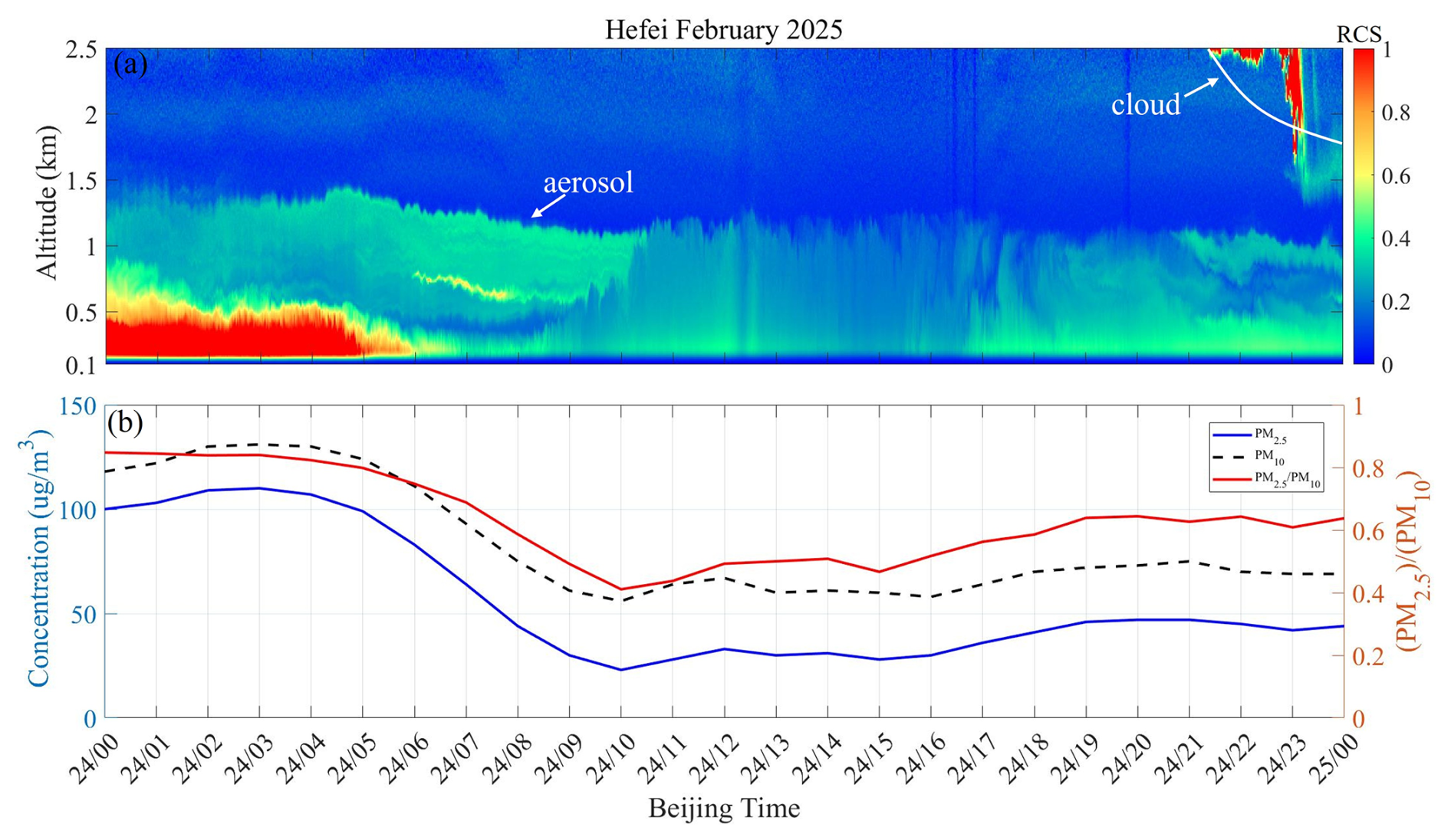
Figure 4Temporal variations in pollutant on 24 February: (a) The Range-corrected signal (W × km2) from Mie-scattering LiDAR;(b) the concentration of particulate matter at the ground station (the blue line indicates PM2.5, the black line segment indicates PM10, and the red line indicates PM2.5 PM10).
Many previous studies have correlated multi-source data with LiDAR data to investigate variations in aerosol concentration (Tu et al., 2022; Xiao et al., 2023). In order to verify the accuracy of the system's detection, we also selected the hourly particulate matter concentration observed at the ground station in Hefei City on 24 February. Figure 4b shows the variation curve of particulate matter concentration on the 24th (daily average concentration thresholds of 150 and 75 µg m−3 for PM10 and PM2.5, respectively). When the PM2.5 PM10 ratio is below 0.5, it means large particle pollutants account for the main part of the air. When the ratio is 0.5 or above, it indicates that air pollution is dominated by fine particle pollutants. PM2.5 and PM10 concentrations were higher than 100 µg m−3 from 00:00 to 05:00 UTC. PM2.5 PM10 values were around 0.8, indicating that the pollution in this phase is local fine particulate matter. Then, the three curves dropped rapidly reaching a minimum at 10:00 UTC (56 µg m−3 for PM10; 23 µg m−3 for PM2.5 and 0.41 for PM2.5 PM10). At 16:00 UTC, the subsequent concentrations all rebounded, and the PM2.5 PM10 value stabilized between 0.5 and 0.6. The variation trend of the particulate matter concentration data is consistent with the detection results of the LiDAR.
To verify the physical rationality of the observation results, the vertical aerosol distribution from this cruise detection is compared with contemporaneous MERRA-2 reanalysis data. As a large-scale product, MERRA-2 reflects the regional aerosol spatiotemporal variation and transport background, while the LiDAR captures fine local vertical structures, showing complementary spatial scales. Given the limited single-day samples and result contingency, MERRA-2 serves only as a large-scale atmospheric reference to confirm the consistency of LiDAR results with regional background characteristics and exclude instrument anomalies and inversion deviations. By retrieving the MERRA-2 reanalysis data (Figs. 5 and 6). Figure 5 shows that Hefei experienced a distinct aerosol pollution episode from the 22nd to the 24th. Figure 6 shows the hourly averaged data on the 23rd. Figure 6a–c illustrate the northwest-to-southeast transport of the pollution plume from 11:30 to 14:30 UTC, with the Hefei area impacted by the pollution process. However, constrained by its relatively coarse spatial resolution, MERRA-2 struggles to capture the details of local, short-term, and vertical variations in aerosols. Through vertical detections and comparative analysis, we can obtain a more refined vertical distribution of aerosols from the LiDAR results. The comparison shows consistency in the main aerosol layer height and signal intensity variation trend, preliminarily verifying the physical rationality of the system observations. Restricted by the test period and site constraints, this study concentrates on the system integration and detection feasibility verification of the unmanned vehicle-borne aerosol LiDAR, and continuous observations under diverse conditions and over multiple periods are not performed in the current work. Future work will expand samples covering different pollution levels and meteorological conditions, and conduct systematic cross-validation and quantitative accuracy evaluation combining MERRA-2 data, ground monitoring data and synchronous fixed-point LiDAR observations.
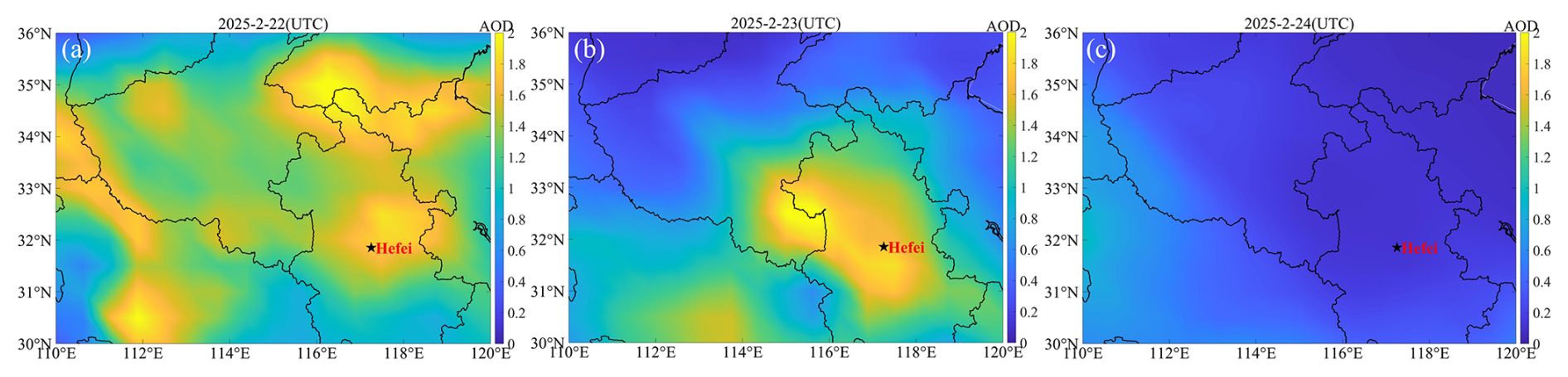
Figure 5MERRA-2 Aerosol Optical Depth Analysis: (a) The results of 22 February 2025; (b) The results of 23 February 2025; and (c) The results of 24 February 2025.
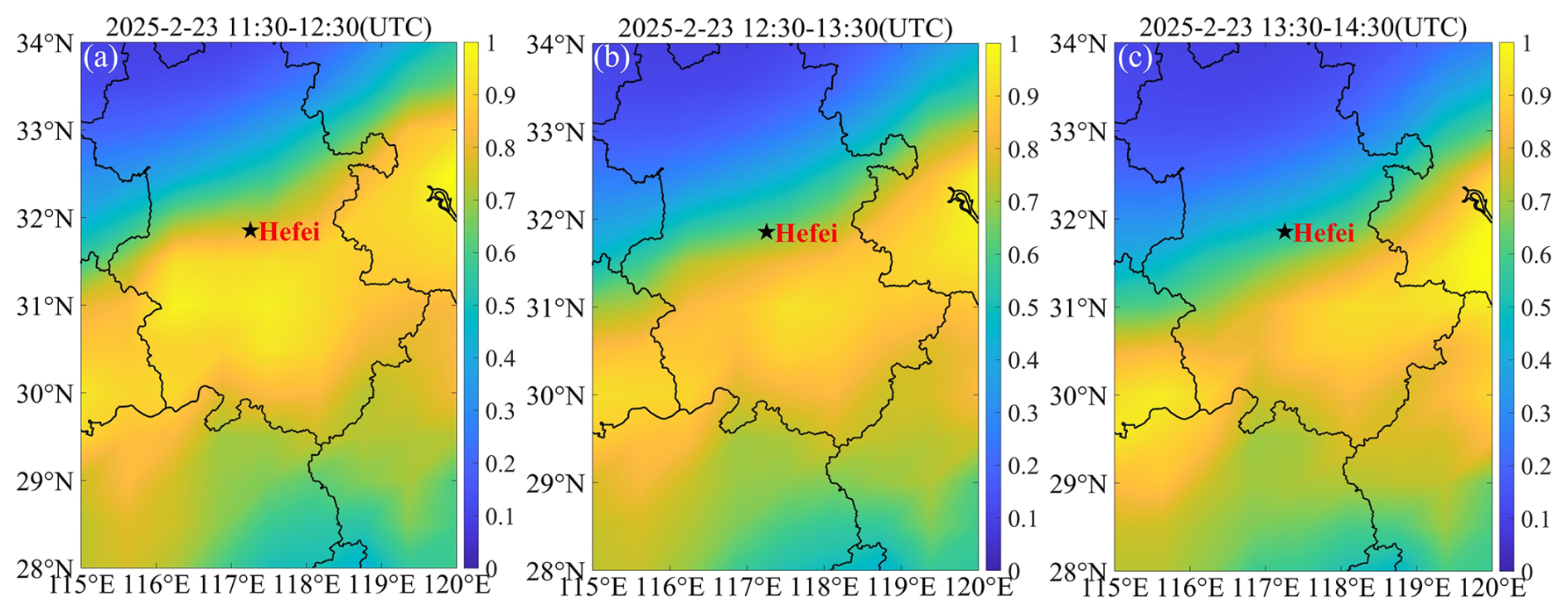
Figure 6MERRA-2 Total Aerosol Extinction AOT: (a) 23 February 2025 11:30–12:30 UTC; (b) 23 February 2025 12:30–14:30 UTC and (c) 23 February 2025 13:30–14:30 UTC; UTC = CST−8 h.
3.2 Cone-Scanning Detection
Cone-scanning detection relies on the synchronous rotation of the LiDAR gimbal in both elevation and azimuth to realize three-dimensional spatial sampling. With a fixed elevation angle, the LiDAR rotates uniformly over the full 0–360° azimuth range to conduct stereoscopic tomographic sampling of the atmosphere within a 2.5 km detection radius. This mode can simultaneously capture the spatial distribution of aerosol and cloud masses at different azimuths and altitudes, compensating for the limitation of fixed-point vertical detection, which only provides single vertical profiles and lacks horizontal spatial coverage.
Owing to constraints imposed by the experimental environment, horizontal scanning is not feasible. We conducted cone-scanning detection experiments in Hefei (31.8593° N, 117.2160° E) on 28 February, 5 and 6 March 2025, respectively. To ensure reliable retrieval results, backscattering LiDAR signals from a sufficient number of independent laser pulses are accumulated at each azimuth angle. The parameters are set as follows: the 0° direction corresponds to due west, the elevation angle is 75°, the step angle is 1°, and the full scan takes approximately 1 h. The Range-corrected data were optioned for a range of 2.5 km. Figure 7 shows the Range-corrected signal of cloudy days (28 February), polluted days (5 March) and clean days (6 March). Cloudy condition on 28 February (Fig. 7a): Continuous cloud echoes are observed at 2 km altitude in the 0–100° southeast azimuth, with only sparse aerosol plumes at 2.1–2.3 km, indicating low overall aerosol loading; Polluted condition on 5 March (Fig. 7b): Thin clouds are widely distributed at 0.85–1.5 km near the ground. Aerosol plumes spread along the scanning circumference with a much larger coverage, and high near-ground backscattered LiDAR signals reflect elevated regional aerosol concentrations; Clean condition on 6 March (Fig. 7c): No concentrated cloud or aerosol signals are observed across the entire detection radius. The values of range-corrected signals stay at extremely low levels throughout the field of view, demonstrating clean atmospheric conditions. The system can achieve three-dimensional scanning and positioning tracking of atmospheric aerosols.
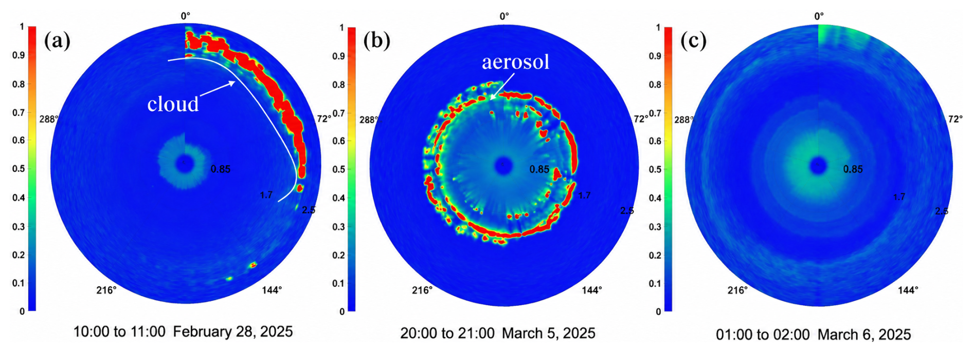
Figure 7Range-corrected signal (W × km2) from cone-scanning detection:(a) The results of 28 February 2025; (b) The results of 5 March 2025; and (c) The results of 6 March 2025.
3.3 Unmanned Intelligent Cruise Detection
We did an unmanned intelligent cruise detection experiment in Hefei (31.8593° N, 117.2160° E) on 26 February. The location of the experiment was chosen near a laboratory building within the school. See Table 1 for unmanned vehicle parameters. The physical constraints are shown in Table 2. Figure 8 shows the validation and simulation analysis of the trajectory planning algorithm based on the Gaussian pseudo-spectral method. Through simulation and emulation, we can achieve obstacle avoidance during the cruising detection process, and ensure safe and normal cruising according to the planned path.

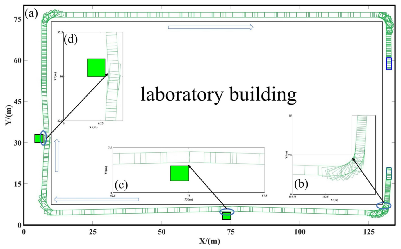
Figure 8Simulation of Cruise Detection Path Planning:(a) Navigation mobile route map; (b), (c) and (d) the simulation of obstacle avoidance for cornering, obstacle 1 and obstacle 2, respectively.
Before the experiment, enter the Mie-scattering LiDAR system to configure the relevant detection parameters. This is followed by turning on the wire control chassis module of the unmanned vehicle and the modules related to the environment sensing and positioning module. Finally, the planned path is selected and the vehicle switches to autopilot.
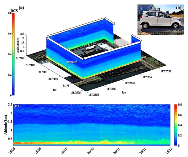
Figure 9 shows a plot of the Range-corrected signal from one unmanned cruise detection. We first clarify the background air pollution conditions on the test day: the air quality index (AQI) of Hefei reached 115,with synchronous ground monitoring values of PM2.5 was 80 µg m−3, and PM10 was 100 µg m−3 (Data from China Environmental Monitoring Station; https://air.cnemc.cn:18007/, last access: 18 October 2026). It can be seen from Fig. 9a that the near-surface pollution layer was confined within the altitude range of 0–0.3 km throughout the observation period. The range-corrected signal gradually decreased from 0.8 to 0.2 W × km2 as the vehicle cruised forward, indicating a continuous reduction of aerosol concentration along the traveling path. In the later stage of the experiment, the aerosol layer rose to 0.5 km, which corresponds to the gradual uplifting of the local atmospheric boundary layer and the increased vertical diffusion height of aerosols over time.
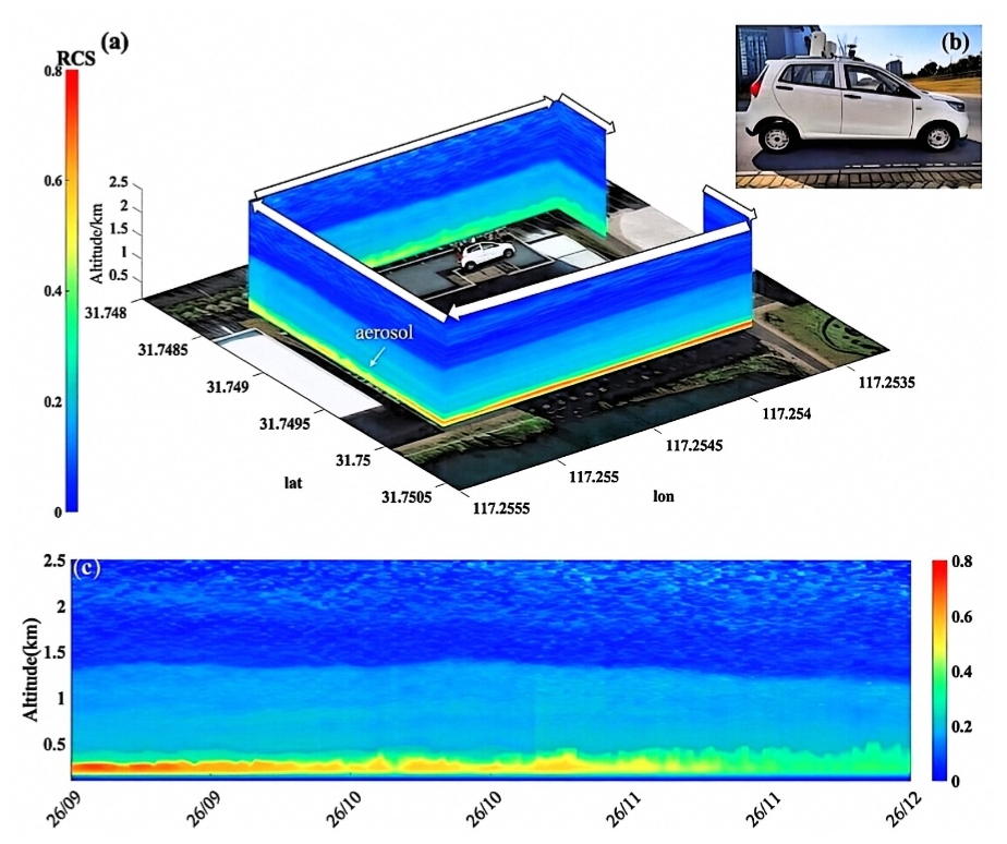
Figure 9Range-corrected signal (W × km2) superimposed on the map:(a) A map of Range-corrected signal for unmanned move detection (arrows are in the direction of vehicle travel); (b) An unmanned vehicle undergoing an unmanned walking experiment;(c) An unmanned Intelligent Cruise Detection: the temporal variation of Range-corrected signal (W × km2). (The map is a simple block map, © 2025Baidu-GS (2023)3206.)
This cruise measurement demonstrates the unique advantages of the vehicle-borne detection system over fixed-point LiDAR. Conventional fixed-site LiDAR can only acquire time-resolved vertical aerosol profiles at a single location. In contrast, this unmanned cruising observation system enables the acquisition of three-dimensional spatial aerosol distributions with geolocation and altitude information.
We have developed an aerosol detection system based on an unmanned driving platform and conducted initial tests. In the future, we will expand the detection scenarios and duration, and conduct diverse detection experiments for various pollution scenarios. In subsequent long-term experiments, the intelligent cruising detection system for complex scenarios will be further optimized. Currently, based on our summarized experience from earlier stages, the following scenarios may arise where our method could fail or degrade in performance. Firstly, when hardware such as LiDAR ages – for instance, laser energy attenuation leads to a decline in detection accuracy. Secondly, the existing path planning algorithm fails to adapt to complex traffic conditions. Since we have not conducted extensive road testing, further research on dynamic obstacle avoidance will be pursued in subsequent work.
Additionally, we are capable of detecting haze and other polluted weather conditions. As shown in Fig. 8, our long-term continuous observations of polluted weather clearly reveal the detailed vertical structure of aerosols. However, our method will also fail when encountering harsh weather conditions such as rain and snow. Raindrops and snowflakes cause intense Mie scattering and absorption of the laser pulses, leading to severe attenuation of the effective backscattered signal and introducing significant background noise. This results in a reduction of the raw signal-to-noise ratio (SNR), thereby affecting the accuracy of aerosol optical parameter retrieval and shortening the effective detection range.
In the initial design phase of the system, we prioritized the implementation of the system's core functionalities, high level of system integration, and overall platform mobility. Therefore, the entire system has indeed not yet undergone rigorous water and dust resistance rating certification tests. Operation under continuous precipitation conditions entails certain operational risks. Vibrations occurring during unmanned intelligent cruise experiments may affect the stability of the LiDAR system. Such vibrations can cause slight misalignment between the transmitting and receiving optical paths, thereby inducing non-aerosol fluctuations in the Range-Corrected Signal (RCS), and may even lead to detection blind zones or a sharp drop in the signal-to-noise ratio. Therefore, to eliminate the influence of vibration, the moving speed was controlled within 1.0 m s−1 in the experiments of this study. In future work, an active vibration damping platform will be installed to improve the data reliability of mobile measurements.
We propose a new approach to aerosol detection that combines atmospheric detection LiDAR technology and smart driving technology. The intelligent cruise detection system for aerosols was built through a modularized design. The system includes: a control module, an aerosol detection module, an environment sensing and positioning module, and a wire control chassis module. Firstly, continuous vertical detection experiments show that the system can continuously observe the vertical distribution of aerosols for a long time (24 h). And it can provide the fine structure of clouds and aerosols from 0–2.5 km. Through analysis, the variation of aerosol pollution in the detection area can be obtained. In addition, through scanning detection, the system has long-term 0–360° scanning detection capability. The system is capable of effective detection of different weather conditions (clean, polluted and cloudy days). Finally, an unmanned intelligent cruise detection experiment is conducted. The results of the experiment showed that the aerosol height increased from 0.3 to 0.5 km on the day of the experiment and the pollution concentration gradually decreased from 0.8 to about 0.2 W × km2. It shows that the system is capable of stable unmanned cruise detection and has ability to monitor the concentration and spatial distribution of pollutants. Experimentally demonstrated in three different ways: the system can obtain the vertical and spatial distribute on of aerosol pollutants effectively and continuously; it can achieve three-dimensional scanning and positioning tracking of atmospheric aerosols; The system features unmanned intelligent cruising and detection capabilities, enabling it to provide data on the vertical distribution and dynamic variation of aerosols for regional pollution prevention and control.
Our team realized multi-sensor fusion. The safety and effectiveness of this method are verified by the experiments of three application scenarios in the park. In the future, we will continue to explore the application of relevant technologies in intelligent cruise, detection and pollution prevention, and provide new ideas for regional pollution monitoring.
The detailed formulation for solving the optimal control problem using the Gaussian pseudospectral method is provided below.
(1) Time-domain transformations: The initial-final time domain t∈[t0, tf] is partitioned into U subintervals. In the GPM algorithm, the intervals of time-variable discrete points are , so the subinterval moments need to be transformed in the time domain. For any arbitrary time instant t∈[tv−1,tv] within the vth subinterval, conversion by expression to .
After time-domain transformation, the optimal control problem within subinterval x can be formally stated as follows:
In the formula, ξ(v)(τ) and μ(v)(τ) represent the state variable and control variable, respectively, after time-domain transformation at time t in the vth subinterval [tv−1, tv].
(2) Variable discretization: Discretize the state and control variables at Legendre-Gauss (LG) collocation points and construct Lagrange polynomial approximations to represent the states ξ and controls μ during the maneuvering process. Legendre polynomials of order N on the interval [τ0,τf] are:
With the zeros (τ1, τ2, τ3, …, τN) and the initial point τ0 forming the constellation of N+1 collocation points, the state and control variables at each collocation point are defined as:
At N+1 collocation points, construct a Lagrange interpolating polynomial using the following basis functions.
The approximate polynomials for the state variables, control variables, are expressed as follows:
By differentiating the aforementioned expression, the derivative of the state variable can be approximated using the derivative of the interpolation polynomial. For example, the derivative of the state variable at a time point can be expressed as:
Transformation of kinematic differential equation constraints into algebraic equality constraints:
(3) Under discretization, the equality and inequality constraints for system variables are formulated respectively as:
Through the discretization, the optimal control problem of vehicle trajectory planning can be transformed into a nonlinear programming problem. Performance metrics can be obtained for discrete conditions:
In summary, through discretization at the collocation points, the Bolza optimal control problem is transformed into a standard nonlinear programming (NLP) problem.
The LiDAR data presented in this study are available from the corresponding author upon request (yh9599@mail.ustc.edu.cn). Particulate matter concentration data from China Environmental Monitoring Station for providing the particulate matter data (https://air.cnemc.cn:18007/, last access: 18 October 2026). MERRA-2 provides Total Aerosol Extinction AOT data and Aerosol Optical Depth Analysis data (https://gmao.gsfc.nasa.gov/reanalysis/MERRA-2/, last access: 18 October 2026).
The supplement related to this article is available online at https://doi.org/10.5194/amt-19-6743-2026-supplement.
Supervision, HY; designed the study, XMZ; Methodology, XMZ; Software, HY and ZQK, DYQ, ZYF; XMZ and XYL; Writing – original draft, XMZ; Writing – review and editing, YLH, ZYF, XMZ, XYL, DY Q and HY.
The contact author has declared that none of the authors has any competing interests.
Publisher's note: Copernicus Publications remains neutral with regard to jurisdictional claims made in the text, published maps, institutional affiliations, or any other geographical representation in this paper. The authors bear the ultimate responsibility for providing appropriate place names. Views expressed in the text are those of the authors and do not necessarily reflect the views of the publisher.
This work is jointly funded by the National Natural Science Foundation of China (grant no. 42405069), Anhui Postdoctoral Scientific Research Program Foundation (grant no. 2026B1284), the University Natural Sciences Research Project of Anhui Province (grant nos. 2023AH052201 and 2023AH052184), the 2023Talent Research Fund Project of Hefei University (grant no. 23RC01), and the Technical Development Project of Hefei University (grant nos. 902/22050124128, 902/22050124148, 902/22050124149, and 902/22050124250).
This paper was edited by Simone Lolli and reviewed by Andreu Salcedo-Bosch and four anonymous referees.
Baars, H., Haarig, M., König, L., Floutsi, A. A., Basharova, E., Hofer, J., Gebauer, H., Engelmann, R., Althausen, D., Skupin, A., Gast, B., Fritzsch, F., Ohneiser, K., Jimenez, C., Gaudek, T., Radenz, M., Buholdt, H., Heese, B., Klamt, A., Seifert, P., Donovan, D. P., van Zadelhoff, G.-J., Abdullaev, S. F., Khalifaeva, S. K., Nozirov, D. F., and Wandinger, U.: Validation of EarthCARE/ATLID aerosol profiling products with ground-based PollyNET lidars – case studies, Atmos. Meas. Tech., 19, 3831–3864, https://doi.org/10.5194/amt-19-3831-2026, 2026.
Burton, S. P., Ferrare, R. A., Vaughan, M. A., Omar, A. H., Rogers, R. R., Hostetler, C. A., and Hair, J. W.: Aerosol classification from airborne HSRL and comparisons with the CALIPSO vertical feature mask, Atmos. Meas. Tech., 6, 1397–1412, https://doi.org/10.5194/amt-6-1397-2013, 2013.
Cairo, F., Di Liberto, L., Dionisi, D., and Snels, M.: Understanding Aerosol–Cloud Interactions through Lidar Techniques: A Review, Remote Sens., 16, 2788, https://doi.org/10.3390/rs16152788, 2024.
Chazette, P. and Totems, J.: Lidar Profiling of Aerosol Vertical Distribution in the Urbanized French Alpine Valley of Annecy and Impact of a Saharan Dust Transport Event, Remote Sens., 15, 1070, https://doi.org/10.3390/rs15041070, 2023.
Chen, W., Liu, J., Hou, X., Zang, H., Wan, Y., Zhu, X., Ma, X., Chen, D., and Li, R.: Spaceborne Aerosol and Carbon Dioxide Detection Lidar (ACDL) Status and Progress, Springer, 97–107, https://doi.org/10.1007/978-3-031-53618-2_9, 2023.
Dieudonné, E., Chazette, P., Marnas, F., Totems, J., and Shang, X.: Lidar profiling of aerosol optical properties from Paris to Lake Baikal (Siberia), Atmos. Chem. Phys., 15, 5007–5026, https://doi.org/10.5194/acp-15-5007-2015, 2015.
Dmitrovic, S., Hair, J. W., Collister, B. L., Crosbie, E., Fenn, M. A., Ferrare, R. A., Harper, D. B., Hostetler, C. A., Hu, Y., Reagan, J. A., Robinson, C. E., Seaman, S. T., Shingler, T. J., Thornhill, K. L., Vömel, H., Zeng, X., and Sorooshian, A.: High Spectral Resolution Lidar – generation 2 (HSRL-2) retrievals of ocean surface wind speed: methodology and evaluation, Atmos. Meas. Tech., 17, 3515–3532, https://doi.org/10.5194/amt-17-3515-2024, 2024.
Donovan, D. P., van Zadelhoff, G.-J., and Wang, P.: The EarthCARE lidar cloud and aerosol profile processor (A-PRO): the A-AER, A-EBD, A-TC, and A-ICE products, Atmos. Meas. Tech., 17, 5301–5340, https://doi.org/10.5194/amt-17-5301-2024, 2024.
Duflot, V., Royer, P., Chazette, P., Baray, J.-L., Courcoux, Y., and Delmas, R.: Marine and biomass burning aerosols in the southern Indian Ocean: Retrieval of aerosol optical properties from shipborne lidar and Sun photometer measurements, J. Geophys. Res., 116, https://doi.org/10.1029/2011JD015839, 2011.
Eckert, C., Hernandez-Jaramillo, D. C., Medcraft, C., Harrison, D. P., and Kelaher, B. P.: Drone-Based Measurement of the Size Distribution and Concentration of Marine Aerosols above the Great Barrier Reef, Drones, 8, 292, 2024.
Eitel, J. U. H., Höfle, B., Vierling, L. A., Abellán, A., Asner, G. P., Deems, J. S., Glennie, C. L., Joerg, P. C., LeWinter, A. L., Magney, T. S., Mandlburger, G., Morton, D. C., Müller, J., and Vierling, K. T.: Beyond 3-D: The new spectrum of lidar applications for earth and ecological sciences, Remote Sens. Environ., 186, 372–392, https://doi.org/10.1016/j.rse.2016.08.018, 2016.
Floutsi, A. A., Baars, H., Engelmann, R., Althausen, D., Ansmann, A., Bohlmann, S., Heese, B., Hofer, J., Kanitz, T., Haarig, M., Ohneiser, K., Radenz, M., Seifert, P., Skupin, A., Yin, Z., Abdullaev, S. F., Komppula, M., Filioglou, M., Giannakaki, E., Stachlewska, I. S., Janicka, L., Bortoli, D., Marinou, E., Amiridis, V., Gialitaki, A., Mamouri, R.-E., Barja, B., and Wandinger, U.: DeLiAn – a growing collection of depolarization ratio, lidar ratio and Ångström exponent for different aerosol types and mixtures from ground-based lidar observations, Atmos. Meas. Tech., 16, 2353–2379, https://doi.org/10.5194/amt-16-2353-2023, 2023.
Freudenthaler, V., Linné, H., Chaikovski, A., Rabus, D., and Groß, S.: EARLINET lidar quality assurance tools, Atmos. Meas. Tech. Discuss. [preprint], https://doi.org/10.5194/amt-2017-395, in review, 2018.
Gao, K., Tu, H., and Shi, H.: Stage-Specific Impacts of Hazy Weather on Car Following, P. I. Civil Eng.-Transp., 172, 347–359, https://doi.org/10.1680/jtran.16.00182, 2019.
Garrido, C., Toledo, F., Diaz, M., and Rondanelli, R.: Automated Low-Cost LED-Based Sun Photometer for City Scale Distributed Measurements, Remote Sens., 13, 4585, https://doi.org/10.3390/rs13224585, 2021.
Girdwood, J.: Optical Measurement of Airborne Particles on Unmanned Aircraft, Doctoral thesis, University of Hertfordshire, https://doi.org/10.18745/th.27277, 2023.
Kok, J. F., Storelvmo, T., Karydis, V. A., Adebiyi, A. A., Mahowald, N. M., Evan, A. T., He, C., and Leung, D. M.: Mineral dust aerosol impacts on global climate and climate change, Nature Rev. Earth Environ., 4, 71–86, 2023.
Kuang, Z., Liu, D., Wu, D., Wang, Z., Li, C., and Deng, Q.: Parameter Optimization and Development of Mini Infrared Lidar for Atmospheric Three-Dimensional Detection, Sensors, 23, 892, https://doi.org/10.3390/s23020892, 2023.
Li, C., Liu, M., Hu, Y., Wang, H., Xiong, Z., Wu, W., Liu, C., Zhang, C., and Du, Y.: Investigating the vertical distribution patterns of urban air pollution based on unmanned aerial vehicle gradient monitoring, Sustain. Cities Soc., 86, 104144, https://doi.org/10.1016/j.scs.2022.104144, 2022.
Lv, L., Liu, W., Zhang, T., Chen, Z., Dong, Y., Fan, G., Xiang, Y., Yao, Y., Yang, N., and Chu, B.: Observations of Particle Extinction, PM2.5 Mass Concentration Profile and Flux in North China Based on Mobile Lidar Technique, Atmos. Environ., 164, 360–369, 2017.
Megie, G.: Laser Remote Sensing: Fundamentals and Applications, Wiley, New York, https://doi.org/10.1029/EO066i040p00686-05, 1985.
Monks, P. S., Granier, C., Fuzzi, S., Stohl, A., Williams, M. L., Akimoto, H., Amann, M., Baklanov, A., Baltensperger, U., Bey, I., Blake, N., Blake, R. S., Carslaw, K., Cooper, O. R., Dentener, F., Fowler, D., Fragkou, E., Frost, G. J., Generoso, S., Ginoux, P., Grewe, V., Guenther, A., Hansson, H. C., Henne, S., Hjorth, J., Hofzumahaus, A., Huntrieser, H., Isaksen, I. S. A., Jenkin, M. E., Kaiser, J., Kanakidou, M., Klimont, Z., Kulmala, M., Laj, P., Lawrence, M. G., Lee, J. D., Liousse, C., Maione, M., McFiggans, G., Metzger, A., Mieville, A., Moussiopoulos, N., Orlando, J. J., O'Dowd, C. D., Palmer, P. I., Parrish, D. D., Petzold, A., Platt, U., Pöschl, U., Prévôt, A. S. H., Reeves, C. E., Reimann, S., Rudich, Y., Sellegri, K., Steinbrecher, R., Simpson, D., ten Brink, H., Theloke, J., van der Werf, G. R., Vautard, R., Vestreng, V., Vlachokostas, C., and von Glasow, R.: Atmospheric composition change – global and regional air quality, Atmos. Environ., 43, 5268–5350, https://doi.org/10.1016/j.atmosenv.2009.08.021, 2009.
Müller, D., Hostetler, C. A., Ferrare, R. A., Burton, S. P., Chemyakin, E., Kolgotin, A., Hair, J. W., Cook, A. L., Harper, D. B., Rogers, R. R., Hare, R. W., Cleckner, C. S., Obland, M. D., Tomlinson, J., Berg, L. K., and Schmid, B.: Airborne Multiwavelength High Spectral Resolution Lidar (HSRL-2) observations during TCAP 2012: vertical profiles of optical and microphysical properties of a smoke/urban haze plume over the northeastern coast of the US, Atmos. Meas. Tech., 7, 3487–3496, https://doi.org/10.5194/amt-7-3487-2014, 2014.
Oh, H., Ma, Y., and Kim, J.: Human Inhalation Exposure to Aerosol and Health Effect: Aerosol Monitoring and Modelling Regional Deposited Doses, Int. J. Env. Res. Pub. He., 17, https://doi.org/10.3390/ijerph17061923, 2020.
Pope III, C. A., Burnett, R. T., Thun, M. J., Calle, E. E., Krewski, D., Ito, K., and Thurston, G. D.: Lung Cancer, Cardiopulmonary Mortality, and Long-Term Exposure to Fine Particulate Air Pollution, JAMA, 287, 1132, https://doi.org/10.1001/jama.287.9.1132, 2002.
Popovici, I. E., Goloub, P., Podvin, T., Blarel, L., Loisil, R., Unga, F., Mortier, A., Deroo, C., Victori, S., Ducos, F., Torres, B., Delegove, C., Choël, M., Pujol-Söhne, N., and Pietras, C.: Description and applications of a mobile system performing on-road aerosol remote sensing and in situ measurements, Atmos. Meas. Tech., 11, 4671–4691, https://doi.org/10.5194/amt-11-4671-2018, 2018.
Popovici, I. E., Deng, Z., Goloub, P., Xia, X., Chen, H., Blarel, L., Podvin, T., Hao, Y., Chen, H., Torres, B., Victori, S., and Fan, X.: Mobile On-Road Measurements of Aerosol Optical Properties during MOABAI Campaign in the North China Plain, Atmosphere, 13, 21, https://doi.org/10.3390/atmos13010021, 2021.
Qiu, D., Wu, B., Gu, M., and Zhu, M.: Hierarchical Control of Trajectory Planning and Trajectory Tracking for Autonomous Parallel Parking, IEEE Access, 9, 94845–94861, https://doi.org/10.1109/ACCESS.2021.3093930, 2021.
Rylander, L., Lindh, C. H., Hansson, S. R., Broberg, K., and Källén, K.: Per- and Polyfluoroalkyl Substances in Early Pregnancy and Risk for Preeclampsia: A Case-Control Study in Southern Sweden, Toxics, 8, 43, https://doi.org/10.3390/toxics8020043, 2020.
Sanchez Barrero, M. F., Popovici, I. E., Goloub, P., Victori, S., Hu, Q., Torres, B., Podvin, T., Blarel, L., Dubois, G., Ducos, F., Bourrianne, E., Lapionak, A., Proniewski, L., Holben, B., Giles, D. M., and LaRosa, A.: Enhancing mobile aerosol monitoring with CE376 dual-wavelength depolarization lidar, Atmos. Meas. Tech., 17, 3121–3146, https://doi.org/10.5194/amt-17-3121-2024, 2024.
Sanchez-Barrero, M. F., Goloub, P., Blarel, L., Popovici, I. E., Torres, B., Dubois, G., Podvin, T., Ducos, F., de Filippi, R., Sicard, M., Bout Roumazeilles, V., and Skonieczny, C.: Aerosol variability over oceans using micro-pulse lidar and photometer: insights from TRANSAMA ship-based campaign, Atmos. Meas. Tech., 19, 507–528, https://doi.org/10.5194/amt-19-507-2026, 2026.
Sato, K., Okamoto, H., Nishizawa, T., Jin, Y., Nakajima, T. Y., Wang, M., Satoh, M., Roh, W., Ishimoto, H., and Kudo, R.: JAXA Level 2 cloud and precipitation microphysics retrievals based on EarthCARE radar, lidar, and imager: the CPR_CLP, AC_CLP, and ACM_CLP products, Atmos. Meas. Tech., 18, 1325–1338, https://doi.org/10.5194/amt-18-1325-2025, 2025.
Song, R., Povey, A., and Grainger, R. G.: Characterization of dust aerosols from ALADIN and CALIOP measurements, Atmos. Meas. Tech., 17, 2521–2538, https://doi.org/10.5194/amt-17-2521-2024, 2024.
Sun, K., Dai, G., Wu, S., Reitebuch, O., Baars, H., Liu, J., and Zhang, S.: Effect of wind speed on marine aerosol optical properties over remote oceans with use of spaceborne lidar observations, Atmos. Chem. Phys., 24, 4389–4409, https://doi.org/10.5194/acp-24-4389-2024, 2024.
Tesche, M., Ansmann, A., MüLLER, D., Althausen, D., Mattis, I., Heese, B., Freudenthaler, V., Wiegner, M., Esselborn, M., Pisani, G., and Knippertz, P.: Vertical profiling of Saharan dust with Raman lidars and airborne HSRL in southern Morocco during SAMUM, Tellus B, 61, 144–164, 2009.
Tu, A., Wang, Z., Wang, Z., Zhang, W., Liu, C., Zhu, X., Li, J., Zhang, Y., Liu, D., and Weng, N.: Multi-Sensor Data Observed in Jinan, China, Remote Sens., 14, 3593, https://doi.org/10.3390/rs14153593, 2022.
Wang, M., Zhu, T., Zheng, J., Zhang, R. Y., Zhang, S. Q., Xie, X. X., Han, Y. Q., and Li, Y.: Use of a mobile laboratory to evaluate changes in on-road air pollutants during the Beijing 2008 Summer Olympics, Atmos. Chem. Phys., 9, 8247–8263, https://doi.org/10.5194/acp-9-8247-2009, 2009.
Wang, S., Levin, M. W., and Caverly, R. J.: Optimal parking management of connected autonomous vehicles: A control-theoretic approach, Transport. Res. C-Emer., 124, 102924, https://doi.org/10.1016/j.trc.2020.102924, 2021.
Wang, Y., Wang, H., Qin, Y., Xu, X., He, G., Liu, N., Miao, S., Lu, X., Wang, H., and Fan, S.: Measurement report: Nocturnal subsidence behind the cold front enhances surface particulate matter in plains regions: observations from the mobile multi-lidar system, Atmos. Chem. Phys., 24, 2267–2285, https://doi.org/10.5194/acp-24-2267-2024, 2024.
Xiao, D., Wang, N., Chen, S., Wu, L., Müller, D., Veselovskii, I., Li, C., Landulfo, E., Sivakumar, V., Li, J., Che, H., Fang, J., Zhang, K., Wang, B., Chen, F., Hu, X., Li, X., Li, W., Tong, Y., Ke, J., Wu, L., Liu, C., and Liu, D.: Simultaneous profiling of dust aerosol mass concentration and optical properties with polarized high-spectral-resolution lidar, Sci. Total Environ., 872, 162091, https://doi.org/10.1016/j.scitotenv.2023.162091, 2023.
Xie, C., Zhao, M., Wang, B., Zhong, Z., Wang, L., Liu, D., and Wang, Y.: Study of the Scanning Lidar on the Atmospheric Detection, J. Quant. Spectrosc. Ra., 150, 114–120, https://doi.org/10.1016/j.jqsrt.2014.08.023, 2015.
Yang, H., Fang, Z., Cao, Y., Xie, C., Zhou, T., Wang, B., Xing, K., and Lolli, S.: Impacts of Transboundary Dust Transport on Aerosol Pollution in the Western Yangtze River Delta Region, China: Insights Gained From Ground-Based Lidar and Satellite Observations, Astr. Soc. P., 8, https://doi.org/10.1029/2020EA001533, 2021.
Yang, H., Zhu, X., Fang, Z., Qiu, D., Hu, Y., Tian, C., and Ming, F.: Study on the Vertical Distribution and Transport of Aerosols in the Joint Observation of Satellite and Ground-Based LiDAR, Atmosphere, 15, 240, https://doi.org/10.3390/atmos15020240, 2024.
Yang, H., Zhu, X., Qiu, D., Fang, Z., Hu, Y., and Li, X.: Research of Two Dust Transport Pollution in Northern China in 2023: Perspectives from LiDAR and Multi Source Data, Atmos. Pollut. Res., 16, 102441, https://doi.org/10.1016/j.apr.2025.102441, 2025.
Yin, Z., Ansmann, A., Baars, H., Seifert, P., Engelmann, R., Radenz, M., Jimenez, C., Herzog, A., Ohneiser, K., Hanbuch, K., Blarel, L., Goloub, P., Dubois, G., Victori, S., and Maupin, F.: Aerosol measurements with a shipborne Sun–sky–lunar photometer and collocated multiwavelength Raman polarization lidar over the Atlantic Ocean, Atmos. Meas. Tech., 12, 5685–5698, https://doi.org/10.5194/amt-12-5685-2019, 2019.
Zhang, S., Zhou, Z., Ye, C., Shi, J., Wang, P., and Liu, D.: Analysis of a Pollution Transmission Process in Hefei City Based on Mobile Lidar, EPJ Web Conf., 237, 02006, https://doi.org/10.1051/epjconf/202023702006, 2020.
Zhang, Z., Kuang, Z., Yu, C., Wu, D., Shi, Q., Zhang, S., Wang, Z., and Liu, D.: Trans-Boundary Dust Transport of Dust Storms in Northern China: A Study Utilizing Ground-Based Lidar Network and CALIPSO Satellite, Remote Sens., 16, 1196, https://doi.org/10.3390/rs16071196, 2024.
Zhou, C., Liu, Y., He, Q., Zhong, X., Zhu, Q., Yang, F., Huo, W., Mamtimin, A., Yang, X., Wang, Y., and Meng, L.: Dust Characteristics Observed by Unmanned Aerial Vehicle over the Taklimakan Desert, Remote Sens., 14, 990, https://doi.org/10.3390/rs14040990, 2022.