Articles | Volume 16, issue 1
https://doi.org/10.5194/amt-16-153-2023
© Author(s) 2023. This work is distributed under
the Creative Commons Attribution 4.0 License.
Special issue:
https://doi.org/10.5194/amt-16-153-2023
© Author(s) 2023. This work is distributed under
the Creative Commons Attribution 4.0 License.
Spectral replacement using machine learning methods for continuous mapping of the Geostationary Environment Monitoring Spectrometer (GEMS)
Yeeun Lee
Department of Climate and Energy Systems Engineering, Ewha Womans
University, Seoul, 03760, Republic of Korea
Department of Climate and Energy Systems Engineering, Ewha Womans
University, Seoul, 03760, Republic of Korea
Mina Kang
Department of Climate and Energy Systems Engineering, Ewha Womans
University, Seoul, 03760, Republic of Korea
Mijin Eo
Department of Climate and Energy Systems Engineering, Ewha Womans
University, Seoul, 03760, Republic of Korea
Related authors
No articles found.
Yunyoung Song, Myoung-Hwan Ahn, Su Jeong Lee, Domenico Cimini, and Chang-Keun Song
EGUsphere, https://doi.org/10.5194/egusphere-2026-3545, https://doi.org/10.5194/egusphere-2026-3545, 2026
This preprint is open for discussion and under review for Atmospheric Measurement Techniques (AMT).
Short summary
Short summary
Accurate temperature and humidity information near the surface is important for weather forecasting but remains difficult to obtain. We combined measurements from a ground-based microwave instrument with weather model information to improve estimates of lower-atmosphere conditions. Considering relationships among observation uncertainties improved the accuracy of the estimates, better captured near-surface changes, and increased computational efficiency.
Gitaek T. Lee, Rokjin J. Park, Hyeong-Ahn Kwon, Eunjo S. Ha, Sieun D. Lee, Seunga Shin, Myoung-Hwan Ahn, Mina Kang, Yong-Sang Choi, Gyuyeon Kim, Dong-Won Lee, Deok-Rae Kim, Hyunkee Hong, Bavo Langerock, Corinne Vigouroux, Christophe Lerot, Francois Hendrick, Gaia Pinardi, Isabelle De Smedt, Michel Van Roozendael, Pucai Wang, Heesung Chong, Yeseul Cho, and Jhoon Kim
Atmos. Chem. Phys., 24, 4733–4749, https://doi.org/10.5194/acp-24-4733-2024, https://doi.org/10.5194/acp-24-4733-2024, 2024
Short summary
Short summary
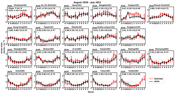
This study evaluates the Geostationary Environment Monitoring Spectrometer (GEMS) HCHO product by comparing its vertical column densities (VCDs) with those of TROPOMI and ground-based observations. Based on some sensitivity tests, obtaining radiance references under clear-sky conditions significantly improves HCHO retrieval quality. GEMS HCHO VCDs captured seasonal and diurnal variations well during the first year of observation, showing consistency with TROPOMI and ground-based observations.
Haklim Choi, Xiong Liu, Ukkyo Jeong, Heesung Chong, Jhoon Kim, Myung Hwan Ahn, Dai Ho Ko, Dong-Won Lee, Kyung-Jung Moon, and Kwang-Mog Lee
Atmos. Meas. Tech., 17, 145–164, https://doi.org/10.5194/amt-17-145-2024, https://doi.org/10.5194/amt-17-145-2024, 2024
Short summary
Short summary
GEMS is the first geostationary satellite to measure the UV--Vis region, and this paper reports the polarization characteristics of GEMS and an algorithm. We develop a polarization correction algorithm optimized for GEMS based on a look-up-table approach that simultaneously considers the polarization of incoming light and polarization sensitivity characteristics of the instrument. Pre-launch polarization error was adjusted close to zero across the spectral range after polarization correction.
Kanghyun Baek, Jae Hwan Kim, Juseon Bak, David P. Haffner, Mina Kang, and Hyunkee Hong
Atmos. Meas. Tech., 16, 5461–5478, https://doi.org/10.5194/amt-16-5461-2023, https://doi.org/10.5194/amt-16-5461-2023, 2023
Short summary
Short summary
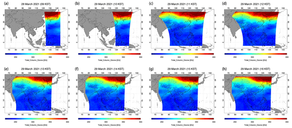
The GEMS mission was the first mission of the geostationary satellite constellation for hourly atmospheric composition monitoring. The GEMS ozone measurements were cross-compared to those of Pandora, OMPS, and TROPOMI satellite sensors and excellent agreement was found. GEMS has proven to be a powerful new instrument for monitoring and assessing the diurnal variation in atmospheric ozone. This experience can be used to advance research with future geostationary environmental satellite missions.
Cited articles
Bajorski, P.: Statistical inference in PCA for hyperspectral images, IEEE J. Sel. Top. Signa., 5, 438–445, https://doi.org/10.1109/JSTSP.2011.2105244, 2011.
Bak, J., Baek, K.-H., Kim, J.-H., Liu, X., Kim, J., and Chance, K.: Cross-evaluation of GEMS tropospheric ozone retrieval performance using OMI data and the use of an ozonesonde dataset over East Asia for validation, Atmos. Meas. Tech., 12, 5201–5215, https://doi.org/10.5194/amt-12-5201-2019, 2019.
Boersma, K. F., Eskes, H. J., and Brinksma, E. J.: Error analysis for
tropospheric NO2 retrieval from space, J. Geophys. Res.-Atmos., 109, D04311, https://doi.org/10.1029/2003jd003962, 2004.
Bovensmann, H., Burrows, J. P., Buchwitz, M., Frerick, J., Noël, S.,
Rozanov, V. v., Chance, K. V., and Goede, A. P. H.: SCIAMACHY: Mission
objectives and measurement modes, J. Atmos. Sci., 56, 127–150,
https://doi.org/10.1175/1520-0469(1999)056<0127:SMOAMM>2.0.CO;2, 1999.
Choi, H., Liu, X., Gonzalez Abad, G., Seo, J., Lee, K.-M., and Kim, J.: A
Fast Retrieval of Cloud Parameters Using a Triplet of Wavelengths of Oxygen
Dimer Band around 477 nm, Remote Sens.-Basel, 13, 152,
https://doi.org/10.3390/rs13010152, 2021.
Cybenko, G.: Approximation by superpositions of a sigmoidal function,
Math. Control Signal., 2, 303–314, https://doi.org/10.1007/BF02551274, 1989.
Fang, H., Liang, S., Townshend, J. R., and Dickinson, R. E.: Spatially and
temporally continuous LAI data sets based on an integrated filtering method:
Examples from North America, Remote Sens. Environ., 112, 75–93,
https://doi.org/10.1016/J.RSE.2006.07.026, 2008.
Fischer, A. D., Downes, T. V., and Leathers, R.: Median spectral-spatial bad
pixel identification and replacement for hyperspectral SWIR sensors, in:
Proceedings of SPIE – Algorithms and Technologies for Multispectral, Hyperspectral, and Ultraspectral Imagery XII, 65651E, https://doi.org/10.1117/12.720050, 2007.
Gewali, U. B., Monteiro, S. T., and Saber, E.: Machine learning based
hyperspectral image analysis: A survey, arXiv [preprint], https://doi.org/10.48550/arXiv.1802.08701, 23 February 2018.
Goetz, A. F. H., Vane, G., Solomon, J. E., and Rock, B. N.: Imaging
spectrometry for earth remote sensing, Science, 228, 1147–1153,
https://doi.org/10.1126/science.228.4704.1147, 1985.
Guo, L., Lei, L., Zeng, Z. C., Zou, P., Liu, D., and Zhang, B.: Evaluation
of spatio-temporal variogram models for mapping Xco2 using satellite
observations: A case study in China, IEEE J. Sel. Top. Appl., 8, 376–385, https://doi.org/10.1109/JSTARS.2014.2363019, 2015.
Han, T., Goodenough, D. G., Dyk, A., and Love, J.: Detection and correction
of abnormal pixels in hyperion images, Int. Geosci. Remote Se., 3, 1327–1330, https://doi.org/10.1109/IGARSS.2002.1026105, 2002.
Hedelt, P., Efremenko, D. S., Loyola, D. G., Spurr, R., and Clarisse, L.: Sulfur dioxide layer height retrieval from Sentinel-5 Precursor/TROPOMI using FP_ILM, Atmos. Meas. Tech., 12, 5503–5517, https://doi.org/10.5194/amt-12-5503-2019, 2019.
Horler, D. N. and Ahern, F. J.: Forestry information content of thematic
mapper data, Int. J. Remote Sens., 7, 405–428,
https://doi.org/10.1080/01431168608954695, 1986.
Hornik, K., Stinchcombe, M., and White, H.: Multilayer feedforward networks
are universal approximators, Neural Networks, 2, 359–366,
https://doi.org/10.1016/0893-6080(89)90020-8, 1989.
Howell, S. B.: CCD imaging, in: Handbook of CCD Astronomy, Cambridge
University Press, Cambridge, 66–101, https://doi.org/10.1017/CBO9780511807909.006, 2006.
Joiner, J., Bhartia, P. K., Cebula, R. P., Hilsenrath, E., McPeters, R. D.,
and Park, H.: Rotational Raman scattering (Ring effect) in satellite
backscatter ultraviolet measurements, Appl. Optics, 34, 4513,
https://doi.org/10.1364/AO.34.004513, 1995.
Joiner, J., Yoshida, Y., Guanter, L., and Middleton, E. M.: New methods for the retrieval of chlorophyll red fluorescence from hyperspectral satellite instruments: simulations and application to GOME-2 and SCIAMACHY, Atmos. Meas. Tech., 9, 3939–3967, https://doi.org/10.5194/amt-9-3939-2016, 2016.
Kang, M., Ahn, M. H., Liu, X., Jeong, U., and Kim, J.: Spectral calibration
algorithm for the geostationary environment monitoring spectrometer (Gems),
Remote Sens.-Basel, 12, 1–17, https://doi.org/10.3390/rs12172846, 2020.
Kang, M., Ahn, M. H., Ko, D. H., Kim, J., Nicks, D., Eo, M., Lee, Y., Moon,
K. J., and Lee, D. W.: Characteristics of the Spectral Response Function of
Geostationary Environment Monitoring Spectrometer Analyzed by Ground and
In-Orbit Measurements, IEEE T. Geosci. Remote, 60, 1–16, https://doi.org/10.1109/TGRS.2021.3091677, 2022.
Katzfuss, M. and Cressie, N.: Spatio-temporal smoothing and EM estimation
for massive remote-sensing data sets, J. Time Ser. Anal., 32, 430–446,
https://doi.org/10.1111/J.1467-9892.2011.00732.X, 2011.
Kieffer, H. H.: Detection and correction of bad pixels in hyperspectral
sensors, in: Proceedings of SPIE – Hyperspectrel Remote Sensing and Applications, 2821, https://doi.org/10.1117/12.257162, 1996.
Kim, G., Choi, Y. S., Park, S. S., and Kim, J.: Effect of solar zenith angle
on satellite cloud retrievals based on O2–O2 absorption band, Int. J. Remote Sens., 42, 4224–4240, https://doi.org/10.1080/01431161.2021.1890267, 2021.
Kim, J., Jeong, U., Ahn, M. H., Kim, J. H., Park, R. J., Lee, H., Song, C.
H., Choi, Y. S., Lee, K. H., Yoo, J. M., Jeong, M. J., Park, S. K., Lee, K.
M., Song, C. K., Kim, S. W., Kim, Y. J., Kim, S. W., Kim, M., Go, S., Liu,
X., Chance, K., Miller, C. C., Al-Saadi, J., Veihelmann, B., Bhartia, P. K.,
Torres, O., Abad, G. G., Haffner, D. P., Ko, D. H., Lee, S. H., Woo, J. H.,
Chong, H., Park, S. S., Nicks, D., Choi, W. J., Moon, K. J., Cho, A., Yoon,
J., Kim, S. kyun, Hong, H., Lee, K., Lee, H., Lee, S., Choi, M., Veefkind,
P., Levelt, P. F., Edwards, D. P., Kang, M., Eo, M., Bak, J., Baek, K.,
Kwon, H. A., Yang, J., Park, J., Han, K. M., Kim, B. R., Shin, H. W., Choi,
H., Lee, E., Chong, J., Cha, Y., Koo, J. H., Irie, H., Hayashida, S., Kasai,
Y., Kanaya, Y., Liu, C., Lin, J., Crawford, J. H., Carmichael, G. R.,
Newchurch, M. J., Lefer, B. L., Herman, J. R., Swap, R. J., Lau, A. K. H.,
Kurosu, T. P., Jaross, G., Ahlers, B., Dobber, M., McElroy, C. T., and Choi,
Y.: New era of air quality monitoring from space: Geostationary environment
monitoring spectrometer (GEMS), B. Am. Meteorol. Soc., 101, E1–E22,
https://doi.org/10.1175/BAMS-D-18-0013.1, 2020.
Kingma, D. P. and Ba, J. L.: Adam: A method for stochastic optimization, arXiv [preprint], https://doi.org/10.48550/arXiv.1412.6980, 22 December 2014.
Le, T., Liu, C., Yao, B., Natraj, V., and Yung, Y. L.: Application of
machine learning to hyperspectral radiative transfer simulations, J. Quant.
Spectrosc. Ra., 246, 106928, https://doi.org/10.1016/j.jqsrt.2020.106928, 2020.
Lee, Y., Ahn, M. H., and Kang, M.: The new potential of deep convective
clouds as a calibration target for a geostationary UV/VIS hyperspectral
spectrometer, Remote Sens.-Basel, 12, 446, https://doi.org/10.3390/rs12030446, 2020.
Li, C., Joiner, J., Krotkov, N. A., and Bhartia, P. K.: A fast and sensitive
new satellite SO2 retrieval algorithm based on principal component analysis:
Application to the ozone monitoring instrument, Geophys. Res. Lett., 40,
6314–6318, https://doi.org/10.1002/2013GL058134, 2013.
Li, C., Joiner, J., Krotkov, N. A., and Dunlap, L.: A new method for global
retrievals of HCHO total columns from the Suomi National Polar-orbiting
Partnership Ozone Mapping and Profiler Suite, Geophys. Res. Lett., 42,
2515–2522, https://doi.org/10.1002/2015GL063204, 2015.
Liu, X., Smith, W. L., Zhou, D. K., and Larar, A.: Principal component-based
radiative transfer model for hyperspectral sensors: Theoretical concept,
Appl, Optics, 45, 201–209, https://doi.org/10.1364/AO.45.000201, 2006.
Llamas, R. M., Guevara, M., Rorabaugh, D., Taufer, M., and Vargas, R.:
Spatial Gap-Filling of ESA CCI Satellite-Derived Soil Moisture Based on
Geostatistical Techniques and Multiple Regression, Remote Sens., 12, 665, https://doi.org/10.3390/RS12040665, 2020.
López-Alonso, J. M. and Alda, J.: Bad pixel identification
by means of principal components analysis, Opt. Eng., 41, 2152,
https://doi.org/10.1117/1.1497397, 2002.
Loyola, D. G., Koukouli, M. E., Valks, P., Balis, D. S., Hao, N., van
Roozendael, M., Spurr, R. J. D., Zimmer, W., Kiemle, S., Lerot, C., and
Lambert, J. C.: The GOME-2 total column ozone product: Retrieval algorithm
and ground-based validation, J. Geophys. Res.-Atmos., 116, 1–11, https://doi.org/10.1029/2010JD014675, 2011.
Loyola, D. G., Gimeno García, S., Lutz, R., Argyrouli, A., Romahn, F., Spurr, R. J. D., Pedergnana, M., Doicu, A., Molina García, V., and Schüssler, O.: The operational cloud retrieval algorithms from TROPOMI on board Sentinel-5 Precursor, Atmos. Meas. Tech., 11, 409–427, https://doi.org/10.5194/amt-11-409-2018, 2018.
Ludewig, A., Kleipool, Q., Bartstra, R., Landzaat, R., Leloux, J., Loots, E., Meijering, P., van der Plas, E., Rozemeijer, N., Vonk, F., and Veefkind, P.: In-flight calibration results of the TROPOMI payload on board the Sentinel-5 Precursor satellite, Atmos. Meas. Tech., 13, 3561–3580, https://doi.org/10.5194/amt-13-3561-2020, 2020.
Manolakis, D., Pieper, M., Truslow, E., Lockwood, R., Weisner, A., Jacobson,
J., and Cooley, T.: Longwave infrared hyperspectral imaging: Principles,
progress, and challenges, IEEE Geosci. Remote Sens. Mag., 7, 72–100,
https://doi.org/10.1109/MGRS.2018.2889610, 2019.
NIER-ESC: GEMS Level 2 products, NIER-ESC [data set], https://nesc.nier.go.kr/product/view/, last access: 12 January 2023.
Nwankpa, C., Ijomah, W., Gachagan, A., and Marshall, S.: Activation functions: Comparison of trends in practice and research for deep learning, arXiv [preprint], https://doi.org/10.48550/arXiv.1811.03378, 8 November 2018.
Pan, C., Zhou, L., Cao, C., Flynn, L., and Beach, E.: Suomi-NPP OMPS Nadir
mapper's operational SDR performance, IEEE T. Geosci. Remote, 57, 1015–1024, https://doi.org/10.1109/TGRS.2018.2864125, 2019.
Schenkeveld, V. M. E., Jaross, G., Marchenko, S., Haffner, D., Kleipool, Q. L., Rozemeijer, N. C., Veefkind, J. P., and Levelt, P. F.: In-flight performance of the Ozone Monitoring Instrument, Atmos. Meas. Tech., 10, 1957–1986, https://doi.org/10.5194/amt-10-1957-2017, 2017.
Schläpfer, D., Nieke, J., and Itten, K. I.: Spatial PSF nonuniformity
effects in airborne pushbroom imaging spectrometry data, IEEE T. Geosci. Remote, 45, 458–468, https://doi.org/10.1109/TGRS.2006.886182, 2007.
Seftor, C. J., Jaross, G., Kowitt, M., Haken, M., Li, J., and Flynn, L. E.:
Postlaunch performance of the Suomi National Polar-orbiting Partnership
Ozone Mapping and Profiler Suite (OMPS) nadir sensors, J. Geophys. Res.-Atmos., 119, 4413–4428, https://doi.org/10.1002/2013JD020472, 2014.
Taylor, M., Kosmopoulos, P. G., Kazadzis, S., Keramitsoglou, I., and
Kiranoudis, C. T.: Neural network radiative transfer solvers for the
generation of high resolution solar irradiance spectra parameterized by
cloud and aerosol parameters, J. Quant. Spectrosc. Ra., 168,
176–192, https://doi.org/10.1016/j.jqsrt.2015.08.018, 2016.
TensorFlow: https://www.tensorflow.org/install/, last access: 12 January 2023.
Wu, W., Liu, X., Xiong, X., Li, Y., Yang, Q., Wu, A., Kizer, S., and Cao,
C.: An Accurate Method for Correcting Spectral Convolution Errors in
Intercalibration of Broadband and Hyperspectral Sensors, J. Geophys. Res.-Atmos., 123, 9238–9255, https://doi.org/10.1029/2018JD028585, 2018.
Yang, M., Khan, F. A., Tian, H., and Liu, Q.: Analysis of the Monthly and
Spring-Neap Tidal Variability of Satellite Chlorophyll-a and Total Suspended
Matter in a Turbid Coastal Ocean Using the DINEOF Method, Remote Sens., 13, 632, https://doi.org/10.3390/RS13040632, 2021.
Zarzalejo, L. F., Ramirez, L., and Polo, J.: Artificial intelligence
techniques applied to hourly global irradiance estimation from
satellite-derived cloud index, Energy, 30, 1685–1697,
https://doi.org/10.1016/j.energy.2004.04.047, 2005.
Zhu, S., Lei, B., and Wu, Y.: Retrieval of hyperspectral surface reflectance
based on machine learning, Remote Sens.-Basel, 10, 1–15,
https://doi.org/10.3390/rs10020323, 2018.
Short summary
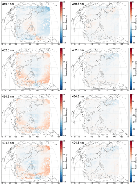
This study aims to verify that a partly defective hyperspectral measurement can be successfully reproduced with concise machine learning models coupled with principal component analysis. Evaluation of the approach is performed with radiances and retrieval results of ozone and cloud properties. Considering that GEMS is the first geostationary UV–VIS hyperspectral spectrometer, we expect our findings can be introduced further to similar geostationary environmental instruments to be launched soon.
This study aims to verify that a partly defective hyperspectral measurement can be successfully...
Special issue