
Articles | Volume 19, issue 21
https://doi.org/10.5194/amt-19-7131-2026
© Author(s) 2026. This work is distributed under
the Creative Commons Attribution 4.0 License.
the Creative Commons Attribution 4.0 License.
https://doi.org/10.5194/amt-19-7131-2026
© Author(s) 2026. This work is distributed under
the Creative Commons Attribution 4.0 License.
the Creative Commons Attribution 4.0 License.
Research article
| Highlight paper
| 
11 Nov 2026
Research article | Highlight paper |
| 11 Nov 2026
| 11 Nov 2026
Facility-scale quantification and monitoring of ammonia (NH3) emissions using ASTER multispectral thermal infrared observations
Lidewij B. Tijhuis
CORRESPONDING AUTHOR

Netherlands Organization for Applied Scientific Research (TNO), Air Quality and Emissions Research (AER), Utrecht, the Netherlands
Tyler Wizenberg
Netherlands Organization for Applied Scientific Research (TNO), Air Quality and Emissions Research (AER), Utrecht, the Netherlands
Enrico Dammers
Netherlands Organization for Applied Scientific Research (TNO), Air Quality and Emissions Research (AER), Utrecht, the Netherlands
Institute of Environmental Science (CML), Leiden University, 2300 RA Leiden, the Netherlands
Related authors
No articles found.
Simeng Li, Enrico Dammers, Beatriz Herrera, Arjo Segers, Mark W. Shephard, Martin Van Damme, Lieven Clarisse, Shelley van der Graaf, Roy Wichink Kruit, and Jan Willem Erisman
EGUsphere, https://doi.org/10.5194/egusphere-2026-4245, https://doi.org/10.5194/egusphere-2026-4245, 2026
This preprint is open for discussion and under review for Geoscientific Instrumentation, Methods and Data Systems (GI).
Short summary
Short summary
Ammonia from agriculture can harm ecosystems and air quality, but tracking emissions accurately is difficult. We developed a method combining in situ measurements and satellite observations to estimate ammonia emissions across the Netherlands. In situ measurement captures local detail while satellites provide broad coverage; combining both improves estimates. We also identified where new measurement stations would most improve emission monitoring, helping guide future network design.
Jun Zhang, Arjan Hensen, Baye Thera, Pim van den Bulk, Daniëlle van Dinther, Ilona Velzeboer, Enrico Dammers, Gerrit Jan de Bruin, Paula Bronsveld, and Martijn Schaap
EGUsphere, https://doi.org/10.5194/egusphere-2026-2838, https://doi.org/10.5194/egusphere-2026-2838, 2026
Short summary
Short summary
We developed a mobile monitoring platform to measure ammonia, methane, and carbon monoxide emissions from farms, traffic, and industry under real-world conditions. During a 160 km campaign in the Netherlands, the system distinguished emission sources and detected several missing from existing inventories. The results show that mobile monitoring can improve emission estimates and support more accurate environmental assessments.
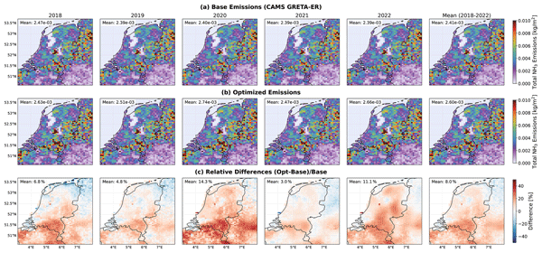
Tyler Wizenberg, Enrico Dammers, Arjo Segers, Mark W. Shephard, Pierre Coheur, Lieven Clarisse, Martin Van Damme, Henk Eskes, Roy Wichink Kruit, Shelley van der Graaf, and Martijn Schaap
Atmos. Chem. Phys., 26, 9589–9623, https://doi.org/10.5194/acp-26-9589-2026, https://doi.org/10.5194/acp-26-9589-2026, 2026
Short summary
Short summary
We combined five years of satellite data on ammonia and nitrogen dioxide concentrations with a regional model to better estimate nitrogen emissions and deposition in the Netherlands. This improved the accuracy of pollution maps and trends, especially in agricultural regions. Our approach helps identify when and where emissions are highest, supporting better air quality management and environmental protection by showing the benefits of using multiple complimentary satellite datasets together.
Beatriz Herrera, Enrico Dammers, Martine De Maziere, Omaira Garcia, Michel Grutter, James W. Hannigan, Dylan B. A. Jones, Nicholas Jones, Emmanuel Mahieu, Maria Makarova, Kazuyuki Miyazaki, Isamu Morino, Isao Murata, Ivan Ortega, Mathias Palm, Anatoly Poverovskii, Takashi Sekiya, Dan Smale, Hannah Sill, Wolfgang Stremme, Ralf Sussmann, Geoffrey Toon, Corinne Vigouroux, Wei Wang, Tyler Wizenberg, and Kimberly Strong
EGUsphere, https://doi.org/10.5194/egusphere-2026-3138, https://doi.org/10.5194/egusphere-2026-3138, 2026
Short summary
Short summary
This work investigates how atmospheric ammonia changes over time using long-term observations and simulations at locations around the world. While its main sources are related to agriculture, wildfires, vehicles, and volcanoes also contribute. The results show that ammonia levels vary strongly during the day and across seasons, and are rising at most locations. These findings improve our understanding of air pollution and its impacts.
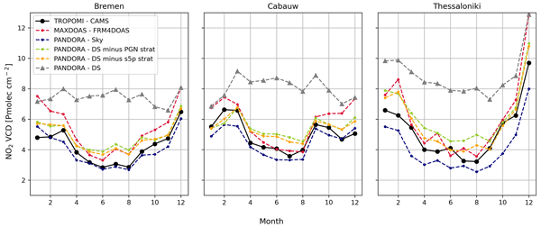
Felipe Cifuentes, Henk Eskes, Ankie Piters, Julian Gomez, John Douros, Gaia Pinardi, Martina M. Friedrich, Enrico Dammers, Manuel Gebetsberger, and K. Folkert Boersma
Atmos. Meas. Tech., 19, 2437–2477, https://doi.org/10.5194/amt-19-2437-2026, https://doi.org/10.5194/amt-19-2437-2026, 2026
Short summary
Short summary
Satellite NO2 data are essential for monitoring air pollution, but they are affected by several sources of uncertainty. This study evaluates the major error contributors in TROPOMI (TROPOspheric Monitoring Instrument) NO2 retrievals by analyzing each retrieval step and comparing with ground-based observations. Key findings include biases in the separation of stratospheric and tropospheric NO2, representation and smoothing errors, and substantial variability among the ground-based instruments used for validation.
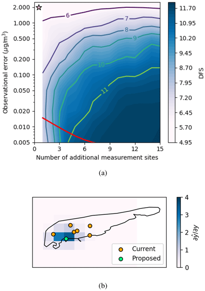
Simeng Li, Enrico Dammers, Arjo Segers, and Jan Willem Erisman
Atmos. Chem. Phys., 25, 15593–15611, https://doi.org/10.5194/acp-25-15593-2025, https://doi.org/10.5194/acp-25-15593-2025, 2025
Short summary
Short summary
Between 2019 and 2022, a notable reduction in livestock numbers has been observed on Schiermonnikoog, a small island in the north of the Netherlands. We have assessed ammonia emissions using real-world measurements on the island, demonstrated emission decrease, and proposed a network to improve emission monitoring.
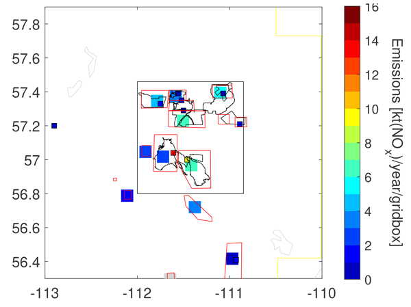
Chris A. McLinden, Debora Griffin, Vitali Fioletov, Junhua Zhang, Enrico Dammers, Cristen Adams, Mallory Loria, Nickolay Krotkov, and Lok N. Lamsal
Atmos. Chem. Phys., 25, 6093–6120, https://doi.org/10.5194/acp-25-6093-2025, https://doi.org/10.5194/acp-25-6093-2025, 2025
Short summary
Short summary
The Ozone Monitoring Instrument (OMI) was used to understand the evolution of NOx emissions from the Canadian oil sands. OMI NO2 combined with winds and reported stack emissions found emissions from the heavy-hauler mine fleet have remained flat since 2005, whereas the total oil sands mined have more than doubled. This difference is a result of emissions standards that limit NOx emissions becoming more stringent over this period, confirming the efficacy of the policy enacting these standards.
Tycho Jongenelen, Margreet van Zanten, Enrico Dammers, Roy Wichink Kruit, Arjan Hensen, Leon Geers, and Jan Willem Erisman
Atmos. Chem. Phys., 25, 4943–4963, https://doi.org/10.5194/acp-25-4943-2025, https://doi.org/10.5194/acp-25-4943-2025, 2025
Short summary
Short summary
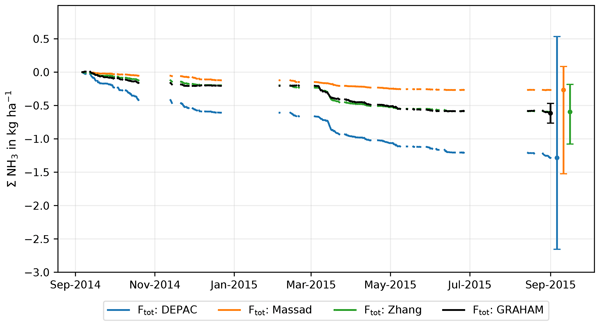
This article compares three ammonia (NH3) deposition models in a dune ecosystem and investigates the uncertainty of these models. The Zhang model aligned best with the measurements, whereas the DEPAC (DEPosition of Acidifying Compounds) and Massad models overestimated and underestimated the NH3 deposition respectively. The study found that NH3 exchange with wet plant leaves was an important but uncertain process. It offers recommendations to improve future models and suggests measurements to lower the existing uncertainty.
Felipe Cifuentes, Henk Eskes, Enrico Dammers, Charlotte Bryan, and Folkert Boersma
Geosci. Model Dev., 18, 621–649, https://doi.org/10.5194/gmd-18-621-2025, https://doi.org/10.5194/gmd-18-621-2025, 2025
Short summary
Short summary
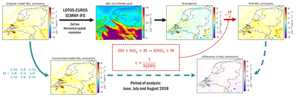
We tested the capability of the flux divergence approach (FDA) to reproduce known NOx emissions using synthetic NO2 satellite column retrievals from high-resolution model simulations. The FDA accurately reproduced NOx emissions when column observations were limited to the boundary layer and when the variability of the NO2 lifetime, the NOx : NO2 ratio, and NO2 profile shapes were correctly modeled. This introduces strong model dependency, reducing the simplicity of the original FDA formulation.
Jieying Ding, Ronald van der A, Henk Eskes, Enrico Dammers, Mark Shephard, Roy Wichink Kruit, Marc Guevara, and Leonor Tarrason
Atmos. Chem. Phys., 24, 10583–10599, https://doi.org/10.5194/acp-24-10583-2024, https://doi.org/10.5194/acp-24-10583-2024, 2024
Short summary
Short summary
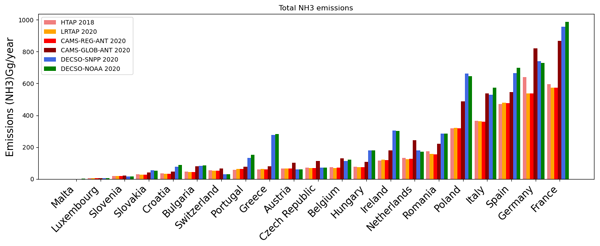
Here we applied the existing Daily Emissions Constrained by Satellite Observations (DECSO) inversion algorithm to NH3 observations from the CrIS satellite instrument to estimate NH3 emissions. As NH3 in the atmosphere is influenced by NOx, we implemented DECSO to estimate NOx and NH3 emissions simultaneously. The emissions are derived over Europe for 2020 at a spatial resolution of 0.2° using daily observations from CrIS and TROPOMI. Results are compared to bottom-up emission inventories.
Debora Griffin, Jack Chen, Kerry Anderson, Paul Makar, Chris A. McLinden, Enrico Dammers, and Andre Fogal
Atmos. Chem. Phys., 24, 10159–10186, https://doi.org/10.5194/acp-24-10159-2024, https://doi.org/10.5194/acp-24-10159-2024, 2024
Short summary
Short summary
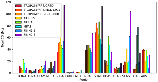
Satellite-derived CO emissions provide new insights into the understanding of global CO emission rates from wildfires. We use TROPOMI satellite data to create a global inventory database of wildfire CO emissions. These satellite-derived wildfire emissions are used for the evaluation and improvement of existing fire emission inventories and to examine how the wildfire CO emissions have changed over the past 2 decades.
Enrico Dammers, Janot Tokaya, Christian Mielke, Kevin Hausmann, Debora Griffin, Chris McLinden, Henk Eskes, and Renske Timmermans
Geosci. Model Dev., 17, 4983–5007, https://doi.org/10.5194/gmd-17-4983-2024, https://doi.org/10.5194/gmd-17-4983-2024, 2024
Short summary
Short summary
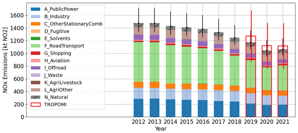
Nitrogen dioxide (NOx) is produced by sources such as industry and traffic and is directly linked to negative impacts on health and the environment. The current construction of emission inventories to keep track of NOx emissions is slow and time-consuming. Satellite measurements provide a way to quickly and independently estimate emissions. In this study, we apply a consistent methodology to derive NOx emissions over Germany and illustrate the value of having such a method for fast projections.
Tobias Christoph Valentin Werner Riess, Klaas Folkert Boersma, Ward Van Roy, Jos de Laat, Enrico Dammers, and Jasper van Vliet
Atmos. Meas. Tech., 16, 5287–5304, https://doi.org/10.5194/amt-16-5287-2023, https://doi.org/10.5194/amt-16-5287-2023, 2023
Short summary
Short summary
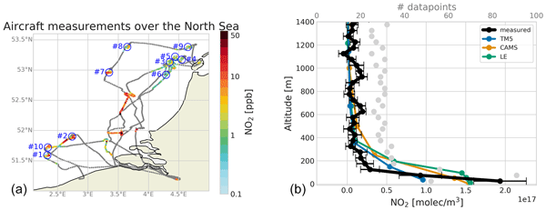
Satellite retrievals of trace gases require prior knowledge of the vertical distribution of the pollutant, which is usually obtained from models. Using aircraft-measured vertical NO2 profiles over the North Sea in summer 2021, we evaluate the Transport Model 5 profiles used in the TROPOMI NO2 retrieval. We conclude that driven by the low horizontal resolution and the overestimated vertical mixing, resulting NO2 columns are 20 % too low. This has important implications for emission estimates.
Nasrin Mostafavi Pak, Jacob K. Hedelius, Sébastien Roche, Liz Cunningham, Bianca Baier, Colm Sweeney, Coleen Roehl, Joshua Laughner, Geoffrey Toon, Paul Wennberg, Harrison Parker, Colin Arrowsmith, Joseph Mendonca, Pierre Fogal, Tyler Wizenberg, Beatriz Herrera, Kimberly Strong, Kaley A. Walker, Felix Vogel, and Debra Wunch
Atmos. Meas. Tech., 16, 1239–1261, https://doi.org/10.5194/amt-16-1239-2023, https://doi.org/10.5194/amt-16-1239-2023, 2023
Short summary
Short summary
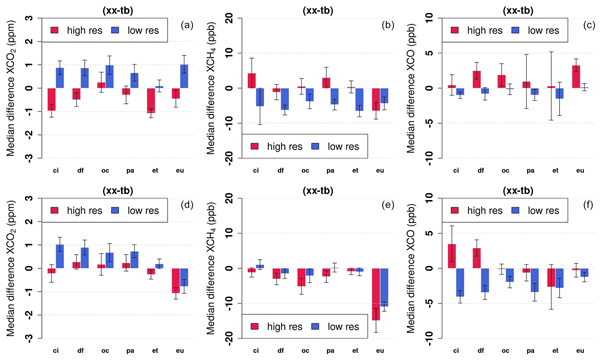
Ground-based remote sensing instruments in the Total Carbon Column Observing Network (TCCON) measure greenhouse gases in the atmosphere. Consistency between TCCON measurements is crucial to accurately infer changes in atmospheric composition. We use portable remote sensing instruments (EM27/SUN) to evaluate biases between TCCON stations in North America. We also improve the retrievals of EM27/SUN instruments and evaluate the previous (GGG2014) and newest (GGG2020) retrieval algorithms.
Ali Jalali, Kaley A. Walker, Kimberly Strong, Rebecca R. Buchholz, Merritt N. Deeter, Debra Wunch, Sébastien Roche, Tyler Wizenberg, Erik Lutsch, Erin McGee, Helen M. Worden, Pierre Fogal, and James R. Drummond
Atmos. Meas. Tech., 15, 6837–6863, https://doi.org/10.5194/amt-15-6837-2022, https://doi.org/10.5194/amt-15-6837-2022, 2022
Short summary
Short summary
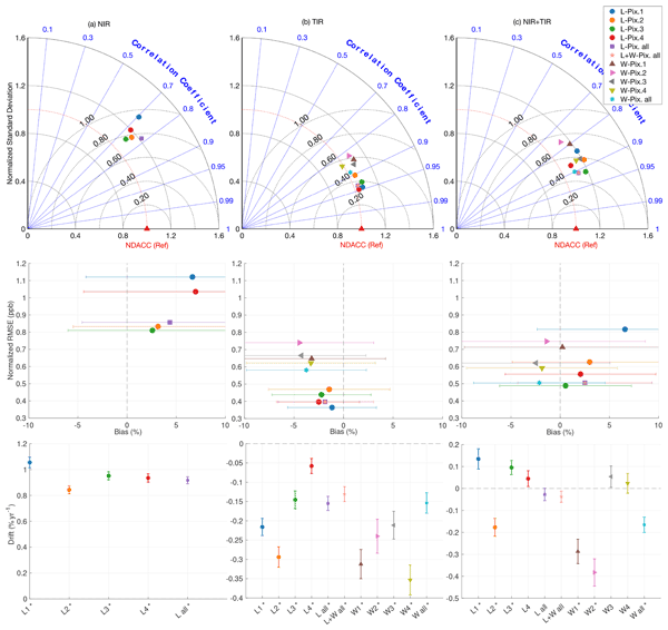
This study validates MOPITT version 8 carbon monoxide measurements over the Canadian high Arctic for the period 2006 to 2019. The MOPITT products from different detector pixels and channels are compared with ground-based measurements from the Polar Environment Atmospheric Research Laboratory (PEARL) in Eureka, Nunavut, Canada. These results show good consistency between the satellite and ground-based measurements and provide guidance on the usage of these MOPITT data at high latitudes.
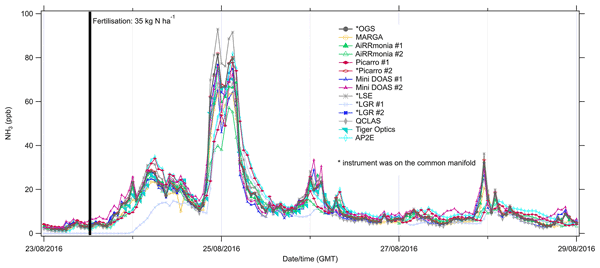
Marsailidh M. Twigg, Augustinus J. C. Berkhout, Nicholas Cowan, Sabine Crunaire, Enrico Dammers, Volker Ebert, Vincent Gaudion, Marty Haaima, Christoph Häni, Lewis John, Matthew R. Jones, Bjorn Kamps, John Kentisbeer, Thomas Kupper, Sarah R. Leeson, Daiana Leuenberger, Nils O. B. Lüttschwager, Ulla Makkonen, Nicholas A. Martin, David Missler, Duncan Mounsor, Albrecht Neftel, Chad Nelson, Eiko Nemitz, Rutger Oudwater, Celine Pascale, Jean-Eudes Petit, Andrea Pogany, Nathalie Redon, Jörg Sintermann, Amy Stephens, Mark A. Sutton, Yuk S. Tang, Rens Zijlmans, Christine F. Braban, and Bernhard Niederhauser
Atmos. Meas. Tech., 15, 6755–6787, https://doi.org/10.5194/amt-15-6755-2022, https://doi.org/10.5194/amt-15-6755-2022, 2022
Short summary
Short summary
Ammonia (NH3) gas in the atmosphere impacts the environment, human health, and, indirectly, climate. Historic NH3 monitoring was labour intensive, and the instruments were complicated. Over the last decade, there has been a rapid technology development, including “plug-and-play” instruments. This study is an extensive field comparison of the currently available technologies and provides evidence that for routine monitoring, standard operating protocols are required for datasets to be comparable.
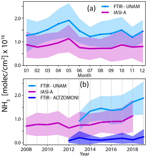
Beatriz Herrera, Alejandro Bezanilla, Thomas Blumenstock, Enrico Dammers, Frank Hase, Lieven Clarisse, Adolfo Magaldi, Claudia Rivera, Wolfgang Stremme, Kimberly Strong, Camille Viatte, Martin Van Damme, and Michel Grutter
Atmos. Chem. Phys., 22, 14119–14132, https://doi.org/10.5194/acp-22-14119-2022, https://doi.org/10.5194/acp-22-14119-2022, 2022
Short summary
Short summary
This work investigates atmospheric ammonia (NH3), a key trace gas with consequences for the environment and human health, in Mexico City. The results from the ground-based and satellite instruments show the variability and spatial distribution of NH3 over this region. NH3 in Mexico City has been increasing for the past 10 years and most of its sources are urban. This work contributes to a better understanding of NH3 sources and variability in urban and remote areas.
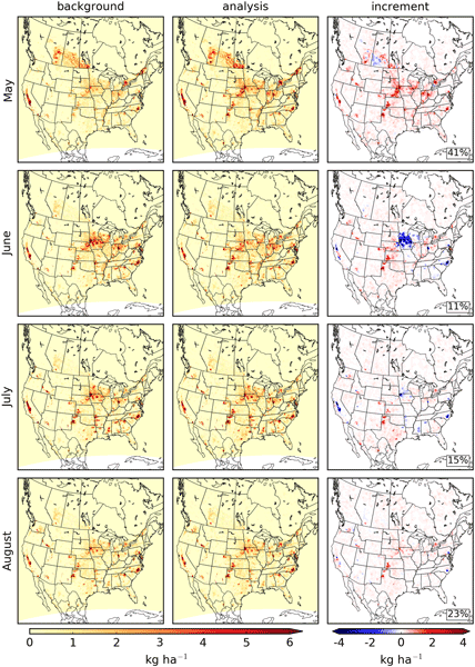
Michael Sitwell, Mark W. Shephard, Yves Rochon, Karen Cady-Pereira, and Enrico Dammers
Atmos. Chem. Phys., 22, 6595–6624, https://doi.org/10.5194/acp-22-6595-2022, https://doi.org/10.5194/acp-22-6595-2022, 2022
Short summary
Short summary
Observations of ammonia made using the satellite-borne CrIS instrument were used to improve the ammonia emissions used in the GEM-MACH model. These observations were used to refine estimates of the monthly mean ammonia emissions over North America for May to August 2016. The updated ammonia emissions reduced biases of GEM-MACH surface ammonia fields with surface observations and showed some improvements in the forecasting of species involved in inorganic particulate matter formation.
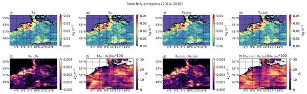
Shelley van der Graaf, Enrico Dammers, Arjo Segers, Richard Kranenburg, Martijn Schaap, Mark W. Shephard, and Jan Willem Erisman
Atmos. Chem. Phys., 22, 951–972, https://doi.org/10.5194/acp-22-951-2022, https://doi.org/10.5194/acp-22-951-2022, 2022
Short summary
Short summary
CrIS NH3 satellite observations are assimilated into the LOTOS-EUROS model using two different methods. In the first method the data are used to fit spatially varying NH3 emission time factors. In the second method a local ensemble transform Kalman filter is used. Compared to in situ observations, combining both methods led to the most significant improvements in the modeled concentrations and deposition, illustrating the usefulness of CrIS NH3 to improve the spatiotemporal distribution of NH3.
Debora Griffin, Chris A. McLinden, Enrico Dammers, Cristen Adams, Chelsea E. Stockwell, Carsten Warneke, Ilann Bourgeois, Jeff Peischl, Thomas B. Ryerson, Kyle J. Zarzana, Jake P. Rowe, Rainer Volkamer, Christoph Knote, Natalie Kille, Theodore K. Koenig, Christopher F. Lee, Drew Rollins, Pamela S. Rickly, Jack Chen, Lukas Fehr, Adam Bourassa, Doug Degenstein, Katherine Hayden, Cristian Mihele, Sumi N. Wren, John Liggio, Ayodeji Akingunola, and Paul Makar
Atmos. Meas. Tech., 14, 7929–7957, https://doi.org/10.5194/amt-14-7929-2021, https://doi.org/10.5194/amt-14-7929-2021, 2021
Short summary
Short summary
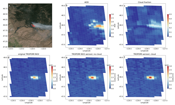
Satellite-derived NOx emissions from biomass burning are estimated with TROPOMI observations. Two common emission estimation methods are applied, and sensitivity tests with model output were performed to determine the accuracy of these methods. The effect of smoke aerosols on TROPOMI NO2 columns is estimated and compared to aircraft observations from four different aircraft campaigns measuring biomass burning plumes in 2018 and 2019 in North America.
Jonathan E. Hickman, Niels Andela, Enrico Dammers, Lieven Clarisse, Pierre-François Coheur, Martin Van Damme, Courtney A. Di Vittorio, Money Ossohou, Corinne Galy-Lacaux, Kostas Tsigaridis, and Susanne E. Bauer
Atmos. Chem. Phys., 21, 16277–16291, https://doi.org/10.5194/acp-21-16277-2021, https://doi.org/10.5194/acp-21-16277-2021, 2021
Short summary
Short summary
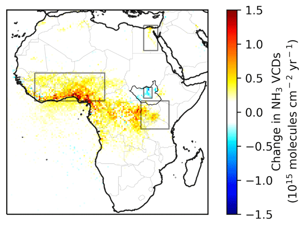
Ammonia (NH3) gas emitted from soils and biomass burning contributes to particulate air pollution. We used satellite observations of the atmosphere over Africa to show that declines in NH3 concentrations over South Sudan's Sudd wetland in 2008–2017 are related to variation in wetland extent. We also find NH3 concentrations increased in West Africa as a result of biomass burning and increased in the Lake Victoria region, likely due to agricultural expansion and intensification.
Cited articles
Barrett, A., Battisto, C., Bourbeau, J., Carroll, I., Daniels, C., Fisher, M., Kaufman, D., Kennedy, J. H., Lopez, L., Lowndes, J., Scheick, J., Steiker, A., and Varghese, S.: earthaccess, Zenodo [data set], https://doi.org/10.5281/zenodo.8365009, 2026. a
Bobbink, R., Hornung, M., and Roelofs, J. G. M.: The effects of air borne nitrogen pollutants on species diversity in natural and semi natural European vegetation, Journal of Ecology, 86, 717–738, 1998. a
Brunekreef, B. and Holgate, S. T.: Air pollution and health, Lancet, 360, 1233–1242, 2002. a
Clarisse, L., Clerbaux, C., Franco, B., Hadji-Lazaro, J., Whitburn, S., Kopp, A., Hurtmans, D., and Coheur, P.-F.: A decadal data set of global atmospheric dust retrieved from IASI satellite measurements, J. Geophys. Res.-Atmos., 124, 1618–1647, 2019. a
Clarisse, L., Franco, B., Van Damme, M., Di Gioacchino, T., Hadji-Lazaro, J., Whitburn, S., Noppen, L., Hurtmans, D., Clerbaux, C., and Coheur, P.: The IASI NH3 version 4 product: averaging kernels and improved consistency, Atmos. Meas. Tech., 16, 5009–5028, https://doi.org/10.5194/amt-16-5009-2023, 2023. a
Dammers, E., McLinden, C. A., Griffin, D., Shephard, M. W., Van Der Graaf, S., Lutsch, E., Schaap, M., Gainairu-Matz, Y., Fioletov, V., Van Damme, M., Whitburn, S., Clarisse, L., Cady-Pereira, K., Clerbaux, C., Coheur, P. F., and Erisman, J. W.: NH3 emissions from large point sources derived from CrIS and IASI satellite observations, Atmos. Chem. Phys., 19, 12261–12293, https://doi.org/10.5194/acp-19-12261-2019, 2019. a, b, c, d, e, f, g, h, i, j, k, l
De Vries, W., Hettelingh, J.-P., and Posch, M.: Critical loads and dynamic risk assessments: Nitrogen, acidity and metals in terrestrial and aquatic ecosystems, Vol. 25, Springer, https://doi.org/10.1007/978-94-017-9508-1, 2015. a
Di Gioacchino, T., Clarisse, L., Noppen, L., Van Damme, M., Bauduin, S., and Coheur, P.: Spatial and temporal variations of thermal contrast in the planetary boundary layer, Journal of Remote Sensing, 4, 0142, https://doi.org/10.34133/remotesensing.0142 2024. a
Erisman, J. W., Sutton, M. A., Galloway, J., Klimont, Z., and Winiwarter, W.: How a century of ammonia synthesis changed the world, Nat. Geosci., 1, 636–639, 2008. a
European Environment Agency: Industrial reporting under the Industrial Emissions Directive 2010/75/EU and European Pollutant Release and Transfer Register Regulation (EC) No 166/2006, https://doi.org/10.2909/3bbf28cb-70e8-4073-8fe9-8c1d9c513f52, 2021. a, b
Fisher, J. B., Lee, B., Purdy, A. J., et al.: ECOSTRESS: NASA's next generation mission to measure evapotranspiration from the international space station, Water Resour. Res., 56, e2019WR026058, https://doi.org/10.1029/2019WR026058, 2020. a
Fowler, D., Pilegaard, K., Sutton, M. A., Ambus, P., Raivonen, M., Duyzer, J., Simpson, D., Fagerli, H., Fuzzi, S., and Schjoerring, J. K.: Atmospheric composition change: ecosystems–atmosphere interactions, Atmos. Environ., 43, 5193–5267, 2009. a
Frankenberg, C., Thorpe, A. K., Thompson, D. R., Hulley, G., Kort, E. A., Vance, N., Borchardt, J., Krings, T., Gerilowski, K., Sweeney, C., Conley, S., Bue, B. D., Aubrey, A. D., Hook, S., and Green, R. O.: Airborne methane remote measurements reveal heavy-tail flux distribution in Four Corners region, P. Natl. Acad. Sci. USA, 113, 9734–9739, 2016. a, b
Galloway, J. N., Aber, J. D., Erisman, J. W., Seitzinger, S. P., Howarth, R. W., Cowling, E. B., and Cosby, B. J.: The nitrogen cascade, Bioscience, 53, 341–356, 2003. a
Gillespie, A. R., Abbott, E. A., Gilson, L., Hulley, G., Jiménez-Muñoz, J.-C., and Sobrino, J. A.: Residual errors in ASTER temperature and emissivity standard products AST08 and AST05, Remote Sens. Environ., 115, 3681–3694, 2011. a
Ginoux, P., Prospero, J. M., Gill, T. E., Hsu, N. C., and Zhao, M.: Global-scale attribution of anthropogenic and natural dust sources and their emission rates based on MODIS Deep Blue aerosol products, Rev. Geophys., 50, https://doi.org/10.1029/2012RG000388, 2012. a
Gorroño, J., Varon, D. J., Irakulis-Loitxate, I., and Guanter, L.: Understanding the potential of Sentinel-2 for monitoring methane point emissions, Atmos. Meas. Tech., 16, 89–107, https://doi.org/10.5194/amt-16-89-2023, 2023. a
Goudar, M., Anema, J. C. S., Kumar, R., Borsdorff, T., and Landgraf, J.: Plume detection and emission estimate for biomass burning plumes from TROPOMI carbon monoxide observations using APE v1.1, Geosci. Model Dev., 16, 4835–4852, https://doi.org/10.5194/gmd-16-4835-2023, 2023. a
Han, Y., Revercomb, H., Cromp, M., Gu, D., Johnson, D., Mooney, D., Scott, D., Strow, L., Bingham, G., Borg, L., Chen, Y., DeSlover, D., Esplin, M., Hagan, D., Jin, X., Knuteson, R., Motteler, H., Predina, J., Suwinski, L., Taylor, J., Tobin, D., Tremblay, D., Wang, C., Wang, L., Wang, L., and Zavyalov, V.: Suomi NPP CrIS measurements, sensor data record algorithm, calibration and validation activities, and record data quality, J. Geophys. Res.-Atmos., 118, 12–734, 2013. a
Hilton, F., Armante, R., August, T., et al.: Hyperspectral Earth observation from IASI: five years of accomplishments, B. Am. Meteorol. Soc., 93, 347–370, 2012. a
Janssens-Maenhout, G., Crippa, M., Guizzardi, D., Dentener, F., Muntean, M., Pouliot, G., Keating, T., Zhang, Q., Kurokawa, J., Wankmüller, R., Denier van der Gon, H., Kuenen, J. J. P., Klimont, Z., Frost, G., Darras, S., Koffi, B., and Li, M.: HTAP_v2.2: a mosaic of regional and global emission grid maps for 2008 and 2010 to study hemispheric transport of air pollution, Atmos. Chem. Phys., 15, 11411–11432, https://doi.org/10.5194/acp-15-11411-2015, 2015. a, b
Karra, K., Kontgis, C., Statman-Weil, Z., Mazzariello, J. C., Mathis, M., and Brumby, S. P.: Global Land Use/Land Cover with Sentinel-2 and Deep Learning, in: IGARSS 2021–2021 IEEE International Geoscience and Remote Sensing Symposium, IEEE, https://doi.org/10.1109/IGARSS47720.2021.9553499, 4704–4707, 2021. a
Kochanov, R., Gordon, I., Rothman, L., Wcisło, P., Hill, C., and Wilzewski, J.: HITRAN Application Programming Interface (HAPI): a comprehensive approach to working with spectroscopic data, J. Quant. Spectrosc. Ra., 177, 15–30, https://doi.org/10.1016/j.jqsrt.2016.03.005, 2016. a, b
Kuai, L., Kalashnikova, O. V., Hopkins, F. M., Hulley, G. C., Lee, H., Garay, M. J., Duren, R. M., Worden, J. R., and Hook, S. J.: Quantification of ammonia emissions with high spatial resolution thermal infrared observations from the hyperspectral thermal emission spectrometer (HyTES) airborne instrument, IEEE J. Sel. Top. Appl., 12, 4798–4812, 2019. a
Kuenen, J., Dellaert, S., Visschedijk, A., Jalkanen, J.-P., Super, I., and Denier van der Gon, H.: CAMS-REG-v4: a state-of-the-art high-resolution European emission inventory for air quality modelling, Earth Syst. Sci. Data, 14, 491–515, https://doi.org/10.5194/essd-14-491-2022, 2022. a
NASA JPL: ASTER Global Emissivity Dataset, 100-meter, HDF5, NASA Land Processes Distributed Active Archive Center [data set], https://doi.org/10.5067/COMMUNITY/ ASTER_GED/AG100.003, 2014. a, b
NASA/METI/AIST/Japan Spacesystems and U.S./Japan ASTER Science Team: ASTER L2 Surface Emissivity V004, NASA Land Processes Distributed Active Archive Center [data set], https://doi.org/10.5067/ASTER/AST_05.004, 2025a. a
NASA/METI/AIST/Japan Spacesystems and U.S./Japan ASTER Science Team: ASTER L2 Surface Kinetic Temperature V004, NASA Land Processes Distributed Active Archive Center [data set], https://doi.org/10.5067/ASTER/AST_08.004, 2025b. a
NASA/METI/AIST/Japan Spacesystems and U.S./Japan ASTER Science Team: ASTER L1B Registered Radiance at the Sensor V004, NASA Land Processes Distributed Active Archive Center [data set], https://doi.org/10.5067/ASTER/AST_L1B.004, 2025c. a
Noppen, L., Clarisse, L., Tack, F., Ruhtz, T., Merlaud, A., Van Damme, M., Van Roozendael, M., Schuettemeyer, D., and Coheur, P.: Constraining industrial ammonia emissions using hyperspectral infrared imaging, Remote Sens. Environ., 291, 113559, https://doi.org/10.1016/j.rse.2023.113559, 2023. a, b, c, d, e, f, g
Noppen, L., Clarisse, L., Tack, F., Ruhtz, T., Van Damme, M., Van Roozendael, M., Schuettemeyer, D., and Coheur, P.: Towards a low-resolution infrared sounder for monitoring atmospheric ammonia (NH3) at high spatial resolution, Atmos. Meas. Tech., 18, 4183–4205, https://doi.org/10.5194/amt-18-4183-2025, 2025. a
Reuter, D. C., Richardson, C. M., Pellerano, F. A., Irons, J. R., Allen, R. G., Anderson, M., Jhabvala, M. D., Lunsford, A. W., Montanaro, M., Smith, R. L., Tesfaye, Z., and Thome, K. J.: The Thermal Infrared Sensor (TIRS) on Landsat 8: design overview and pre-launch characterization, Remote Sens.-Basel, 7, 1135–1153, 2015. a
Schep, C., Van Dooren, H., Mosquera, J., Van Well, E., Keuskamp, J., and Ogink, N.: Monitoring van methaan-, ammoniak-en lachgasemissies uit melkveestallen: Praktijkmetingen in de periode oktober 2018-oktober 2020, https://doi.org/10.18174/576706, 2022. a
Shephard, M. W., Dammers, E., Cady-Pereira, K. E., Kharol, S. K., Thompson, J., Gainariu-Matz, Y., Zhang, J., McLinden, C. A., Kovachik, A., Moran, M., Bittman, S., Sioris, C. E., Griffin, D., Alvarado, M. J., Lonsdale, C., Savic-Jovcic, V., and Zheng, Q.: Ammonia measurements from space with the Cross-track Infrared Sounder: characteristics and applications, Atmos. Chem. Phys., 20, 2277–2302, https://doi.org/10.5194/acp-20-2277-2020, 2020. a
Skjøth, C. A. and Geels, C.: The effect of climate and climate change on ammonia emissions in Europe, Atmos. Chem. Phys., 13, 117–128, https://doi.org/10.5194/acp-13-117-2013, 2013. a
Someya, Y., Imasu, R., Shiomi, K., and Saitoh, N.: Atmospheric ammonia retrieval from the TANSO-FTS/GOSAT thermal infrared sounder, Atmos. Meas. Tech., 13, 309–321, https://doi.org/10.5194/amt-13-309-2020, 2020. a
Stein, A. F., Draxler, R. R., Rolph, G. D., Stunder, B. J., Cohen, M. D., and Ngan, F.: NOAA's HYSPLIT atmospheric transport and dispersion modeling system, B. Am. Meteorol. Soc., 96, 2059–2077, 2015. a
Van Damme, M., Clarisse, L., Heald, C. L., Hurtmans, D., Ngadi, Y., Clerbaux, C., Dolman, A. J., Erisman, J. W., and Coheur, P. F.: Global distributions, time series and error characterization of atmospheric ammonia (NH3) from IASI satellite observations, Atmos. Chem. Phys., 14, 2905–2922, https://doi.org/10.5194/acp-14-2905-2014, 2014. a
Varon, D. J., Jacob, D. J., McKeever, J., Jervis, D., Durak, B. O. A., Xia, Y., and Huang, Y.: Quantifying methane point sources from fine-scale satellite observations of atmospheric methane plumes, Atmos. Meas. Tech., 11, 5673–5686, https://doi.org/10.5194/amt-11-5673-2018, 2018. a, b, c, d, e, f, g, h
Varon, D. J., Jervis, D., McKeever, J., Spence, I., Gains, D., and Jacob, D. J.: High-frequency monitoring of anomalous methane point sources with multispectral Sentinel-2 satellite observations, Atmos. Meas. Tech., 14, 2771–2785, https://doi.org/10.5194/amt-14-2771-2021, 2021. a
Varon, D. J., Jervis, D., Pandey, S., Gallardo, S. L., Balasus, N., Yang, L. H., and Jacob, D. J.: Quantifying NOx point sources with Landsat and Sentinel-2 satellite observations of NO2 plumes, P. Natl. Acad. Sci. USA, 121, e2317077121, https://doi.org/10.1073/pnas.2317077121 2024. a
Yamaguchi, Y., Kahle, A. B., Tsu, H., Kawakami, T., and Pniel, M.: Overview of Advanced Spaceborne Thermal Emission and Reflection Radiometer (ASTER), IEEE T. Geosci. Remote, 36, 1062–1071, 1998. a
Editorial statement
This study shows how satellite observations can identify and quantify ammonia emissions at the scale of individual facilities. By extending this capability to widely available multispectral thermal-infrared instruments, the work offers a potentially scalable approach for monitoring an important air pollutant and supporting emission-reduction policies.
This study shows how satellite observations can identify and quantify ammonia emissions at the...
Short summary
Ammonia is an air pollutant that affects human health, ecosystems, and climate, but satellite measurements usually cannot identify emissions from individual facilities. We show that high‑resolution thermal infrared images can detect ammonia plumes at a much finer scale than existing satellites. This enables clearer identification of industrial sources and provides new opportunities for improved emission estimates and the design of future satellite missions.
Ammonia is an air pollutant that affects human health, ecosystems, and climate, but satellite...


Altmetrics
Final-revised paper
Preprint