
Articles | Volume 19, issue 22
https://doi.org/10.5194/amt-19-7627-2026
© Author(s) 2026. This work is distributed under
the Creative Commons Attribution 4.0 License.
the Creative Commons Attribution 4.0 License.
https://doi.org/10.5194/amt-19-7627-2026
© Author(s) 2026. This work is distributed under
the Creative Commons Attribution 4.0 License.
the Creative Commons Attribution 4.0 License.
Research article
| 
19 Nov 2026
Research article |
| 19 Nov 2026
| 19 Nov 2026
Machine-learning-based approach for solar radiation model prediction error identification, attribution and correction

Finnish Meteorological Institute, Atmospheric Research Centre of Eastern Finland, Kuopio, Finland
Jorge Lezaca
German Aerospace Center (DLR), Institute of Networked Energy Systems, Oldenburg, Germany
Yves-Marie Saint-Drenan
Mines Paris, Université PSL, Centre Observation Impacts Energie, Sophia Antipolis, France
Marion Schroedter-Homscheidt
German Aerospace Center (DLR), Institute of Networked Energy Systems, Oldenburg, Germany
Antti Arola
Finnish Meteorological Institute, Atmospheric Research Centre of Eastern Finland, Kuopio, Finland
Related authors
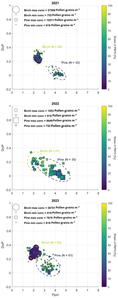
Maria Christina Gatou, Antti Lipponen, Ari Leskinen, Petri Tiitta, Maria Filioglou, Xiaoxia Shang, Sanna Pätsi, Annika Saarto, Marjut Roponen, Elina Giannakaki, and Mika Komppula
Atmos. Meas. Tech., 19, 7387–7401, https://doi.org/10.5194/amt-19-7387-2026, https://doi.org/10.5194/amt-19-7387-2026, 2026
Short summary
Short summary
We investigate the pollen distribution at different heights using measurements from ground level up to 272 meters in eastern Finland. By combining optical pollen sensors with traditional monitoring methods and atmospheric model predictions, we examined how pollen concentrations vary with height. The results show that pollen concentrations decrease with altitude and that optical sensors combined with machine learning can identify dominant pollen types for continuous pollen monitoring.
Kanika Taneja, Silvia M. Calderón, Harri Kokkola, Juha Tonttila, Sami Romakkaniemi, Seethala Chellappan, Antti Arola, Antti Lipponen, Taina Yli-Juuti, Snehitha M. Kommula, Tuukka Petäjä, Markku Kulmala, and Tero Mielonen
EGUsphere, https://doi.org/10.5194/egusphere-2026-4750, https://doi.org/10.5194/egusphere-2026-4750, 2026
Short summary
Short summary
Vegetation can cool the climate by releasing gases that form aerosols, which scatter sunlight and brighten clouds. To quantify this feedback in Finland and the United States, we combine field measurements of aerosols and satellite observations of clouds. It is essential to select near-ideal clouds; otherwise, cloud-related cooling is underestimated. Cloud cooling matched aerosol cooling at the clean site in Finland and was nearly three times stronger at the rural site in the United States.
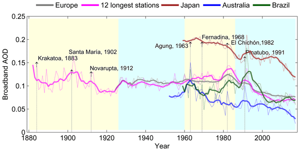
William Wandji Nyamsi, Ville Leinonen, Antti Lipponen, Else van den Besselaar, Santtu Mikkonen, Arturo Sanchez-Lorenzo, Martin Wild, Doris Folini, Tero Mielonen, Harri Kokkola, Antti Kukkurainen, Neus Sabater, Rei Kudo, Ben Liley, Raghav Srinivasan, Bruce W. Forgan, Alexandru Dumitrescu, Grzegorz Urban, Michał K. Kowalewski, Márcia Akemi Yamasoe, Nilton Évora do Rosário, Dimitra Founda, Stelios Kazadzis, Veronica Manara, Derbetini A. Vondou, Christian Gueymard, Anders V. Lindfors, Atsumu Ohmura, and Antti Arola
Atmos. Chem. Phys., 26, 10767–10788, https://doi.org/10.5194/acp-26-10767-2026, https://doi.org/10.5194/acp-26-10767-2026, 2026
Short summary
Short summary
Worldwide reconstructed historical aerosol load reveals that during the period of:
- 1900–1959: the atmosphere became cleaner in most European cities;
- 1960–1985: anthropogenic aerosols were responsible for the dimming phenomenon in Europe. AOD increased over Southeast Brazil and decreased noticeably over Japan while a small negative trend was found over Oceania;
- 1986–2015: generally, the atmosphere has become much cleaner everywhere after the reversal trend around 1980s mainly observed in Europe.
Andrea Porcheddu, Ville Kolehmainen, Timo Lähivaara, Robert Levy, Yingxi Rona Shi, Hai Zhang, and Antti Lipponen
EGUsphere, https://doi.org/10.5194/egusphere-2026-1987, https://doi.org/10.5194/egusphere-2026-1987, 2026
Short summary
Short summary
We developed a new way to improve satellite measurements of atmospheric aerosols, which affect air quality and climate. By combining data from two geostationary satellites and using advanced machine learning methods that capture changes over time, we achieved more accurate and detailed results. This approach reduces errors in current satellite-based aerosol data and can better support monitoring and decision making related to air pollution and climate impacts.
Nick Schutgens, Elisabeth J. Andrews, Antti Arola, Yusuf Bhatti, Guanliang Fu, Otto Hasekamp, Pekka Kolmonen, Antti Lipponen, Tero Mielonen, Leighton Reygare, and Andrew M. Sayer
EGUsphere, https://doi.org/10.5194/egusphere-2026-2656, https://doi.org/10.5194/egusphere-2026-2656, 2026
Short summary
Short summary
Aerosol are fine particles in the air that affect public health and the climate. We develop a new method to study aerosol through patterns (called autocorrelations) in their time-series. We show that autocorrelations are linked to aerosol deposition processes and contain information on the important but uncertain aerosol lifetime. Autocorrelations can be observed from satellites and we provide the first ever global climatology of aerosol autocorrelations.
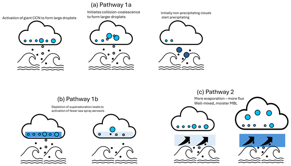
Vishnu Nair, Edward Gryspeerdt, Antti Arola, Antti Lipponen, and Timo Virtanen
Atmos. Chem. Phys., 26, 4049–4066, https://doi.org/10.5194/acp-26-4049-2026, https://doi.org/10.5194/acp-26-4049-2026, 2026
Short summary
Short summary
Surface winds affect clouds by generating sea salt aerosols and evaporating water from the ocean and transporting them to the cloud base. Previous studies analysed these processes using satellite snapshots; here we use observations of evolving clouds which capture feedbacks due to time-dependent adjustments of clouds to aerosol changes. We show that even though sea salt changes droplet sizes, evaporation from the ocean surface has a stronger impact on clouds, thus hiding the real aerosol effect.
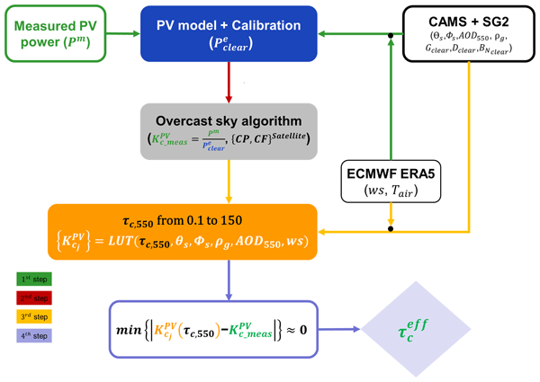
William Wandji Nyamsi, Anders V. Lindfors, Angela Meyer, Antti Lipponen, and Antti Arola
Atmos. Meas. Tech., 19, 899–922, https://doi.org/10.5194/amt-19-899-2026, https://doi.org/10.5194/amt-19-899-2026, 2026
Short summary
Short summary
This paper proposes a new, fast and accurate method for estimating the cloud optical depth (τc) from photovoltaic (PV) power measurements under overcast sky conditions. The method performs very well with the European Centre for Medium-Range Weather Forecasts (ECMWF) products as inputs describing the state of the atmosphere. The method exhibits a better performance than published state-of-the-art methods when compared to ground and satellite-based τc retrievals serving as reference.

Antti Kukkurainen, Antti Mikkonen, Antti Arola, Antti Lipponen, Ville Kolehmainen, and Neus Sabater
Geosci. Model Dev., 18, 7529–7544, https://doi.org/10.5194/gmd-18-7529-2025, https://doi.org/10.5194/gmd-18-7529-2025, 2025
Short summary
Short summary
HAPI2LIBIS is a new software tool that enhances the capabilities of the radiative transfer model libRadtran. It simplifies high-wavelength-resolution simulations by using up-to-date molecular data from the HITRAN (High-Resolution Transmission Molecular Absorption) database and streamlining computations. This tool helps researchers analyze how gases interact with radiation in the Earth's atmosphere and at the surface, improving atmospheric studies and satellite observations and making detailed modeling more accurate and accessible.
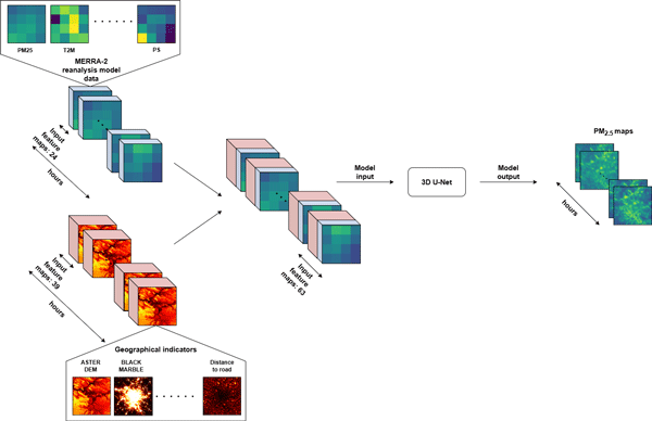
Andrea Porcheddu, Ville Kolehmainen, Timo Lähivaara, and Antti Lipponen
Atmos. Meas. Tech., 18, 4771–4789, https://doi.org/10.5194/amt-18-4771-2025, https://doi.org/10.5194/amt-18-4771-2025, 2025
Short summary
Short summary
This study proposes a novel machine learning method to estimate pollution levels (PM2.5) on urban areas at fine scale. Our model generates hourly PM2.5 maps with high spatial resolution, by combining satellite data, ground measurements, geophysical model data, and different geographical indicators. The model properly accounts for spatial and temporal variability of the urban pollution levels, and can be highly beneficial for air quality monitoring and health protection.
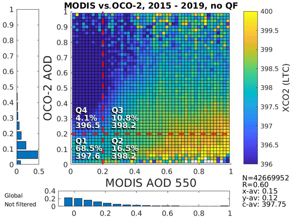
Timo H. Virtanen, Anu-Maija Sundström, Elli Suhonen, Antti Lipponen, Antti Arola, Christopher O'Dell, Robert R. Nelson, and Hannakaisa Lindqvist
Atmos. Meas. Tech., 18, 929–952, https://doi.org/10.5194/amt-18-929-2025, https://doi.org/10.5194/amt-18-929-2025, 2025
Short summary
Short summary
We find that small particles suspended in the air (aerosols) affect the satellite observations of carbon dioxide (CO2) made by the Orbiting Carbon Observatory-2 satellite instrument. Satellite estimates of CO2 appear to be too high for clean areas and too low for polluted areas. Our results show that CO2 and aerosols are often co-emitted, and this is partly masked out in the current retrievals. Correctly accounting for the aerosol effect is important for CO2 emission estimates by satellites.
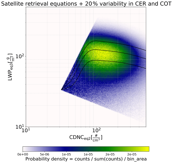
Harri Kokkola, Juha Tonttila, Silvia M. Calderón, Sami Romakkaniemi, Antti Lipponen, Aapo Peräkorpi, Tero Mielonen, Edward Gryspeerdt, Timo Henrik Virtanen, Pekka Kolmonen, and Antti Arola
Atmos. Chem. Phys., 25, 1533–1543, https://doi.org/10.5194/acp-25-1533-2025, https://doi.org/10.5194/acp-25-1533-2025, 2025
Short summary
Short summary
Understanding how atmospheric aerosols affect clouds is a scientific challenge. One question is how aerosols affects the amount of cloud water. We used a cloud-scale model to study these effects on marine clouds. The study showed that variations in cloud properties and instrument noise can cause bias in satellite-derived cloud water content. However, our results suggest that for similar weather conditions with well-defined aerosol concentrations, satellite data can reliably track these effects.
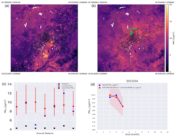
Andrea Porcheddu, Ville Kolehmainen, Timo Lähivaara, and Antti Lipponen
Atmos. Meas. Tech., 17, 5747–5764, https://doi.org/10.5194/amt-17-5747-2024, https://doi.org/10.5194/amt-17-5747-2024, 2024
Short summary
Short summary
This study focuses on improving the accuracy of satellite-based PM2.5 retrieval, crucial for monitoring air quality and its impact on health. It employs machine learning to correct the AOD-to-PM2.5 conversion ratio using various data sources. The approach produces high-resolution PM2.5 estimates with improved accuracy. The method is flexible and can incorporate additional training data from different sources, making it a valuable tool for air quality monitoring and epidemiological studies.
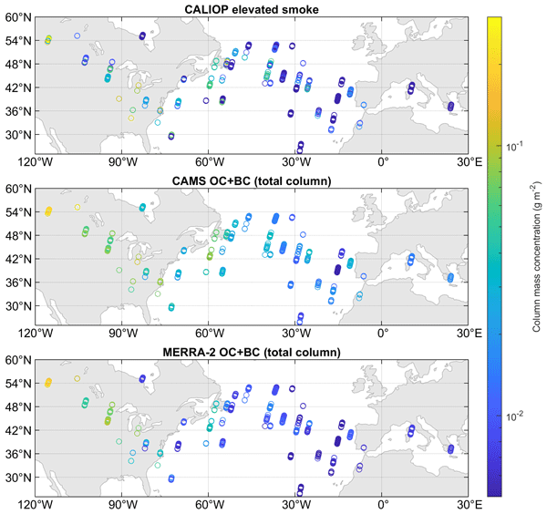
Xiaoxia Shang, Antti Lipponen, Maria Filioglou, Anu-Maija Sundström, Mark Parrington, Virginie Buchard, Anton S. Darmenov, Ellsworth J. Welton, Eleni Marinou, Vassilis Amiridis, Michael Sicard, Alejandro Rodríguez-Gómez, Mika Komppula, and Tero Mielonen
Atmos. Chem. Phys., 24, 1329–1344, https://doi.org/10.5194/acp-24-1329-2024, https://doi.org/10.5194/acp-24-1329-2024, 2024
Short summary
Short summary
In June 2019, smoke particles from a Canadian wildfire event were transported to Europe. The long-range-transported smoke plumes were monitored with a spaceborne lidar and reanalysis models. Based on the aerosol mass concentrations estimated from the observations, the reanalysis models had difficulties in reproducing the amount and location of the smoke aerosols during the transport event. Consequently, more spaceborne lidar missions are needed for reliable monitoring of aerosol plumes.
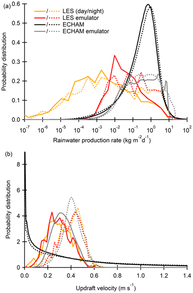
Kalle Nordling, Jukka-Pekka Keskinen, Sami Romakkaniemi, Harri Kokkola, Petri Räisänen, Antti Lipponen, Antti-Ilari Partanen, Jaakko Ahola, Juha Tonttila, Muzaffer Ege Alper, Hannele Korhonen, and Tomi Raatikainen
Atmos. Chem. Phys., 24, 869–890, https://doi.org/10.5194/acp-24-869-2024, https://doi.org/10.5194/acp-24-869-2024, 2024
Short summary
Short summary
Our results show that the global model is stable and it provides meaningful results. This way we can include a physics-based presentation of sub-grid physics (physics which happens on a 100 m scale) in the global model, whose resolution is on a 100 km scale.
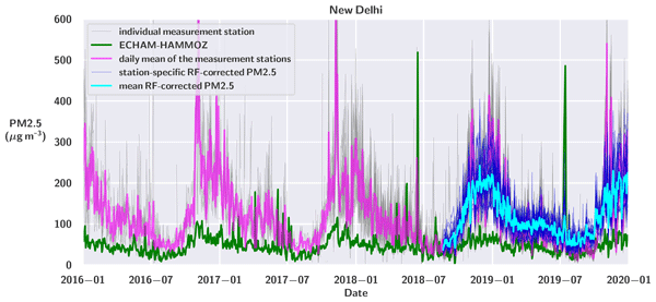
Tuuli Miinalainen, Harri Kokkola, Antti Lipponen, Antti-Pekka Hyvärinen, Vijay Kumar Soni, Kari E. J. Lehtinen, and Thomas Kühn
Atmos. Chem. Phys., 23, 3471–3491, https://doi.org/10.5194/acp-23-3471-2023, https://doi.org/10.5194/acp-23-3471-2023, 2023
Short summary
Short summary
We simulated the effects of aerosol emission mitigation on both global and regional radiative forcing and city-level air quality with a global-scale climate model. We used a machine learning downscaling approach to bias-correct the PM2.5 values obtained from the global model for the Indian megacity New Delhi. Our results indicate that aerosol mitigation could result in both improved air quality and less radiative heating for India.
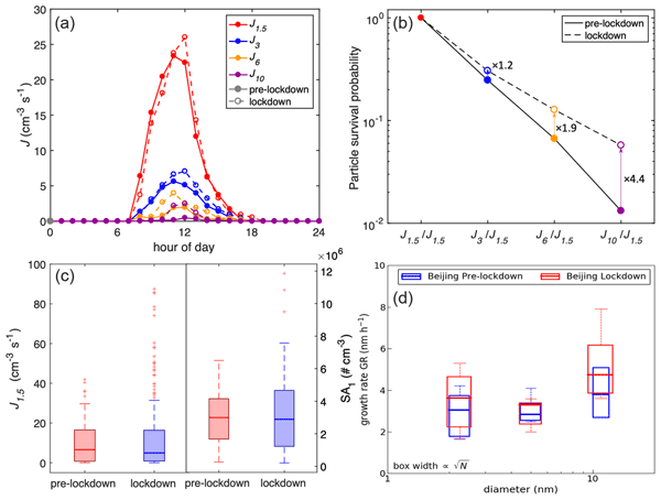
Chao Yan, Yicheng Shen, Dominik Stolzenburg, Lubna Dada, Ximeng Qi, Simo Hakala, Anu-Maija Sundström, Yishuo Guo, Antti Lipponen, Tom V. Kokkonen, Jenni Kontkanen, Runlong Cai, Jing Cai, Tommy Chan, Liangduo Chen, Biwu Chu, Chenjuan Deng, Wei Du, Xiaolong Fan, Xu-Cheng He, Juha Kangasluoma, Joni Kujansuu, Mona Kurppa, Chang Li, Yiran Li, Zhuohui Lin, Yiliang Liu, Yuliang Liu, Yiqun Lu, Wei Nie, Jouni Pulliainen, Xiaohui Qiao, Yonghong Wang, Yifan Wen, Ye Wu, Gan Yang, Lei Yao, Rujing Yin, Gen Zhang, Shaojun Zhang, Feixue Zheng, Ying Zhou, Antti Arola, Johanna Tamminen, Pauli Paasonen, Yele Sun, Lin Wang, Neil M. Donahue, Yongchun Liu, Federico Bianchi, Kaspar R. Daellenbach, Douglas R. Worsnop, Veli-Matti Kerminen, Tuukka Petäjä, Aijun Ding, Jingkun Jiang, and Markku Kulmala
Atmos. Chem. Phys., 22, 12207–12220, https://doi.org/10.5194/acp-22-12207-2022, https://doi.org/10.5194/acp-22-12207-2022, 2022
Short summary
Short summary
Atmospheric new particle formation (NPF) is a dominant source of atmospheric ultrafine particles. In urban environments, traffic emissions are a major source of primary pollutants, but their contribution to NPF remains under debate. During the COVID-19 lockdown, traffic emissions were significantly reduced, providing a unique chance to examine their relevance to NPF. Based on our comprehensive measurements, we demonstrate that traffic emissions alone are not able to explain the NPF in Beijing.
Jaakko Ahola, Tomi Raatikainen, Muzaffer Ege Alper, Jukka-Pekka Keskinen, Harri Kokkola, Antti Kukkurainen, Antti Lipponen, Jia Liu, Kalle Nordling, Antti-Ilari Partanen, Sami Romakkaniemi, Petri Räisänen, Juha Tonttila, and Hannele Korhonen
Atmos. Chem. Phys., 22, 4523–4537, https://doi.org/10.5194/acp-22-4523-2022, https://doi.org/10.5194/acp-22-4523-2022, 2022
Short summary
Short summary
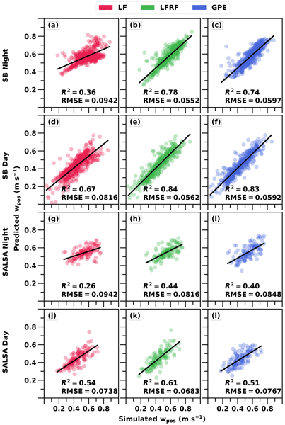
Clouds are important for the climate, and cloud droplets have a significant role in cloud properties. Cloud droplets form when air rises and cools and water vapour condenses on small particles that can be natural or of anthropogenic origin. Currently, the updraft velocity, meaning how fast the air rises, is poorly represented in global climate models. In our study, we show three methods that will improve the depiction of updraft velocity and which properties are vital to updrafts.
Antti Lipponen, Jaakko Reinvall, Arttu Väisänen, Henri Taskinen, Timo Lähivaara, Larisa Sogacheva, Pekka Kolmonen, Kari Lehtinen, Antti Arola, and Ville Kolehmainen
Atmos. Meas. Tech., 15, 895–914, https://doi.org/10.5194/amt-15-895-2022, https://doi.org/10.5194/amt-15-895-2022, 2022
Short summary
Short summary
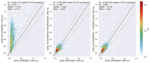
We have developed a machine-learning-based model that can be used to correct the Sentinel-3 satellite-based aerosol parameter data of the Synergy data product. The strength of the model is that the original satellite data processing does not have to be carried out again but the correction can be carried out with the data already available. We show that the correction significantly improves the accuracy of the satellite aerosol parameters.
Maria Christina Gatou, Antti Lipponen, Ari Leskinen, Petri Tiitta, Maria Filioglou, Xiaoxia Shang, Sanna Pätsi, Annika Saarto, Marjut Roponen, Elina Giannakaki, and Mika Komppula
Atmos. Meas. Tech., 19, 7387–7401, https://doi.org/10.5194/amt-19-7387-2026, https://doi.org/10.5194/amt-19-7387-2026, 2026
Short summary
Short summary
We investigate the pollen distribution at different heights using measurements from ground level up to 272 meters in eastern Finland. By combining optical pollen sensors with traditional monitoring methods and atmospheric model predictions, we examined how pollen concentrations vary with height. The results show that pollen concentrations decrease with altitude and that optical sensors combined with machine learning can identify dominant pollen types for continuous pollen monitoring.
Neus Sabater, Pekka Kolmonen, Marika Honkanen, Antti Kukkurainen, Andreas Burkart, Tommaso Julitta, Shari Van Wittenberghe, Ella Kivimäki, Hannakaisa Lindqvist, and Antti Arola
Int. Arch. Photogramm. Remote Sens. Spatial Inf. Sci., XLVIII-M-12-2026, 69–75, https://doi.org/10.5194/isprs-archives-XLVIII-M-12-2026-69-2026, https://doi.org/10.5194/isprs-archives-XLVIII-M-12-2026-69-2026, 2026
Kanika Taneja, Silvia M. Calderón, Harri Kokkola, Juha Tonttila, Sami Romakkaniemi, Seethala Chellappan, Antti Arola, Antti Lipponen, Taina Yli-Juuti, Snehitha M. Kommula, Tuukka Petäjä, Markku Kulmala, and Tero Mielonen
EGUsphere, https://doi.org/10.5194/egusphere-2026-4750, https://doi.org/10.5194/egusphere-2026-4750, 2026
Short summary
Short summary
Vegetation can cool the climate by releasing gases that form aerosols, which scatter sunlight and brighten clouds. To quantify this feedback in Finland and the United States, we combine field measurements of aerosols and satellite observations of clouds. It is essential to select near-ideal clouds; otherwise, cloud-related cooling is underestimated. Cloud cooling matched aerosol cooling at the clean site in Finland and was nearly three times stronger at the rural site in the United States.
Thomas F. Eck, Jeffrey S. Reid, Alexander Sinyuk, Pawan Gupta, Antti Arola, Ilya Slutsker, Brent N. Holben, Philippe Goloub, Oleg Dubovik, Joel S. Schafer, Mikhail G. Sorokin, Alexander Smirnov, Hongbin Yu, Dongchul Kim, Elena Lind, Jason Kraft, Elizabeth A. Reid, Aboubacry Diallo, Thierno Ndiaye, Africa Barreto, Sidi Baika, Lahouari Zeudmi-Sahraoui, Francisco Evora, Gael Dubois, Luc Blarel, Rachel T. Pinker, Isaac Abiodun Adimula, Jean Louis Rajot, Aliko Maman, Muguette Allegre, Cassandra Gaston, Peter Sealy, Edmund Blades, Rebecca Chewitt-Lucas, Ian Lau, David Barker, Adel Saad Alshihiween, Abdulrahman Alsaferan, Odbayar Mishigdorj, and Chogsom Jargalsaixan
EGUsphere, https://doi.org/10.5194/egusphere-2026-5531, https://doi.org/10.5194/egusphere-2026-5531, 2026
Short summary
Short summary
The optical properties of airborne soil particles from major desert regions measured by ground based remote sensing retrievals are presented. The relative spectral absorption of these particles from the remote sensing data agree very well with absorption of soil dust samples measured in a laboratory. A large fraction of the optical effects were attributed to relatively small submicron sized dust particles which would also be more easily inhalable and therefore may impact human health.
Yves-Marie Saint-Drenan, Lucien Wald, Cyril Voyant, Mireille Lefèvre, and Yehia Eissa
EGUsphere, https://doi.org/10.5194/egusphere-2026-3204, https://doi.org/10.5194/egusphere-2026-3204, 2026
Short summary
Short summary
To address the specific needs of cloud-free detection for the verification of clear-sky models, we introduce MuscaDet, a detector based on the correlation between irradiance measurements and locally fitted Lambert–Beer functions. It operates at multiple temporal scales and uses a dynamic tolerance to address common limitations of existing detectors. Evaluated using measurements from seven BSRN stations, MuscaDet reliably detects cloud-free periods, even at high solar zenithal angles.
William Wandji Nyamsi, Ville Leinonen, Antti Lipponen, Else van den Besselaar, Santtu Mikkonen, Arturo Sanchez-Lorenzo, Martin Wild, Doris Folini, Tero Mielonen, Harri Kokkola, Antti Kukkurainen, Neus Sabater, Rei Kudo, Ben Liley, Raghav Srinivasan, Bruce W. Forgan, Alexandru Dumitrescu, Grzegorz Urban, Michał K. Kowalewski, Márcia Akemi Yamasoe, Nilton Évora do Rosário, Dimitra Founda, Stelios Kazadzis, Veronica Manara, Derbetini A. Vondou, Christian Gueymard, Anders V. Lindfors, Atsumu Ohmura, and Antti Arola
Atmos. Chem. Phys., 26, 10767–10788, https://doi.org/10.5194/acp-26-10767-2026, https://doi.org/10.5194/acp-26-10767-2026, 2026
Short summary
Short summary
Worldwide reconstructed historical aerosol load reveals that during the period of:
- 1900–1959: the atmosphere became cleaner in most European cities;
- 1960–1985: anthropogenic aerosols were responsible for the dimming phenomenon in Europe. AOD increased over Southeast Brazil and decreased noticeably over Japan while a small negative trend was found over Oceania;
- 1986–2015: generally, the atmosphere has become much cleaner everywhere after the reversal trend around 1980s mainly observed in Europe.
Alessia Boccalatte, Yves-Marie Saint-Drenan, Benoît Gschwind, and Gabriel Chesnoiu
EGUsphere, https://doi.org/10.5194/egusphere-2026-4441, https://doi.org/10.5194/egusphere-2026-4441, 2026
This preprint is open for discussion and under review for Atmospheric Measurement Techniques (AMT).
Short summary
Short summary
Satellites that frequently observe large regions cannot directly see how clouds are arranged vertically. We tested whether a machine-learning method can reconstruct this three-dimensional structure by combining geostationary images with radar measurements. The method captured the broad height and amount of cloud, but smoothed strong signals and often lost separate cloud layers. It is therefore useful for broad cloud organisation, but not for fine vertical details.
Andrea Porcheddu, Ville Kolehmainen, Timo Lähivaara, Robert Levy, Yingxi Rona Shi, Hai Zhang, and Antti Lipponen
EGUsphere, https://doi.org/10.5194/egusphere-2026-1987, https://doi.org/10.5194/egusphere-2026-1987, 2026
Short summary
Short summary
We developed a new way to improve satellite measurements of atmospheric aerosols, which affect air quality and climate. By combining data from two geostationary satellites and using advanced machine learning methods that capture changes over time, we achieved more accurate and detailed results. This approach reduces errors in current satellite-based aerosol data and can better support monitoring and decision making related to air pollution and climate impacts.
Nick Schutgens, Elisabeth J. Andrews, Antti Arola, Yusuf Bhatti, Guanliang Fu, Otto Hasekamp, Pekka Kolmonen, Antti Lipponen, Tero Mielonen, Leighton Reygare, and Andrew M. Sayer
EGUsphere, https://doi.org/10.5194/egusphere-2026-2656, https://doi.org/10.5194/egusphere-2026-2656, 2026
Short summary
Short summary
Aerosol are fine particles in the air that affect public health and the climate. We develop a new method to study aerosol through patterns (called autocorrelations) in their time-series. We show that autocorrelations are linked to aerosol deposition processes and contain information on the important but uncertain aerosol lifetime. Autocorrelations can be observed from satellites and we provide the first ever global climatology of aerosol autocorrelations.
Vishnu Nair, Edward Gryspeerdt, Antti Arola, Antti Lipponen, and Timo Virtanen
Atmos. Chem. Phys., 26, 4049–4066, https://doi.org/10.5194/acp-26-4049-2026, https://doi.org/10.5194/acp-26-4049-2026, 2026
Short summary
Short summary
Surface winds affect clouds by generating sea salt aerosols and evaporating water from the ocean and transporting them to the cloud base. Previous studies analysed these processes using satellite snapshots; here we use observations of evolving clouds which capture feedbacks due to time-dependent adjustments of clouds to aerosol changes. We show that even though sea salt changes droplet sizes, evaporation from the ocean surface has a stronger impact on clouds, thus hiding the real aerosol effect.
William Wandji Nyamsi, Anders V. Lindfors, Angela Meyer, Antti Lipponen, and Antti Arola
Atmos. Meas. Tech., 19, 899–922, https://doi.org/10.5194/amt-19-899-2026, https://doi.org/10.5194/amt-19-899-2026, 2026
Short summary
Short summary
This paper proposes a new, fast and accurate method for estimating the cloud optical depth (τc) from photovoltaic (PV) power measurements under overcast sky conditions. The method performs very well with the European Centre for Medium-Range Weather Forecasts (ECMWF) products as inputs describing the state of the atmosphere. The method exhibits a better performance than published state-of-the-art methods when compared to ground and satellite-based τc retrievals serving as reference.
Yun Chen, Dazhi Yang, Chunlin Huang, Hongrong Shi, Adam R. Jensen, Xiang'ao Xia, Yves-Marie Saint-Drenan, Christian A. Gueymard, Martin János Mayer, and Yanbo Shen
Atmos. Meas. Tech., 18, 7315–7336, https://doi.org/10.5194/amt-18-7315-2025, https://doi.org/10.5194/amt-18-7315-2025, 2025
Short summary
Short summary
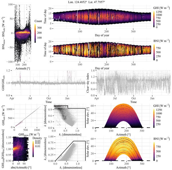
We tested two satellite-based irradiance datasets against both high- and low-accuracy ground-based measurements. The dataset is unique: it includes irradiance measurements from a new research-grade monitoring station in a rare climate, along with new satellite data from China's Fengyun-4B geostationary satellite. Findings suggest that using low-accuracy measurements as a reference for validation can be risky.
Antti Kukkurainen, Antti Mikkonen, Antti Arola, Antti Lipponen, Ville Kolehmainen, and Neus Sabater
Geosci. Model Dev., 18, 7529–7544, https://doi.org/10.5194/gmd-18-7529-2025, https://doi.org/10.5194/gmd-18-7529-2025, 2025
Short summary
Short summary
HAPI2LIBIS is a new software tool that enhances the capabilities of the radiative transfer model libRadtran. It simplifies high-wavelength-resolution simulations by using up-to-date molecular data from the HITRAN (High-Resolution Transmission Molecular Absorption) database and streamlining computations. This tool helps researchers analyze how gases interact with radiation in the Earth's atmosphere and at the surface, improving atmospheric studies and satellite observations and making detailed modeling more accurate and accessible.
Andrea Porcheddu, Ville Kolehmainen, Timo Lähivaara, and Antti Lipponen
Atmos. Meas. Tech., 18, 4771–4789, https://doi.org/10.5194/amt-18-4771-2025, https://doi.org/10.5194/amt-18-4771-2025, 2025
Short summary
Short summary
This study proposes a novel machine learning method to estimate pollution levels (PM2.5) on urban areas at fine scale. Our model generates hourly PM2.5 maps with high spatial resolution, by combining satellite data, ground measurements, geophysical model data, and different geographical indicators. The model properly accounts for spatial and temporal variability of the urban pollution levels, and can be highly beneficial for air quality monitoring and health protection.
Timo H. Virtanen, Anu-Maija Sundström, Elli Suhonen, Antti Lipponen, Antti Arola, Christopher O'Dell, Robert R. Nelson, and Hannakaisa Lindqvist
Atmos. Meas. Tech., 18, 929–952, https://doi.org/10.5194/amt-18-929-2025, https://doi.org/10.5194/amt-18-929-2025, 2025
Short summary
Short summary
We find that small particles suspended in the air (aerosols) affect the satellite observations of carbon dioxide (CO2) made by the Orbiting Carbon Observatory-2 satellite instrument. Satellite estimates of CO2 appear to be too high for clean areas and too low for polluted areas. Our results show that CO2 and aerosols are often co-emitted, and this is partly masked out in the current retrievals. Correctly accounting for the aerosol effect is important for CO2 emission estimates by satellites.
Harri Kokkola, Juha Tonttila, Silvia M. Calderón, Sami Romakkaniemi, Antti Lipponen, Aapo Peräkorpi, Tero Mielonen, Edward Gryspeerdt, Timo Henrik Virtanen, Pekka Kolmonen, and Antti Arola
Atmos. Chem. Phys., 25, 1533–1543, https://doi.org/10.5194/acp-25-1533-2025, https://doi.org/10.5194/acp-25-1533-2025, 2025
Short summary
Short summary
Understanding how atmospheric aerosols affect clouds is a scientific challenge. One question is how aerosols affects the amount of cloud water. We used a cloud-scale model to study these effects on marine clouds. The study showed that variations in cloud properties and instrument noise can cause bias in satellite-derived cloud water content. However, our results suggest that for similar weather conditions with well-defined aerosol concentrations, satellite data can reliably track these effects.
Job I. Wiltink, Hartwig Deneke, Yves-Marie Saint-Drenan, Chiel C. van Heerwaarden, and Jan Fokke Meirink
Atmos. Meas. Tech., 17, 6003–6024, https://doi.org/10.5194/amt-17-6003-2024, https://doi.org/10.5194/amt-17-6003-2024, 2024
Short summary
Short summary
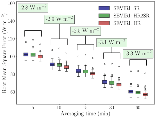
Meteosat Spinning Enhanced Visible and Infrared Imager (SEVIRI) global horizontal irradiance (GHI) retrievals are validated at standard and increased spatial resolution against a network of 99 pyranometers. GHI accuracy is strongly dependent on the cloud regime. Days with variable cloud conditions show significant accuracy improvements when retrieved at higher resolution. We highlight the benefits of dense network observations and a cloud-regime-resolved approach in validating GHI retrievals.
Andrea Porcheddu, Ville Kolehmainen, Timo Lähivaara, and Antti Lipponen
Atmos. Meas. Tech., 17, 5747–5764, https://doi.org/10.5194/amt-17-5747-2024, https://doi.org/10.5194/amt-17-5747-2024, 2024
Short summary
Short summary
This study focuses on improving the accuracy of satellite-based PM2.5 retrieval, crucial for monitoring air quality and its impact on health. It employs machine learning to correct the AOD-to-PM2.5 conversion ratio using various data sources. The approach produces high-resolution PM2.5 estimates with improved accuracy. The method is flexible and can incorporate additional training data from different sources, making it a valuable tool for air quality monitoring and epidemiological studies.
Xiaoxia Shang, Antti Lipponen, Maria Filioglou, Anu-Maija Sundström, Mark Parrington, Virginie Buchard, Anton S. Darmenov, Ellsworth J. Welton, Eleni Marinou, Vassilis Amiridis, Michael Sicard, Alejandro Rodríguez-Gómez, Mika Komppula, and Tero Mielonen
Atmos. Chem. Phys., 24, 1329–1344, https://doi.org/10.5194/acp-24-1329-2024, https://doi.org/10.5194/acp-24-1329-2024, 2024
Short summary
Short summary
In June 2019, smoke particles from a Canadian wildfire event were transported to Europe. The long-range-transported smoke plumes were monitored with a spaceborne lidar and reanalysis models. Based on the aerosol mass concentrations estimated from the observations, the reanalysis models had difficulties in reproducing the amount and location of the smoke aerosols during the transport event. Consequently, more spaceborne lidar missions are needed for reliable monitoring of aerosol plumes.
Kalle Nordling, Jukka-Pekka Keskinen, Sami Romakkaniemi, Harri Kokkola, Petri Räisänen, Antti Lipponen, Antti-Ilari Partanen, Jaakko Ahola, Juha Tonttila, Muzaffer Ege Alper, Hannele Korhonen, and Tomi Raatikainen
Atmos. Chem. Phys., 24, 869–890, https://doi.org/10.5194/acp-24-869-2024, https://doi.org/10.5194/acp-24-869-2024, 2024
Short summary
Short summary
Our results show that the global model is stable and it provides meaningful results. This way we can include a physics-based presentation of sub-grid physics (physics which happens on a 100 m scale) in the global model, whose resolution is on a 100 km scale.
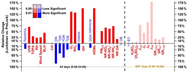
Markku Kulmala, Anna Lintunen, Hanna Lappalainen, Annele Virtanen, Chao Yan, Ekaterina Ezhova, Tuomo Nieminen, Ilona Riipinen, Risto Makkonen, Johanna Tamminen, Anu-Maija Sundström, Antti Arola, Armin Hansel, Kari Lehtinen, Timo Vesala, Tuukka Petäjä, Jaana Bäck, Tom Kokkonen, and Veli-Matti Kerminen
Atmos. Chem. Phys., 23, 14949–14971, https://doi.org/10.5194/acp-23-14949-2023, https://doi.org/10.5194/acp-23-14949-2023, 2023
Short summary
Short summary
To be able to meet global grand challenges, we need comprehensive open data with proper metadata. In this opinion paper, we describe the SMEAR (Station for Measuring Earth surface – Atmosphere Relations) concept and include several examples (cases), such as new particle formation and growth, feedback loops and the effect of COVID-19, and what has been learned from these investigations. The future needs and the potential of comprehensive observations of the environment are summarized.
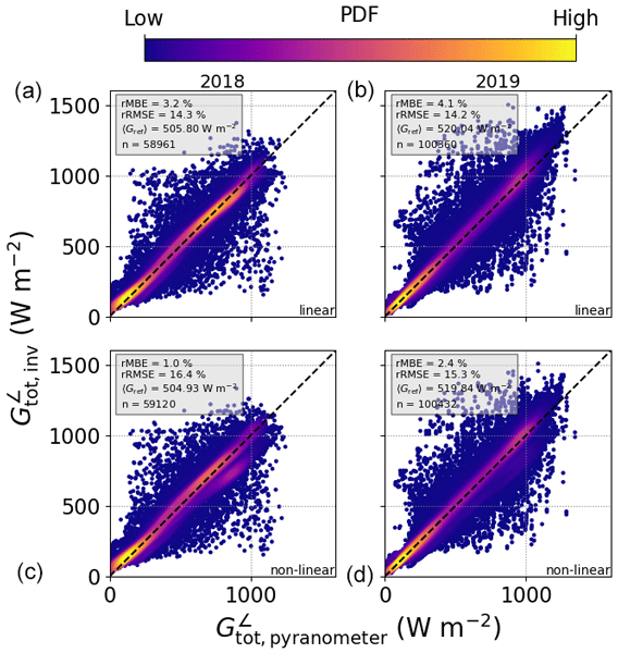
James Barry, Stefanie Meilinger, Klaus Pfeilsticker, Anna Herman-Czezuch, Nicola Kimiaie, Christopher Schirrmeister, Rone Yousif, Tina Buchmann, Johannes Grabenstein, Hartwig Deneke, Jonas Witthuhn, Claudia Emde, Felix Gödde, Bernhard Mayer, Leonhard Scheck, Marion Schroedter-Homscheidt, Philipp Hofbauer, and Matthias Struck
Atmos. Meas. Tech., 16, 4975–5007, https://doi.org/10.5194/amt-16-4975-2023, https://doi.org/10.5194/amt-16-4975-2023, 2023
Short summary
Short summary
Measured power data from solar photovoltaic (PV) systems contain information about the state of the atmosphere. In this work, power data from PV systems in the Allgäu region in Germany were used to determine the solar irradiance at each location, using state-of-the-art simulation and modelling. The results were validated using concurrent measurements of the incoming solar radiation in each case. If applied on a wider scale, this algorithm could help improve weather and climate models.
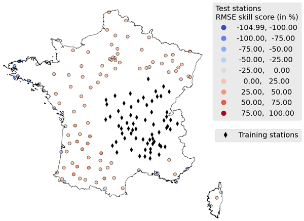
Hadrien Verbois, Yves-Marie Saint-Drenan, Vadim Becquet, Benoit Gschwind, and Philippe Blanc
Atmos. Meas. Tech., 16, 4165–4181, https://doi.org/10.5194/amt-16-4165-2023, https://doi.org/10.5194/amt-16-4165-2023, 2023
Short summary
Short summary
Solar surface irradiance (SSI) estimations inferred from satellite images are essential to gain a comprehensive understanding of the solar resource, which is crucial in many fields. This study examines the recent data-driven methods for inferring SSI from satellite images and explores their strengths and weaknesses. The results suggest that while these methods show great promise, they sometimes dramatically underperform and should probably be used in conjunction with physical approaches.
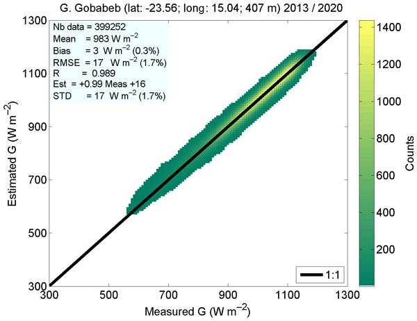
William Wandji Nyamsi, Yves-Marie Saint-Drenan, Antti Arola, and Lucien Wald
Atmos. Meas. Tech., 16, 2001–2036, https://doi.org/10.5194/amt-16-2001-2023, https://doi.org/10.5194/amt-16-2001-2023, 2023
Short summary
Short summary
The McClear service provides estimates of surface solar irradiances in cloud-free conditions. By comparing McClear estimates to 1 min measurements performed in Sub-Saharan Africa and the Maldives Archipelago in the Indian Ocean, McClear accurately estimates global irradiance and tends to overestimate direct irrradiance. This work establishes a general overview of the performance of the McClear service.
Tuuli Miinalainen, Harri Kokkola, Antti Lipponen, Antti-Pekka Hyvärinen, Vijay Kumar Soni, Kari E. J. Lehtinen, and Thomas Kühn
Atmos. Chem. Phys., 23, 3471–3491, https://doi.org/10.5194/acp-23-3471-2023, https://doi.org/10.5194/acp-23-3471-2023, 2023
Short summary
Short summary
We simulated the effects of aerosol emission mitigation on both global and regional radiative forcing and city-level air quality with a global-scale climate model. We used a machine learning downscaling approach to bias-correct the PM2.5 values obtained from the global model for the Indian megacity New Delhi. Our results indicate that aerosol mitigation could result in both improved air quality and less radiative heating for India.
Chao Yan, Yicheng Shen, Dominik Stolzenburg, Lubna Dada, Ximeng Qi, Simo Hakala, Anu-Maija Sundström, Yishuo Guo, Antti Lipponen, Tom V. Kokkonen, Jenni Kontkanen, Runlong Cai, Jing Cai, Tommy Chan, Liangduo Chen, Biwu Chu, Chenjuan Deng, Wei Du, Xiaolong Fan, Xu-Cheng He, Juha Kangasluoma, Joni Kujansuu, Mona Kurppa, Chang Li, Yiran Li, Zhuohui Lin, Yiliang Liu, Yuliang Liu, Yiqun Lu, Wei Nie, Jouni Pulliainen, Xiaohui Qiao, Yonghong Wang, Yifan Wen, Ye Wu, Gan Yang, Lei Yao, Rujing Yin, Gen Zhang, Shaojun Zhang, Feixue Zheng, Ying Zhou, Antti Arola, Johanna Tamminen, Pauli Paasonen, Yele Sun, Lin Wang, Neil M. Donahue, Yongchun Liu, Federico Bianchi, Kaspar R. Daellenbach, Douglas R. Worsnop, Veli-Matti Kerminen, Tuukka Petäjä, Aijun Ding, Jingkun Jiang, and Markku Kulmala
Atmos. Chem. Phys., 22, 12207–12220, https://doi.org/10.5194/acp-22-12207-2022, https://doi.org/10.5194/acp-22-12207-2022, 2022
Short summary
Short summary
Atmospheric new particle formation (NPF) is a dominant source of atmospheric ultrafine particles. In urban environments, traffic emissions are a major source of primary pollutants, but their contribution to NPF remains under debate. During the COVID-19 lockdown, traffic emissions were significantly reduced, providing a unique chance to examine their relevance to NPF. Based on our comprehensive measurements, we demonstrate that traffic emissions alone are not able to explain the NPF in Beijing.
Benoît Tournadre, Benoît Gschwind, Yves-Marie Saint-Drenan, Xuemei Chen, Rodrigo Amaro E Silva, and Philippe Blanc
Atmos. Meas. Tech., 15, 3683–3704, https://doi.org/10.5194/amt-15-3683-2022, https://doi.org/10.5194/amt-15-3683-2022, 2022
Short summary
Short summary
Solar radiation received by the Earth's surface is valuable information for various fields like the photovoltaic industry or climate research. Pictures taken from satellites can be used to estimate the solar radiation from cloud reflectivity. Two issues for a good estimation are different instrumentations and orbits. We modify a widely used method that is today only used on geostationary satellites, so it can be applied on instruments on different orbits and with different sensitivities.
Jaakko Ahola, Tomi Raatikainen, Muzaffer Ege Alper, Jukka-Pekka Keskinen, Harri Kokkola, Antti Kukkurainen, Antti Lipponen, Jia Liu, Kalle Nordling, Antti-Ilari Partanen, Sami Romakkaniemi, Petri Räisänen, Juha Tonttila, and Hannele Korhonen
Atmos. Chem. Phys., 22, 4523–4537, https://doi.org/10.5194/acp-22-4523-2022, https://doi.org/10.5194/acp-22-4523-2022, 2022
Short summary
Short summary
Clouds are important for the climate, and cloud droplets have a significant role in cloud properties. Cloud droplets form when air rises and cools and water vapour condenses on small particles that can be natural or of anthropogenic origin. Currently, the updraft velocity, meaning how fast the air rises, is poorly represented in global climate models. In our study, we show three methods that will improve the depiction of updraft velocity and which properties are vital to updrafts.
Antti Lipponen, Jaakko Reinvall, Arttu Väisänen, Henri Taskinen, Timo Lähivaara, Larisa Sogacheva, Pekka Kolmonen, Kari Lehtinen, Antti Arola, and Ville Kolehmainen
Atmos. Meas. Tech., 15, 895–914, https://doi.org/10.5194/amt-15-895-2022, https://doi.org/10.5194/amt-15-895-2022, 2022
Short summary
Short summary
We have developed a machine-learning-based model that can be used to correct the Sentinel-3 satellite-based aerosol parameter data of the Synergy data product. The strength of the model is that the original satellite data processing does not have to be carried out again but the correction can be carried out with the data already available. We show that the correction significantly improves the accuracy of the satellite aerosol parameters.
Cited articles
CAMS Radiation Service: Regular Validation Reports, Copernicus Atmosphere Monitoring Service, https://atmosphere.copernicus.eu/supplementary-services (last access: 13 May 2026), 2025. a
Chen, T. and Guestrin, C.: XGBoost: A scalable tree boosting system, in: Proceedings of the 22nd ACM SIGKDD international conference on knowledge discovery and data mining, Association for Computing Machinery, 785–794, https://doi.org/10.1145/2939672.2939785, 2016. a
Copernicus Atmosphere Monitoring Service (CAMS): CAMS solar radiation time‐series, Copernicus Atmosphere Monitoring Service (CAMS) Atmosphere Data Store [data set], https://doi.org/10.24381/5cab0912, 2020. a, b
Copernicus Atmosphere Monitoring Service (CAMS): Supplementary Services, https://atmosphere.copernicus.eu/supplementary-services (last access: 17 July 2026), 2026. a
Dong, J., Zeng, W., Wu, L., Huang, J., Gaiser, T., and Srivastava, A. K.: Enhancing short-term forecasting of daily precipitation using numerical weather prediction bias correcting with XGBoost in different regions of China, Eng. Appl. Artif. Intel., 117, 105579, https://doi.org/10.1016/j.engappai.2022.105579, 2023. a
Driemel, A., Augustine, J., Behrens, K., Colle, S., Cox, C., Cuevas-Agulló, E., Denn, F. M., Duprat, T., Fukuda, M., Grobe, H., Haeffelin, M., Hodges, G., Hyett, N., Ijima, O., Kallis, A., Knap, W., Kustov, V., Long, C. N., Longenecker, D., Lupi, A., Maturilli, M., Mimouni, M., Ntsangwane, L., Ogihara, H., Olano, X., Olefs, M., Omori, M., Passamani, L., Pereira, E. B., Schmithüsen, H., Schumacher, S., Sieger, R., Tamlyn, J., Vogt, R., Vuilleumier, L., Xia, X., Ohmura, A., and König-Langlo, G.: Baseline Surface Radiation Network (BSRN): structure and data description (1992–2017), Earth Syst. Sci. Data, 10, 1491–1501, https://doi.org/10.5194/essd-10-1491-2018, 2018. a
Friedman, J.: Greedy function approximation: A gradient boosting machine, Ann. Stat., 29, 1189–1232, https://doi.org/10.1214/aos/1013203451, 2001. a
Gneiting, T., Raftery, A. E., Westveld III, A. H., and Goldman, T.: Calibrated probabilistic forecasting using ensemble model output statistics and minimum CRPS estimation, Mon. Weather Rev., 133, 1098–1118, https://doi.org/10.1175/MWR2904.1, 2005. a
Gschwind, B., Wald, L., Blanc, P., Lefèvre, M., Schroedter-Homscheidt, M., and Arola, A.: Improving the McClear model estimating the downwelling solar radiation at ground level in cloud-free conditions – McClear-v3, Meteorol. Z., 28, https://doi.org/10.1127/metz/2019/0946, 2019. a
IN-SITU: In-Situ data viewer, https://viewer.webservice-energy.org/in-situ/ (last access: 13 May 2026), 2025. a
Kenny, D. and Fiedler, S.: Which gridded irradiance data is best for modelling photovoltaic power production in Germany?, Sol. Energy, 232, 444–458, https://doi.org/10.1016/j.solener.2021.12.044, 2022. a
Klüser, L., Killius, N., and Gesell, G.: APOLLO_NG – a probabilistic interpretation of the APOLLO legacy for AVHRR heritage channels, Atmos. Meas. Tech., 8, 4155–4170, https://doi.org/10.5194/amt-8-4155-2015, 2015. a
Lefèvre, M., Oumbe, A., Blanc, P., Espinar, B., Gschwind, B., Qu, Z., Wald, L., Schroedter-Homscheidt, M., Hoyer-Klick, C., Arola, A., Benedetti, A., Kaiser, J. W., and Morcrette, J.-J.: McClear: a new model estimating downwelling solar radiation at ground level in clear-sky conditions, Atmos. Meas. Tech., 6, 2403–2418, https://doi.org/10.5194/amt-6-2403-2013, 2013. a, b
Lezaca Galeano, J. E., Saint-Drenan, Y.-M., and Schroedter-Homscheidt, M.: A Probabilistic Approach to Quantify the Uncertainty of the 1 Min Irradiance Estimates from the Copernicus Atmosphere Monitoring Service (CAMS) Radiation Service, Solar RRL, 9, e202500568, https://doi.org/10.1002/solr.202500568, 2025. a
Lipponen, A.: Machine-learning-based approach for solar radiation model prediction error identification, attribution and correction script, Version v1.0.0, Zenodo [computer software], https://doi.org/10.5281/zenodo.24194868, 2026. a
Lipponen, A., Kolehmainen, V., Romakkaniemi, S., and Kokkola, H.: Correction of approximation errors with Random Forests applied to modelling of cloud droplet formation, Geosci. Model Dev., 6, 2087–2098, https://doi.org/10.5194/gmd-6-2087-2013, 2013. a
Lipponen, A., Huttunen, J. M., Romakkaniemi, S., Kokkola, H., and Kolehmainen, V.: Correction of model reduction errors in simulations, SIAM J. Sci. Comput., 40, B305–B327, 2018. a
Lipponen, A., Kolehmainen, V., Kolmonen, P., Kukkurainen, A., Mielonen, T., Sabater, N., Sogacheva, L., Virtanen, T. H., and Arola, A.: Model-enforced post-process correction of satellite aerosol retrievals, Atmos. Meas. Tech., 14, 2981–2992, https://doi.org/10.5194/amt-14-2981-2021, 2021. a
Long, C. and Dutton, E.: BSRN Global Network recommended QC tests, V2.0, Tech. rep., Baseline Surface Radiation Network, https://epic.awi.de/id/eprint/30083/1/BSRN_recommended_QC_tests_V2.pdf (last access: 13 May 2026), 2022. a
Lundberg, S. M., Erion, G., Chen, H., DeGrave, A., Prutkin, J. M., Nair, B., Katz, R., Himmelfarb, J., Bansal, N., and Lee, S.-I.: From local explanations to global understanding with explainable AI for trees, Nature Machine Intelligence, 2, 56–67, https://doi.org/10.1038/s42256-019-0138-9, 2020. a
Ma, J., Yu, Z., Qu, Y., Xu, J., and Cao, Y.: Application of the XGBoost machine learning method in PM2.5 prediction: A case study of Shanghai, Aerosol Air Qual. Res., 20, 128–138, https://doi.org/10.4209/aaqr.2019.08.0408, 2020. a
Mabasa, B., Lysko, M. D., and Moloi, S. J.: Validating hourly satellite based and reanalysis based global horizontal irradiance datasets over South Africa, Geomatics, 1, 429–449, https://doi.org/10.3390/geomatics1040025, 2021. a
Mardaljevic, J., Brembilla, E., and Eames, M.: Daylight solar radiation AMY data derived from satellite remote sensing: Validation against ground measurements and comparison with TMYs, Build. Serv. Eng. Res. T., 46, 653–691, https://doi.org/10.1177/01436244251335160, 2025. a
Muschinski, T., Mayr, G. J., Zeileis, A., and Simon, T.: Robust weather-adaptive post-processing using model output statistics random forests, Nonlin. Processes Geophys., 30, 503–514, https://doi.org/10.5194/npg-30-503-2023, 2023. a
Myers, D. R.: Solar radiation modeling and measurements for renewable energy applications: data and model quality, Energy, 30, 1517–1531, https://doi.org/10.1016/j.energy.2004.04.034, 2005. a
Natekin, A. and Knoll, A.: Gradient boosting machines, a tutorial, Front. Neurorobotics, 7, 21, https://doi.org/10.3389/fnbot.2013.00021, 2013. a
Peuch, V.-H., Engelen, R., Rixen, M., Dee, D., Flemming, J., Suttie, M., Ades, M., Agustí-Panareda, A., Ananasso, C., Andersson, E., Armstrong, D., Barré, J., Bousserez, N., Dominguez, J. J., Garrigues, S., Inness, A., Jones, L., Kipling, Z., Letertre-Danczak, J., Parrington, M., Razinger, M., Ribas, R., Vermoote, S., Yang, X., Simmons, A., Garcés de Marcilla, J., and Thépaut, J.-N.: The Copernicus Atmosphere Monitoring Service: From research to operations, B. Am. Meteorol. Soc., 103, E2650–E2668, https://doi.org/10.1175/BAMS-D-21-0314.1, 2022. a, b
Qu, Z., Oumbe, A., Blanc, P., Espinar, B., Gesell, G., Gschwind, B., Klüser, L., Lefèvre, M., Saboret, L., Schroedter-Homscheidt, M., and Wald, L.: Fast radiative transfer parameterisation for assessing the surface solar irradiance: The Heliosat-4 method, Meteorol. Z., 26, 33–57, https://doi.org/10.1127/metz/2016/0781, 2017. a, b
Riise, H. N., Nygard, M. M., Aarseth, B. L., Dobler, A., and Berge, E.: Benchmark of estimated solar irradiance data at high latitude locations, Sol. Energy, 282, 112975, https://doi.org/10.1016/j.solener.2024.112975, 2024. a
SAURAN: Southern African Universities Radiometric Network, https://sauran.ac.za/ (last access: 13 May 2026), 2025. a
Schroedter-Homscheidt, M., Azam, F., Betcke, J., Hanrieder, N., Lefevre, M., Saboret, L., and Saint-Drenan, Y.-M.: Surface solar irradiation retrieval from MSG/SEVIRI based on APOLLO Next Generation and HELIOSAT-4 methods, Meteorol. Z., 31, 455–476, https://doi.org/10.1127/metz/2022/1132, 2022. a, b, c
Schüler, D., Wilbert, S., Geuder, N., Affolter, R., Wolfertstetter, F., Prahl, C., Röger, M., Schroedter-Homscheidt, M., Abdellatif, G., Guizani, A. A., Balghouthi, M., Khalil, A., Mezrhab, A., Al-Salaymeh, A., Yassaa, N., Chellali, F., Draou, D., Blanc, P., Dubranna, J., and Sabry, O. M. K.: The enerMENA meteorological network – Solar radiation measurements in the MENA region, AIP Conf. Proc., 1734, 150008, https://doi.org/10.1063/1.4949240, 2016. a
Shapley, L.: A value for n-person games, in: Contributions to the Theory of Games AM-28, Princeton University Press, II, 307–318, https://doi.org/10.1515/9781400881970-018, 1953. a
Urraca, R., Trentmann, J., Pfeifroth, U., and Gobron, N.: Can satellite products monitor solar brightening in Europe?, Remote Sens. Environ., 315, 114472, https://doi.org/10.1016/j.rse.2024.114472, 2024. a
Wild, M., Folini, D., Schär, C., Loeb, N., Dutton, E. G., and König-Langlo, G.: The global energy balance from a surface perspective, Clim. Dynam., 40, 3107–3134, https://doi.org/10.1007/s00382-012-1569-8, 2013. a
Zhen, J., Mao, D., Shen, Z., Zhao, D., Xu, Y., Wang, J., Jia, M., Wang, Z., and Ren, C.: Performance of xgboost ensemble learning algorithm for mangrove species classification with multisource spaceborne remote sensing data, Journal of Remote Sensing, 4, 0146, https://doi.org/10.34133/remotesensing.0146, 2024. a
Short summary
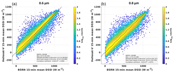
We studied what causes errors in Copernicus Atmosphere Monitoring Service solar radiation data using explainable machine learning methods and ground-based observations. The analysis showed that cloud properties are the main source of errors, while aerosols and surface reflectance have smaller effects. The results improve understanding of the strengths and weaknesses of current models and can support future model development, forecasting and solar energy applications.
We studied what causes errors in Copernicus Atmosphere Monitoring Service solar radiation data...


Altmetrics
Final-revised paper
Preprint