
Articles | Volume 19, issue 14
https://doi.org/10.5194/amt-19-4637-2026
© Author(s) 2026. This work is distributed under
the Creative Commons Attribution 4.0 License.
the Creative Commons Attribution 4.0 License.
https://doi.org/10.5194/amt-19-4637-2026
© Author(s) 2026. This work is distributed under
the Creative Commons Attribution 4.0 License.
the Creative Commons Attribution 4.0 License.
Research article
| 
21 Jul 2026
Research article |
| 21 Jul 2026
| 21 Jul 2026
Automatic methane plume masking based on wavelet transform image processing: application to MethaneAIR and MethaneSAT data

Environmental Defense Fund, Washington, DC, USA
Harvard John A. Paulson School of Engineering and Applied Sciences, Harvard University, Cambridge, MA, USA
Maryann Sargent
Harvard John A. Paulson School of Engineering and Applied Sciences, Harvard University, Cambridge, MA, USA
Ethan Manninen
Harvard John A. Paulson School of Engineering and Applied Sciences, Harvard University, Cambridge, MA, USA
Jack D. Warren
Environmental Defense Fund, Washington, DC, USA
Apisada Chulakadabba
Professorship of Environmental Sensing and Modeling, Technical University of Munich, Munich, Germany
Marcus Russi
Environmental Defense Fund, Washington, DC, USA
Sasha Ayvazov
Environmental Defense Fund, Washington, DC, USA
Joshua Benmergui
Environmental Defense Fund, Washington, DC, USA
Harvard John A. Paulson School of Engineering and Applied Sciences, Harvard University, Cambridge, MA, USA
Marvin Knapp
Environmental Defense Fund, Washington, DC, USA
Harvard John A. Paulson School of Engineering and Applied Sciences, Harvard University, Cambridge, MA, USA
Ethan Kyzivat
Harvard John A. Paulson School of Engineering and Applied Sciences, Harvard University, Cambridge, MA, USA
Christopher C. Miller
Environmental Defense Fund, Washington, DC, USA
Harvard John A. Paulson School of Engineering and Applied Sciences, Harvard University, Cambridge, MA, USA
Harvard–Smithsonian Center for Astrophysics, Cambridge, MA, USA
Sébastien Roche
Environmental Defense Fund, Washington, DC, USA
Harvard John A. Paulson School of Engineering and Applied Sciences, Harvard University, Cambridge, MA, USA
Harvard–Smithsonian Center for Astrophysics, Cambridge, MA, USA
Bingkun Luo
Harvard–Smithsonian Center for Astrophysics, Cambridge, MA, USA
David J. Miller
Harvard John A. Paulson School of Engineering and Applied Sciences, Harvard University, Cambridge, MA, USA
Maya Nasr
Environmental Defense Fund, Washington, DC, USA
Harvard John A. Paulson School of Engineering and Applied Sciences, Harvard University, Cambridge, MA, USA
Manuel Perez-Carrasco
Harvard–Smithsonian Center for Astrophysics, Cambridge, MA, USA
Department of Civil, Structural and Environmental Engineering, University at Buffalo, Buffalo, NY, USA
James P. Williams
Environmental Defense Fund, Washington, DC, USA
Katlyn MacKay
Environmental Defense Fund, Washington, DC, USA
Mark Omara
Environmental Defense Fund, Washington, DC, USA
Professorship of Environmental Sensing and Modeling, Technical University of Munich, Munich, Germany
Luis Guanter
Environmental Defense Fund, Washington, DC, USA
University of Valencia, Valencia, Spain
Ritesh Gautam
Environmental Defense Fund, Washington, DC, USA
Jonathan Franklin
Harvard John A. Paulson School of Engineering and Applied Sciences, Harvard University, Cambridge, MA, USA
Xiong Liu
Harvard–Smithsonian Center for Astrophysics, Cambridge, MA, USA
Steven C. Wofsy
CORRESPONDING AUTHOR
Harvard John A. Paulson School of Engineering and Applied Sciences, Harvard University, Cambridge, MA, USA
Related authors
Jacob B. H. Bushey, Michael Bertolacci, Joshua Benmergui, Julian Kostinek, Maryann Sargent, Marvin Knapp, Ethan Kyzivat, Sasha Ayvazov, Marcus Russi, Zhan Zhang, Apisada Chulakadabba, Jia Chen, Christopher Chan Miller, Sébastien Roche, Lucas A. Estrada, James D. East, Luna Yin, James P. Williams, Anthony Himmelberger, Ritesh Gautam, Mark Omara, and Steven C. Wofsy
EGUsphere, https://doi.org/10.5194/egusphere-2026-4693, https://doi.org/10.5194/egusphere-2026-4693, 2026
This preprint is open for discussion and under review for Atmospheric Measurement Techniques (AMT).
Short summary
Short summary
MethaneSAT was a designed to measure the concentration of methane in the atmosphere over oil and gas producing regions. Our modeling framework uses observations from MethaneSAT to estimate emissions from the Permian Basin. We show that the model accurately captures spatial patterns in emissions and compares well to other models that rely on different atmospheric transport. This data set is valuable for emissions monitoring and mitigation at high spatial resolution and with high precision.
Penelope Smale, Alexander Geddes, Sara Mikaloff-Fletcher, Zhan Zhang, Apisada Chulakadabba, MaryAnn Sargent, Christopher C. Miller, Sébastien Roche, Joseph Rudek, Jonathan Franklin, Jack Warren, and Steven Wofsy
Atmos. Chem. Phys., 26, 10661–10677, https://doi.org/10.5194/acp-26-10661-2026, https://doi.org/10.5194/acp-26-10661-2026, 2026
Short summary
Short summary
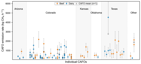
MethaneAIR was used to quantify methane emissions from concentrated animal feeding operations (CAFOs) using a targeted scene‑based approach with wavelet denoising. Emissions show substantial variability and are often elevated relative to inventory estimates under detectable conditions, reflecting variability, detection bias, and activity data uncertainty. Results highlight MethaneAIR capability and the potential of future satellite platforms.
James P. Williams, Joshua Benmergui, Marvin Knapp, Mark Omara, Anthony Himmelberger, Ethan Kyzivat, Kaiya Weatherby, Ben Lyke, Jack Warren, Katlyn MacKay, Sasha Ayvazov, Marcus Russi, Nicholas LoFaso, Tom Melendez, Christopher C. Miller, Sebastien Roche, Maryann Sargent, Jonathan Franklin, Maya Nasr, Zhan Zhang, David J. Miller, Bingkun Luo, Luis Guanter, Steven P. Hamburg, Steven C. Wofsy, and Ritesh Gautam
Atmos. Chem. Phys., 26, 5961–5981, https://doi.org/10.5194/acp-26-5961-2026, https://doi.org/10.5194/acp-26-5961-2026, 2026
Short summary
Short summary
Methane is a potent greenhouse gas, and satellite observations are critical for reducing emissions. Using 2024–2025 MethaneSAT data, we quantify methane emissions across six major oil and gas basins at high resolution, revealing substantial underestimation at basin, subbasin, and local levels. Our results underscore the need for new, spatially resolved measurements and the continued advancement of remote sensing capabilities to provide more detailed, actionable insights for methane mitigation.
Luis Guanter, Javier Roger, Jack Warren, Maryann Sargent, Zhan Zhang, Sébastien Roche, Christopher Chan Miller, Michael Steiner, Harvey Hadfield, Mark Omara, James Williams, Katlyn MacKay, Jonathan E. Franklin, Bingkun Luo, Steven C. Wofsy, Steven P. Hamburg, and Ritesh Gautam
Atmos. Chem. Phys., 26, 2941–2963, https://doi.org/10.5194/acp-26-2941-2026, https://doi.org/10.5194/acp-26-2941-2026, 2026
Short summary
Short summary
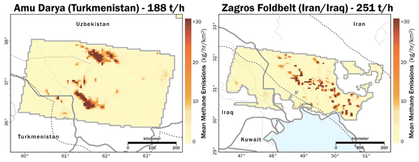
We evaluate the potential of the MethaneSAT satellite mission to detect and quantify methane plumes from high emitting point sources and use the existing MethaneSAT data archive to evaluate super-emissions from the most important oil and gas basins in the world.
Ethan Manninen, Apisada Chulakadabba, Maryann Sargent, Zhan Zhang, Harshil Kamdar, Jack Warren, Sébastien Roche, Christopher Chan Miller, Ethan Kyzivat, Joshua Benmergui, Jasna Pittman, Eleanor Walker, Jacob Bushey, Jenna Samra, Jacob Hawthorne, Bingkun Luo, Maya Nasr, Kang Sun, Jonathan Franklin, Xiong Liu, Jia Chen, and Steven Wofsy
EGUsphere, https://doi.org/10.5194/egusphere-2026-115, https://doi.org/10.5194/egusphere-2026-115, 2026
Short summary
Short summary
In this work, my coauthors and I interpret methane emissions observed by remote sensing systems as plumes, or point sources. We model the probability that a general imaging spectrometer will detect a plume, and apply this framework to multiple remote sensing systems. We show how two recent systems- MethanAIR and MethaneSAT- provide enough sensitivity to facility scale point sources to effectively characterize most plume emissions in the Permian Basin.
Katlyn MacKay, Joshua Benmergui, James P. Williams, Mark Omara, Anthony Himmelberger, Maryann Sargent, Jack D. Warren, Christopher C. Miller, Sébastien Roche, Zhan Zhang, Jonathan Franklin, Luis Guanter, Steven Wofsy, and Ritesh Gautam
Atmos. Chem. Phys., 26, 1179–1192, https://doi.org/10.5194/acp-26-1179-2026, https://doi.org/10.5194/acp-26-1179-2026, 2026
Short summary
Short summary
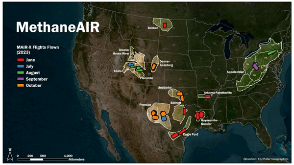
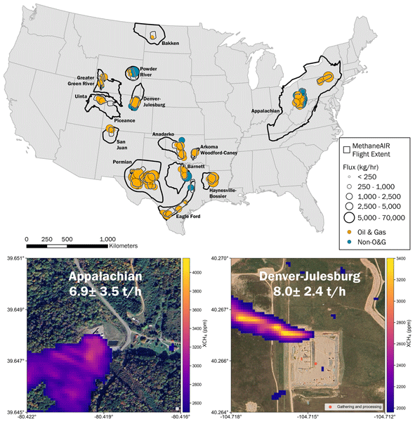
Reducing methane emissions from the oil/gas sector can mitigate near-term climate warming and the losses of a valuable energy resource. We analyze data collected using MethaneAIR to assess methane emissions in regions accounting for 70 % of United States onshore oil/gas production in 2023. We estimate total oil/gas methane emissions across all measured regions to be ~8 Tg/yr, equivalent to 1.6 % of produced gas, which is five times higher than reported by the US Environmental Protection Agency.
Jack D. Warren, Maryann Sargent, James P. Williams, Mark Omara, Christopher C. Miller, Sebastien Roche, Katlyn MacKay, Ethan Manninen, Apisada Chulakadabba, Anthony Himmelberger, Joshua Benmergui, Zhan Zhang, Luis Guanter, Steve Wofsy, and Ritesh Gautam
Atmos. Chem. Phys., 25, 10661–10675, https://doi.org/10.5194/acp-25-10661-2025, https://doi.org/10.5194/acp-25-10661-2025, 2025
Short summary
Short summary
Mitigating anthropogenic methane emissions requires a detailed understanding of emitting facilities. We use observations of methane point sources from the MethaneAIR instrument from 2021–2023 that covered ~80 % of US onshore oil and gas production regions. We attribute these observations to facility types to explore how emissions vary by industrial sectors. Oil and gas facilities make up most point source emissions nationally, but in certain basins other sectors can make up the majority.
Jacob B. H. Bushey, Michael Bertolacci, Joshua Benmergui, Julian Kostinek, Maryann Sargent, Marvin Knapp, Ethan Kyzivat, Sasha Ayvazov, Marcus Russi, Zhan Zhang, Apisada Chulakadabba, Jia Chen, Christopher Chan Miller, Sébastien Roche, Lucas A. Estrada, James D. East, Luna Yin, James P. Williams, Anthony Himmelberger, Ritesh Gautam, Mark Omara, and Steven C. Wofsy
EGUsphere, https://doi.org/10.5194/egusphere-2026-4693, https://doi.org/10.5194/egusphere-2026-4693, 2026
This preprint is open for discussion and under review for Atmospheric Measurement Techniques (AMT).
Short summary
Short summary
MethaneSAT was a designed to measure the concentration of methane in the atmosphere over oil and gas producing regions. Our modeling framework uses observations from MethaneSAT to estimate emissions from the Permian Basin. We show that the model accurately captures spatial patterns in emissions and compares well to other models that rely on different atmospheric transport. This data set is valuable for emissions monitoring and mitigation at high spatial resolution and with high precision.
Clara M. Nussbaumer, Colette L. Heald, Teresa Campos, Eric A. Kort, Paul B. Krummel, Ray L. Langenfelds, Monica Madronich, Kathryn McKain, Gabrielle Pétron, Ann Stavert, and Steven C. Wofsy
EGUsphere, https://doi.org/10.5194/egusphere-2026-5476, https://doi.org/10.5194/egusphere-2026-5476, 2026
This preprint is open for discussion and under review for Atmospheric Chemistry and Physics (ACP).
Short summary
Short summary
Changes in emissions and climate increasingly impact the remote Southern Hemisphere and we know little about the consequences for the atmospheric composition. We investigate if rapid increases in the greenhouse gas methane since 2008 have led to increases in carbon monoxide. A global model confirms this hypothesis and shows that enhanced emissions from plants and rising temperatures also contribute to the trend. Observations are inconsistent and highlight the need for more accurate measurements.
Tobias Grasberger, Jia Chen, Benjamin Zanger, Alessandro Lupoli, Moritz Oliveira Makowski, Josef Stauber, and Felix Krahmer
EGUsphere, https://doi.org/10.5194/egusphere-2026-3161, https://doi.org/10.5194/egusphere-2026-3161, 2026
This preprint is open for discussion and under review for Geoscientific Model Development (GMD).
Short summary
Short summary
As climate change makes reliable city-scale greenhouse gas monitoring more urgent, we developed a new mathematical method to better trace back emissions in cities. We combine approaches that detect point sources with methods that estimate widespread emissions for inferring urban emissions from air measurements. The result is a more accurate emission field reconstruction than traditional methods, adapted to the heterogeneous urban greenhouse gas emissions and supporting targeted climate action.
Ayesha Riaz, Kang Sun, Brian D. Baker, Brian Buma, Karen E. Cady-Pereira, Christopher Chan Miller, William C. Eddy III, Betsy M. Farris, Thomas U. Kampe, Eric A. Kort, Nathan P. Leisso, Robert Spurr, Emily R. Stuchiner, and Wendy H. Yang
Atmos. Meas. Tech., 19, 5169–5191, https://doi.org/10.5194/amt-19-5169-2026, https://doi.org/10.5194/amt-19-5169-2026, 2026
Short summary
Short summary
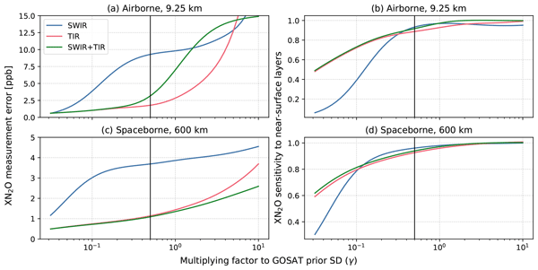
N2O is a powerful greenhouse gas mainly released from agricultural soils, but its emissions are difficult to track as they vary strongly in space and time. We tested whether combining two kind of infrared measurements in one instrument could improve ability of airborne and satellite instruments to observe these emissions. We found that this combined approach improves sensitivity to near-surface emissions with low measurement error and could guide the design of future N2O dedicated missions.
Penelope Smale, Alexander Geddes, Sara Mikaloff-Fletcher, Zhan Zhang, Apisada Chulakadabba, MaryAnn Sargent, Christopher C. Miller, Sébastien Roche, Joseph Rudek, Jonathan Franklin, Jack Warren, and Steven Wofsy
Atmos. Chem. Phys., 26, 10661–10677, https://doi.org/10.5194/acp-26-10661-2026, https://doi.org/10.5194/acp-26-10661-2026, 2026
Short summary
Short summary
MethaneAIR was used to quantify methane emissions from concentrated animal feeding operations (CAFOs) using a targeted scene‑based approach with wavelet denoising. Emissions show substantial variability and are often elevated relative to inventory estimates under detectable conditions, reflecting variability, detection bias, and activity data uncertainty. Results highlight MethaneAIR capability and the potential of future satellite platforms.
Leonie Olivia Scheidweiler, Ida Jandl, Lukas Häffner, Marvin Knapp, Lennart Resch, Benedikt Löw, Christian Mielke, Sanam N. Vardag, and André Butz
EGUsphere, https://doi.org/10.5194/egusphere-2026-3730, https://doi.org/10.5194/egusphere-2026-3730, 2026
This preprint is open for discussion and under review for Atmospheric Measurement Techniques (AMT).
Short summary
Short summary
Methane is the second-most important greenhouse gas produced by humans. Satellites are able to measure methane emissions for individual facilities. We compare three approaches for converting satellite measurements into methane concentrations, which is one step needed for estimating emission rates. The three approaches have similar results for sufficiently large sources, but diverge for smaller sources. We showcase a hybrid method that combines the advantages of two popular approaches.
Christopher Chan Miller, Sébastien Roche, Jonas Wilzweski, Xiong Liu, Kelly V. Chance, Bingkun Luo, Kang Sun, Jonathan E. Franklin, Joshua S. Benmergui, Maya Nasr, David J. Miller, Sean Crowell, Nathan Leisso, Eleanor Walker, Ritesh Gautam, Nicholas LoFaso, Sasha Ayvazov, David Wells, Carlos Cervantes, Christopher Hairfield, and Steven Wofsy
EGUsphere, https://doi.org/10.5194/egusphere-2026-3365, https://doi.org/10.5194/egusphere-2026-3365, 2026
Short summary
Short summary
Reducing oil and gas methane emissions is among the fastest ways to slow near-term climate change, and satellites offer a transparent means of verifying progress. MethaneSAT fills a gap between existing instruments, which either measure methane accurately but at coarse scales, or detect large leaks at fine resolution without the accuracy to account for all sources. We present the first measurements and show they meet the accuracy requirements for regional emissions mapping at the 2–4 km2 scale.
David J. Miller, Kang Sun, Jonathan E. Franklin, Nathan Leisso, Sébastien Roche, Bingkun Luo, Christopher Chan Miller, Sasha Ayvazov, Sean Crowell, Nick LoFaso, Tom Kampe, Peter Spuhler, Betsy Farris, Eleanor Walker, Tom Melendez, Ritesh Gautam, Xiong Liu, and Steven C. Wofsy
EGUsphere, https://doi.org/10.5194/egusphere-2026-2675, https://doi.org/10.5194/egusphere-2026-2675, 2026
This preprint is open for discussion and under review for Atmospheric Measurement Techniques (AMT).
Short summary
Short summary
With a focus on mitigating climate change, the MethaneSAT satellite mission aims to catalyze methane emission reductions. MethaneSAT has provided high-resolution emissions products across global oil and gas basins. We present novel calibration methods of MethaneSAT's instrumentation that demonstrate stable on-orbit performance compared with ground-based calibration. Our results are important for similar satellite missions focused on monitoring climate-relevant emissions.
Yanxia Li, Hengheng Zhang, Xuefeng Shi, Yaowei Li, Sophie Abou-Rizk, Jessica B. Smith, Zhaojin An, Adrian Wenzel, Junwei Song, Thomas Leisner, Frank Keutsch, Jia Chen, and Harald Saathoff
EGUsphere, https://doi.org/10.5194/egusphere-2026-2195, https://doi.org/10.5194/egusphere-2026-2195, 2026
Short summary
Short summary
Urban ultrafine particles (<100 nm) sources and growth mechanisms remain poorly constrained. Measurements in a Munich street canyon reveal that UFP number concentrations peak at night due to traffic and cooking emissions trapped under a shallow boundary layer. Particle growth is instead driven by condensation of organic vapours with strong seasonal shifts: biogenic and barbeque charcoal biomass-burning compounds dominate in summer, while combustion-related organics control winter growth.
Jacoline van Es, Juan Bettinelli, Jia Chen, Carina van der Veen, Stephan Henne, and Thomas Röckmann
EGUsphere, https://doi.org/10.5194/egusphere-2026-1813, https://doi.org/10.5194/egusphere-2026-1813, 2026
Short summary
Short summary
The increase in atmospheric methane needs to be reversed to mitigate ongoing global warming. To design effective mitigation strategies at the local/regional level, we need to know what the main sources in different regions. We show that in Hamburg, Germany, biogenic sources are the main contributor to local emissions, with additional contributions from waste and fossil CH4 sources. An unexpected source is the Elbe River, with spiking emissions at low tide when the river banks are exposed.
James P. Williams, Joshua Benmergui, Marvin Knapp, Mark Omara, Anthony Himmelberger, Ethan Kyzivat, Kaiya Weatherby, Ben Lyke, Jack Warren, Katlyn MacKay, Sasha Ayvazov, Marcus Russi, Nicholas LoFaso, Tom Melendez, Christopher C. Miller, Sebastien Roche, Maryann Sargent, Jonathan Franklin, Maya Nasr, Zhan Zhang, David J. Miller, Bingkun Luo, Luis Guanter, Steven P. Hamburg, Steven C. Wofsy, and Ritesh Gautam
Atmos. Chem. Phys., 26, 5961–5981, https://doi.org/10.5194/acp-26-5961-2026, https://doi.org/10.5194/acp-26-5961-2026, 2026
Short summary
Short summary
Methane is a potent greenhouse gas, and satellite observations are critical for reducing emissions. Using 2024–2025 MethaneSAT data, we quantify methane emissions across six major oil and gas basins at high resolution, revealing substantial underestimation at basin, subbasin, and local levels. Our results underscore the need for new, spatially resolved measurements and the continued advancement of remote sensing capabilities to provide more detailed, actionable insights for methane mitigation.
Yanxia Li, Hengheng Zhang, Xuefeng Shi, Yaowei Li, Sophie Abou-Rizk, Jessica B. Smith, Zhaojin An, Adrian Wenzel, Junwei Song, Thomas Leisner, Frank Keutsch, Jia Chen, and Harald Saathoff
Atmos. Chem. Phys., 26, 5813–5837, https://doi.org/10.5194/acp-26-5813-2026, https://doi.org/10.5194/acp-26-5813-2026, 2026
Short summary
Short summary
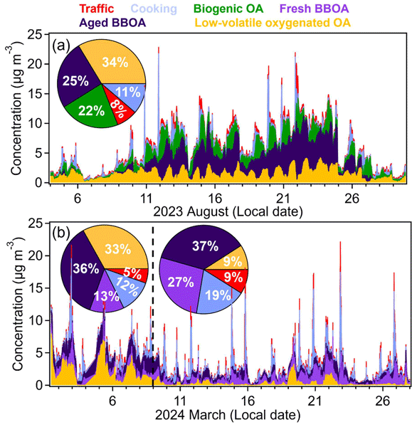
We analyzed Munich air samples across seasons to identify pollution sources. Traffic contributes less to particles than expected, while biomass burning dominates year-round. Summer barbecuing and winter heating release significant pollution. Monoterpene emissions from plants produce particles at night. Effective air quality improvement requires year-round strategies targeting biomass burning, not just vehicles. Understanding each city's pollution patterns is essential for public health.
Ling Chen, Zhaonan Cai, Kang Sun, Yi Liu, Dongxu Yang, Mingming Li, and Lingyun Zhu
Earth Syst. Sci. Data, 18, 2749–2767, https://doi.org/10.5194/essd-18-2749-2026, https://doi.org/10.5194/essd-18-2749-2026, 2026
Short summary
Short summary
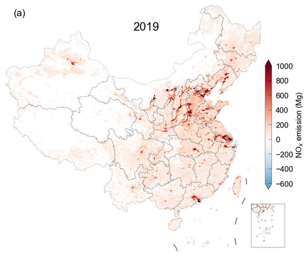
An appropriate representation of the NOx/NO2 ratio and NOx lifetime is essential for satellite-based NOx emissions estimation. We introduce a lightweight approach that applies variable NOx/NO2 ratios and piecewise fitting based on the directional derivative approach (DDA) to estimate regional and point-source NOx emissions. Our method directly captures nonlinear NOx chemistry and serves as an efficient alternative to both bottom-up inventories and computationally demanding top-down models.
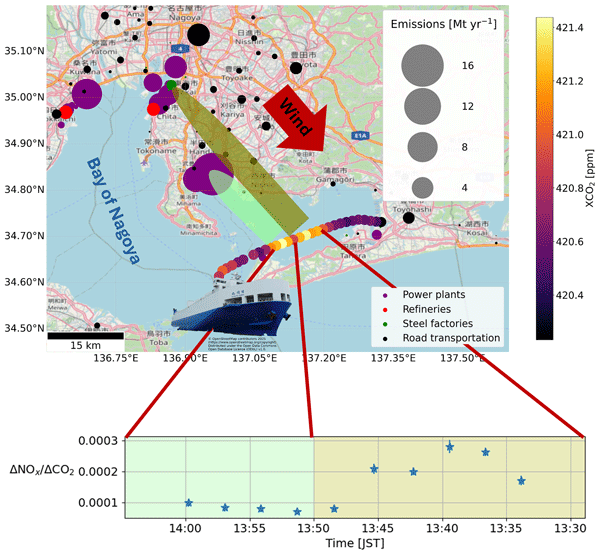
Vincent Enders, Astrid Müller, Matthias Max Frey, Frank Hase, Ralph Kleinschek, Marvin Knapp, Benedikt Löw, Isamu Morino, Shin-Ichiro Nakaoka, Hideki Nara, Hiroshi Tanimoto, Sanam N. Vardag, Karolin Voss, and André Butz
Atmos. Meas. Tech., 19, 2633–2655, https://doi.org/10.5194/amt-19-2633-2026, https://doi.org/10.5194/amt-19-2633-2026, 2026
Short summary
Short summary
We have deployed two spectrometers on a ship traveling along the coast of Japan. By that, we were able to repeatedly measure the greenhouse gas and air pollutant emissions of power plants, large industrial facilities, and cities. Using the ratios between the different gases, we are able to identify sources based on their unique signature. In addition, we are able to show that spectrometers can be operated on a ship, while still fulfilling the high standards of land-based observation networks.
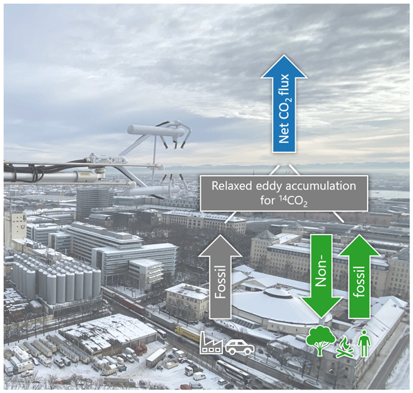
Ann-Kristin Kunz, Samuel Hammer, Patrick Aigner, Laura Bignotti, Lars Borchardt, Jia Chen, Julian Della Coletta, Lukas Emmenegger, Markus Eritt, Xochilt Gutiérrez, Josh Hashemi, Rainer Hilland, Christopher Holst, Armin Jordan, Natascha Kljun, Richard Kneißl, Changxing Lan, Virgile Legendre, Ingeborg Levin, Benjamin Loubet, Matthias Mauder, Betty Molinier, Susanne Preunkert, Michel Ramonet, Stavros Stagakis, and Andreas Christen
Atmos. Chem. Phys., 26, 4967–5003, https://doi.org/10.5194/acp-26-4967-2026, https://doi.org/10.5194/acp-26-4967-2026, 2026
Short summary
Short summary
We present radiocarbon (14C)-based fossil fuel CO2 fluxes from relaxed eddy accumulation measurements on tall towers in the cities of Zurich, Paris, and Munich. By separating net CO2 fluxes into fossil and non-fossil components, these data reveal significant and variable contributions from human, plant, and soil respiration, as well as point-source emissions. These unique insights into CO2 flux composition offer crucial information for observation-based validation of urban emission estimates.
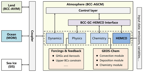
Ruize Sun, Xiao Lu, Haipeng Lin, Tongwen Wu, Xingpei Ye, Lu Shen, Xuan Wang, Haolin Wang, Jingyu Li, Ni Lu, Jiayin Su, Jie Zhang, Fang Zhang, Xiaoge Xin, Xiong Liu, Xiao Yang, and Lin Zhang
Geosci. Model Dev., 19, 2111–2136, https://doi.org/10.5194/gmd-19-2111-2026, https://doi.org/10.5194/gmd-19-2111-2026, 2026
Short summary
Short summary
We present the development of a global chemistry-climate coupled model BCC-GEOS-Chem v2.0, with improved representation of comprehensive troposphere-stratosphere chemistry and new capability to account for radiative-cloud feedbacks from short-lived climate forcers. The development of the BCC-GEOS-Chem v2.0 provides a useful framework for investigating climate–chemistry interactions and for future projections of global atmospheric chemistry
Luis Guanter, Javier Roger, Jack Warren, Maryann Sargent, Zhan Zhang, Sébastien Roche, Christopher Chan Miller, Michael Steiner, Harvey Hadfield, Mark Omara, James Williams, Katlyn MacKay, Jonathan E. Franklin, Bingkun Luo, Steven C. Wofsy, Steven P. Hamburg, and Ritesh Gautam
Atmos. Chem. Phys., 26, 2941–2963, https://doi.org/10.5194/acp-26-2941-2026, https://doi.org/10.5194/acp-26-2941-2026, 2026
Short summary
Short summary
We evaluate the potential of the MethaneSAT satellite mission to detect and quantify methane plumes from high emitting point sources and use the existing MethaneSAT data archive to evaluate super-emissions from the most important oil and gas basins in the world.
Ethan Manninen, Apisada Chulakadabba, Maryann Sargent, Zhan Zhang, Harshil Kamdar, Jack Warren, Sébastien Roche, Christopher Chan Miller, Ethan Kyzivat, Joshua Benmergui, Jasna Pittman, Eleanor Walker, Jacob Bushey, Jenna Samra, Jacob Hawthorne, Bingkun Luo, Maya Nasr, Kang Sun, Jonathan Franklin, Xiong Liu, Jia Chen, and Steven Wofsy
EGUsphere, https://doi.org/10.5194/egusphere-2026-115, https://doi.org/10.5194/egusphere-2026-115, 2026
Short summary
Short summary
In this work, my coauthors and I interpret methane emissions observed by remote sensing systems as plumes, or point sources. We model the probability that a general imaging spectrometer will detect a plume, and apply this framework to multiple remote sensing systems. We show how two recent systems- MethanAIR and MethaneSAT- provide enough sensitivity to facility scale point sources to effectively characterize most plume emissions in the Permian Basin.
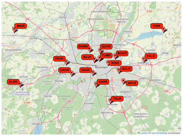
Patrick Aigner, Jia Chen, Felix Böhm, Mali Chariot, Lukas Emmenegger, Lars Frölich, Stuart Grange, Daniel Kühbacher, Klaus Kürzinger, Olivier Laurent, Moritz Makowski, Pascal Rubli, Adrian Schmitt, and Adrian Wenzel
Atmos. Meas. Tech., 19, 745–773, https://doi.org/10.5194/amt-19-745-2026, https://doi.org/10.5194/amt-19-745-2026, 2026
Short summary
Short summary
Dense urban CO2 monitoring is challenging due to cost and operational constraints. We developed a mid-cost sensor network for Munich, deployed on 17 rooftops. Temperature-stabilized enclosures and automated 2-point calibration ensured reliable performance, assessed by side-by-side comparison with a Picarro reference. In 1.5 years, the network collected 90 million measurements and resolved urban-rural gradients and seasonal diurnal patterns, capturing spatial CO2 variability at city scale.
Friedrich Klappenbach, Jia Chen, Moritz Makowski, Andreas Luther, Ronald C. Cohen, Jonathan E. Franklin, Steven Wofsy, and Taylor Jones
EGUsphere, https://doi.org/10.5194/egusphere-2026-204, https://doi.org/10.5194/egusphere-2026-204, 2026
Short summary
Short summary
This work presents a method to infer the upwind distance of emission sources from observed peak enhancements in atmospheric trace gas measurements. Using meteorological model output, the expected dilution of emissions from candidate source locations is quantified and compared with the observed concentration signals. The method enables the identification of plausible source locations and provides quantitative estimates of their emission strengths.
Katlyn MacKay, Joshua Benmergui, James P. Williams, Mark Omara, Anthony Himmelberger, Maryann Sargent, Jack D. Warren, Christopher C. Miller, Sébastien Roche, Zhan Zhang, Jonathan Franklin, Luis Guanter, Steven Wofsy, and Ritesh Gautam
Atmos. Chem. Phys., 26, 1179–1192, https://doi.org/10.5194/acp-26-1179-2026, https://doi.org/10.5194/acp-26-1179-2026, 2026
Short summary
Short summary
Reducing methane emissions from the oil/gas sector can mitigate near-term climate warming and the losses of a valuable energy resource. We analyze data collected using MethaneAIR to assess methane emissions in regions accounting for 70 % of United States onshore oil/gas production in 2023. We estimate total oil/gas methane emissions across all measured regions to be ~8 Tg/yr, equivalent to 1.6 % of produced gas, which is five times higher than reported by the US Environmental Protection Agency.
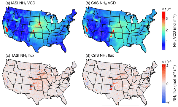
Zitong Li, Kang Sun, Kaiyu Guan, Sheng Wang, Bin Peng, Lieven Clarisse, Martin Van Damme, Pierre-François Coheur, Karen Cady-Pereira, Mark W. Shephard, Mark Zondlo, and Daniel Moore
Atmos. Chem. Phys., 26, 703–721, https://doi.org/10.5194/acp-26-703-2026, https://doi.org/10.5194/acp-26-703-2026, 2026
Short summary
Short summary
We estimate ammonia fluxes over the contiguous U.S. from 2008 to 2022 using a directional derivative approach applied to satellite observations from the Infrared Atmospheric Sounding Interferometer (IASI) and Cross-track Infrared Sounder (CrIS). The resulting flux estimates reveal pronounced seasonal and spatial patterns driven by agricultural activities and indicate substantial local deposition to surrounding vegetation, underscoring the need for improved monitoring and management strategies.
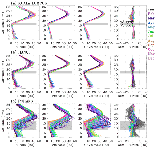
Juseon Bak, Arno Keppens, Daesung Choi, Sungjae Hong, Jae-Hwan Kim, Cheol-Hee Kim, Hyo-Jung Lee, Wonbae Jeon, Jhoon Kim, Ja-Ho Koo, Joowan Kim, Kanghyun Baek, Kai Yang, Xiong Liu, Gonzalo González Abad, Klaus-Peter Heue, Jean-Christopher Lambert, Yeonjin Jung, Hyunkee Hong, and Won-Jin Lee
Atmos. Meas. Tech., 19, 119–134, https://doi.org/10.5194/amt-19-119-2026, https://doi.org/10.5194/amt-19-119-2026, 2026
Short summary
Short summary
This study presents the first complete description of the operational version 3 ozone profile retrieval algorithm for the Geostationary Environment Monitoring Spectrometer (GEMS) and its performance characteristics. Improvements in radiometric and wavelength calibration reduce spectral fitting uncertainties and enhance agreement with ozonesonde profiles and Pandora total ozone measurements.
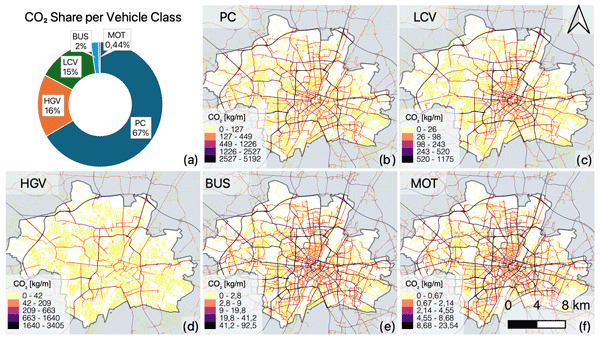
Daniel Kühbacher, Jia Chen, Patrick Aigner, Mario Ilic, Ingrid Super, and Hugo Denier van der Gon
Geosci. Model Dev., 18, 9967–9990, https://doi.org/10.5194/gmd-18-9967-2025, https://doi.org/10.5194/gmd-18-9967-2025, 2025
Short summary
Short summary
We present DRIVE v1.0, a data-driven framework to estimate road transport emissions, their temporal profiles, and the associated uncertainties. The method was applied to the city of Munich, where we present bottom-up emission estimates for the years 2019 to 2022. The estimates are compared against official municipal reports as well as national and European downscaled inventories.
Jack H. Bruno, Daniel J. Jacob, Xiaolin Wang, Melissa P. Sulprizio, Lucas A. Estrada, Daniel J. Varon, Steven C. Wofsy, Mark Omara, and Ritesh Gautam
EGUsphere, https://doi.org/10.5194/egusphere-2025-4626, https://doi.org/10.5194/egusphere-2025-4626, 2025
Preprint archived
Short summary
Short summary
We use data from both aircraft (MethaneAIR) and satellite (TROPOMI) based measurements of methane in the atmosphere to better understand methane emissions from fossil fuel extraction. Data from these instruments are combined with a computer model of the atmosphere to improve estimates of methane emissions. We find that combining data from multiple sources provides more information than either source on its own. The tools and data we use are freely available.
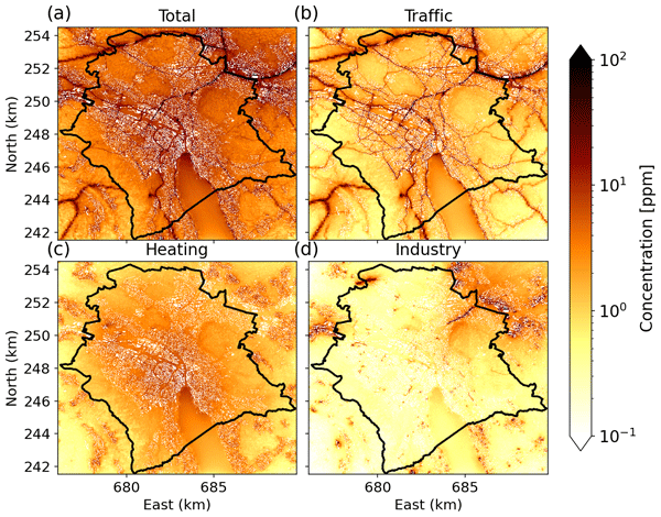
Dominik Brunner, Ivo Suter, Leonie Bernet, Lionel Constantin, Stuart K. Grange, Pascal Rubli, Junwei Li, Jia Chen, Alessandro Bigi, and Lukas Emmenegger
Atmos. Chem. Phys., 25, 14387–14410, https://doi.org/10.5194/acp-25-14387-2025, https://doi.org/10.5194/acp-25-14387-2025, 2025
Short summary
Short summary
To support the city of Zurich in tracking its path to net-zero greenhouse gas emissions planned to be reached by 2040, a CO2 emission monitoring system was established. The system combines a dense network of CO2 sensors with a high-resolution atmospheric transport model GRAMM/GRAL. This study presents the setup of the model together with its numerous inputs and evaluates its performance in comparison with observations from the CO2 sensor network.
Jack D. Warren, Maryann Sargent, James P. Williams, Mark Omara, Christopher C. Miller, Sebastien Roche, Katlyn MacKay, Ethan Manninen, Apisada Chulakadabba, Anthony Himmelberger, Joshua Benmergui, Zhan Zhang, Luis Guanter, Steve Wofsy, and Ritesh Gautam
Atmos. Chem. Phys., 25, 10661–10675, https://doi.org/10.5194/acp-25-10661-2025, https://doi.org/10.5194/acp-25-10661-2025, 2025
Short summary
Short summary
Mitigating anthropogenic methane emissions requires a detailed understanding of emitting facilities. We use observations of methane point sources from the MethaneAIR instrument from 2021–2023 that covered ~80 % of US onshore oil and gas production regions. We attribute these observations to facility types to explore how emissions vary by industrial sectors. Oil and gas facilities make up most point source emissions nationally, but in certain basins other sectors can make up the majority.
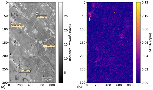
Luis Guanter, Jack Warren, Mark Omara, Apisada Chulakadabba, Javier Roger, Maryann Sargent, Jonathan E. Franklin, Steven C. Wofsy, and Ritesh Gautam
Atmos. Meas. Tech., 18, 3857–3872, https://doi.org/10.5194/amt-18-3857-2025, https://doi.org/10.5194/amt-18-3857-2025, 2025
Short summary
Short summary
This study presents a data processing scheme for the detection and quantification of methane emissions using the MethaneAIR airborne spectrometer. We show that the proposed methods enable the detection of smaller plumes (compared with those detectable using other existing methods) and improve the potential of MethaneAIR to survey methane point sources across large regions.
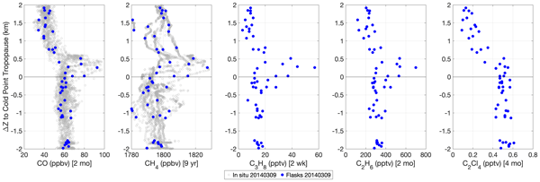
Jasna V. Pittman, Bruce C. Daube, Steven C. Wofsy, Elliot L. Atlas, Maria A. Navarro, Eric J. Hintsa, Fred L. Moore, Geoff S. Dutton, James W. Elkins, Troy D. Thornberry, Andrew W. Rollins, Eric J. Jensen, Thaopaul Bui, Jonathan Dean-Day, and Leonhard Pfister
Atmos. Chem. Phys., 25, 7543–7562, https://doi.org/10.5194/acp-25-7543-2025, https://doi.org/10.5194/acp-25-7543-2025, 2025
Short summary
Short summary
Biomass fires emit aerosols and precursors that can provide a novel environment for initiating stratospheric ozone loss. The Airborne Tropical TRopopause EXperiment campaign sampled the western Pacific, the dominant longitudes for surface air lofted by convection to enter the global stratosphere. Aircraft measurements over multiple flights revealed persistent layers of biomass burning pollutants entering the lower stratosphere and originating from fires as far away as Africa and Indonesia.
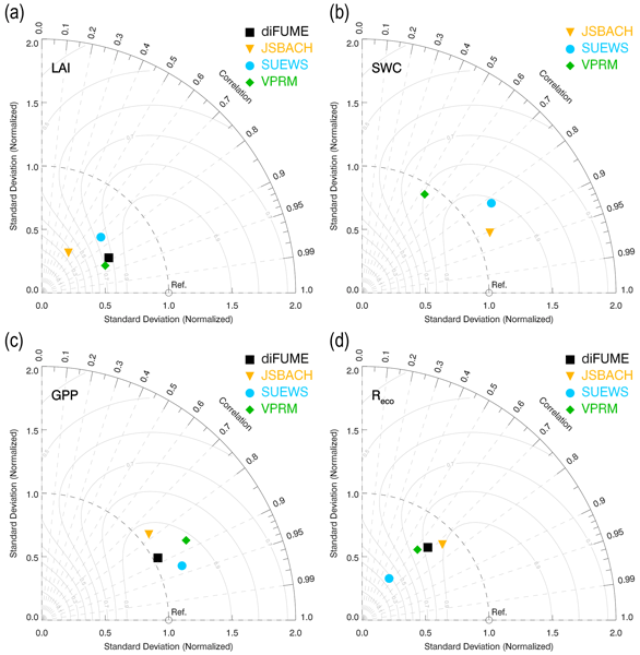
Stavros Stagakis, Dominik Brunner, Junwei Li, Leif Backman, Anni Karvonen, Lionel Constantin, Leena Järvi, Minttu Havu, Jia Chen, Sophie Emberger, and Liisa Kulmala
Biogeosciences, 22, 2133–2161, https://doi.org/10.5194/bg-22-2133-2025, https://doi.org/10.5194/bg-22-2133-2025, 2025
Short summary
Short summary
The balance between CO2 uptake and emissions from urban green areas is still not well understood. This study evaluated for the first time the urban park CO2 exchange simulations with four different types of biosphere model by comparing them with observations. Even though some advantages and disadvantages of the different model types were identified, there was no strong evidence that more complex models performed better than simple ones.
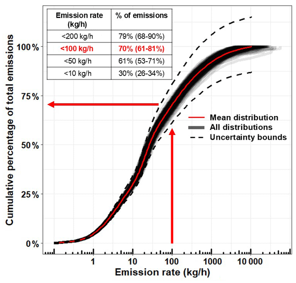
James P. Williams, Mark Omara, Anthony Himmelberger, Daniel Zavala-Araiza, Katlyn MacKay, Joshua Benmergui, Maryann Sargent, Steven C. Wofsy, Steven P. Hamburg, and Ritesh Gautam
Atmos. Chem. Phys., 25, 1513–1532, https://doi.org/10.5194/acp-25-1513-2025, https://doi.org/10.5194/acp-25-1513-2025, 2025
Short summary
Short summary
We utilize peer-reviewed facility-level oil and gas methane emission rate data gathered in prior work to estimate the relative contributions of methane sources emitting at different emission rates in the United States. We find that the majority of total methane emissions in the US oil and gas sector stem from a large number of small sources emitting in aggregate, corroborating findings from several other studies.
Neil Humpage, Hartmut Boesch, William Okello, Jia Chen, Florian Dietrich, Mark F. Lunt, Liang Feng, Paul I. Palmer, and Frank Hase
Atmos. Meas. Tech., 17, 5679–5707, https://doi.org/10.5194/amt-17-5679-2024, https://doi.org/10.5194/amt-17-5679-2024, 2024
Short summary
Short summary
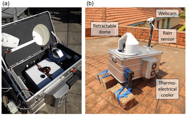
We used a Bruker EM27/SUN spectrometer within an automated weatherproof enclosure to measure greenhouse gas column concentrations over a 3-month period in Jinja, Uganda. The portability of the EM27/SUN allows us to evaluate satellite and model data in locations not covered by traditional validation networks. This is of particular value in tropical Africa, where extensive terrestrial ecosystems are a significant store of carbon and play a key role in the atmospheric budgets of CO2 and CH4.
Christopher Chan Miller, Sébastien Roche, Jonas S. Wilzewski, Xiong Liu, Kelly Chance, Amir H. Souri, Eamon Conway, Bingkun Luo, Jenna Samra, Jacob Hawthorne, Kang Sun, Carly Staebell, Apisada Chulakadabba, Maryann Sargent, Joshua S. Benmergui, Jonathan E. Franklin, Bruce C. Daube, Yang Li, Joshua L. Laughner, Bianca C. Baier, Ritesh Gautam, Mark Omara, and Steven C. Wofsy
Atmos. Meas. Tech., 17, 5429–5454, https://doi.org/10.5194/amt-17-5429-2024, https://doi.org/10.5194/amt-17-5429-2024, 2024
Short summary
Short summary
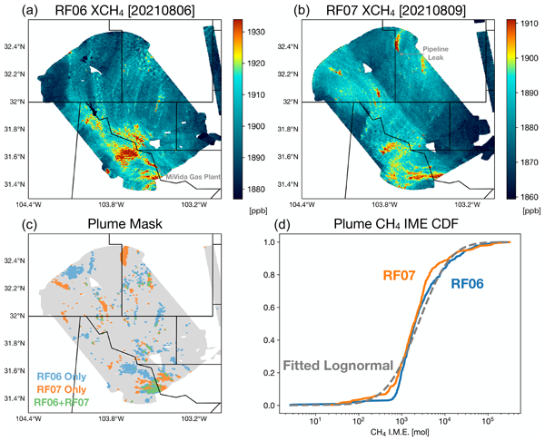
MethaneSAT is an upcoming satellite mission designed to monitor methane emissions from the oil and gas (O&G) industry globally. Here, we present observations from the first flight campaign of MethaneAIR, a MethaneSAT-like instrument mounted on an aircraft. MethaneAIR can map methane with high precision and accuracy over a typically sized oil and gas basin (~200 km2) in a single flight. This paper demonstrates the capability of the upcoming satellite to routinely track global O&G emissions.
Mark Omara, Anthony Himmelberger, Katlyn MacKay, James P. Williams, Joshua Benmergui, Maryann Sargent, Steven C. Wofsy, and Ritesh Gautam
Earth Syst. Sci. Data, 16, 3973–3991, https://doi.org/10.5194/essd-16-3973-2024, https://doi.org/10.5194/essd-16-3973-2024, 2024
Short summary
Short summary
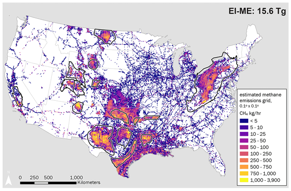
We review, analyze, and synthesize previous peer-reviewed measurement-based data on facility-level oil and gas methane emissions and use these data to develop a high-resolution spatially explicit inventory of US basin-level and national methane emissions. This work provides an improved assessment of national methane emissions relative to government inventories in support of accurate and comprehensive methane emissions assessment, attribution, and mitigation.
Zhendong Lu, Jun Wang, Yi Wang, Daven K. Henze, Xi Chen, Tong Sha, and Kang Sun
Atmos. Chem. Phys., 24, 7793–7813, https://doi.org/10.5194/acp-24-7793-2024, https://doi.org/10.5194/acp-24-7793-2024, 2024
Short summary
Short summary
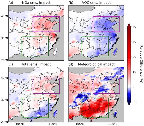
In contrast with past work showing that the reduction of emissions was the dominant factor for the nationwide increase of surface O3 during the lockdown in China, this study finds that the variation in meteorology (temperature and other parameters) plays a more important role. This result is obtained through sensitivity simulations using a chemical transport model constrained by satellite (TROPOMI) data and calibrated with surface observations.
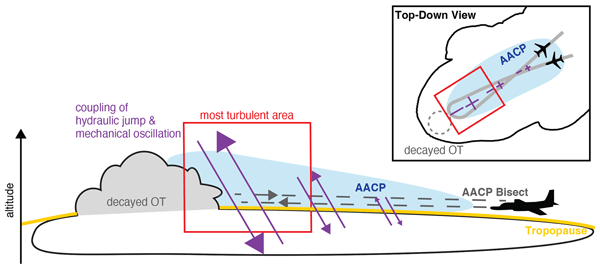
Andrea E. Gordon, Cameron R. Homeyer, Jessica B. Smith, Rei Ueyama, Jonathan M. Dean-Day, Elliot L. Atlas, Kate Smith, Jasna V. Pittman, David S. Sayres, David M. Wilmouth, Apoorva Pandey, Jason M. St. Clair, Thomas F. Hanisco, Jennifer Hare, Reem A. Hannun, Steven Wofsy, Bruce C. Daube, and Stephen Donnelly
Atmos. Chem. Phys., 24, 7591–7608, https://doi.org/10.5194/acp-24-7591-2024, https://doi.org/10.5194/acp-24-7591-2024, 2024
Short summary
Short summary
In situ airborne observations of ongoing tropopause-overshooting convection and an above-anvil cirrus plume from the 31 May 2022 flight of the Dynamics and Chemistry of the Summer Stratosphere (DCOTSS) field campaign are examined. Upper troposphere and lower stratosphere composition changes are evaluated along with possible contributing dynamical and physical processes. Measurements reveal multiple changes in air mass composition and stratospheric hydration throughout the flight.
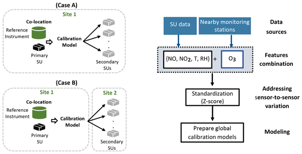
Ayah Abu-Hani, Jia Chen, Vigneshkumar Balamurugan, Adrian Wenzel, and Alessandro Bigi
Atmos. Meas. Tech., 17, 3917–3931, https://doi.org/10.5194/amt-17-3917-2024, https://doi.org/10.5194/amt-17-3917-2024, 2024
Short summary
Short summary
This study examined the transferability of machine learning calibration models among low-cost sensor units targeting NO2 and NO. The global models were evaluated under similar and different emission conditions. To counter cross-sensitivity, the study proposed integrating O3 measurements from nearby reference stations, in Switzerland. The models show substantial improvement when O3 measurements are incorporated, which is more pronounced when in regions with elevated O3 concentrations.
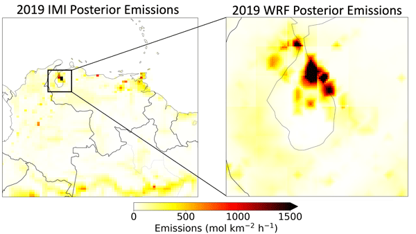
Brian Nathan, Joannes D. Maasakkers, Stijn Naus, Ritesh Gautam, Mark Omara, Daniel J. Varon, Melissa P. Sulprizio, Lucas A. Estrada, Alba Lorente, Tobias Borsdorff, Robert J. Parker, and Ilse Aben
Atmos. Chem. Phys., 24, 6845–6863, https://doi.org/10.5194/acp-24-6845-2024, https://doi.org/10.5194/acp-24-6845-2024, 2024
Short summary
Short summary
Venezuela's Lake Maracaibo region is notoriously hard to observe from space and features intensive oil exploitation, although production has strongly decreased in recent years. We estimate methane emissions using 2018–2020 TROPOMI satellite observations with national and regional transport models. Despite the production decrease, we find relatively constant emissions from Lake Maracaibo between 2018 and 2020, indicating that there could be large emissions from abandoned infrastructure.
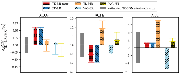
Benedikt Herkommer, Carlos Alberti, Paolo Castracane, Jia Chen, Angelika Dehn, Florian Dietrich, Nicholas M. Deutscher, Matthias Max Frey, Jochen Groß, Lawson Gillespie, Frank Hase, Isamu Morino, Nasrin Mostafavi Pak, Brittany Walker, and Debra Wunch
Atmos. Meas. Tech., 17, 3467–3494, https://doi.org/10.5194/amt-17-3467-2024, https://doi.org/10.5194/amt-17-3467-2024, 2024
Short summary
Short summary
The Total Carbon Column Observing Network is a network of ground-based Fourier transform infrared (FTIR) spectrometers used mainly for satellite validation. To ensure the highest-quality validation data, the network needs to be highly consistent. This is a major challenge, which so far is solved by site comparisons with airborne in situ measurements. In this work, we describe the use of a portable FTIR spectrometer as a travel standard for evaluating the consistency of TCCON sites.

Heesung Chong, Gonzalo González Abad, Caroline R. Nowlan, Christopher Chan Miller, Alfonso Saiz-Lopez, Rafael P. Fernandez, Hyeong-Ahn Kwon, Zolal Ayazpour, Huiqun Wang, Amir H. Souri, Xiong Liu, Kelly Chance, Ewan O'Sullivan, Jhoon Kim, Ja-Ho Koo, William R. Simpson, François Hendrick, Richard Querel, Glen Jaross, Colin Seftor, and Raid M. Suleiman
Atmos. Meas. Tech., 17, 2873–2916, https://doi.org/10.5194/amt-17-2873-2024, https://doi.org/10.5194/amt-17-2873-2024, 2024
Short summary
Short summary
We present a new bromine monoxide (BrO) product derived using radiances measured from OMPS-NM on board the Suomi-NPP satellite. This product provides nearly a decade of global stratospheric and tropospheric column retrievals, a feature that is currently rare in publicly accessible datasets. Both stratospheric and tropospheric columns from OMPS-NM demonstrate robust performance, exhibiting good agreement with ground-based observations collected at three stations (Lauder, Utqiagvik, and Harestua).
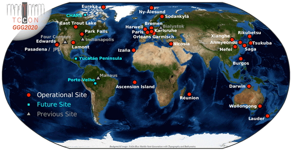
Joshua L. Laughner, Geoffrey C. Toon, Joseph Mendonca, Christof Petri, Sébastien Roche, Debra Wunch, Jean-Francois Blavier, David W. T. Griffith, Pauli Heikkinen, Ralph F. Keeling, Matthäus Kiel, Rigel Kivi, Coleen M. Roehl, Britton B. Stephens, Bianca C. Baier, Huilin Chen, Yonghoon Choi, Nicholas M. Deutscher, Joshua P. DiGangi, Jochen Gross, Benedikt Herkommer, Pascal Jeseck, Thomas Laemmel, Xin Lan, Erin McGee, Kathryn McKain, John Miller, Isamu Morino, Justus Notholt, Hirofumi Ohyama, David F. Pollard, Markus Rettinger, Haris Riris, Constantina Rousogenous, Mahesh Kumar Sha, Kei Shiomi, Kimberly Strong, Ralf Sussmann, Yao Té, Voltaire A. Velazco, Steven C. Wofsy, Minqiang Zhou, and Paul O. Wennberg
Earth Syst. Sci. Data, 16, 2197–2260, https://doi.org/10.5194/essd-16-2197-2024, https://doi.org/10.5194/essd-16-2197-2024, 2024
Short summary
Short summary
This paper describes a new version, called GGG2020, of a data set containing column-integrated observations of greenhouse and related gases (including CO2, CH4, CO, and N2O) made by ground stations located around the world. Compared to the previous version (GGG2014), improvements have been made toward site-to-site consistency. This data set plays a key role in validating space-based greenhouse gas observations and in understanding the carbon cycle.
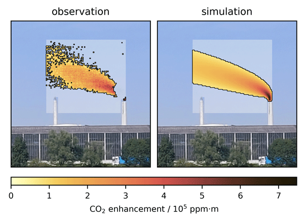
Marvin Knapp, Ralph Kleinschek, Sanam N. Vardag, Felix Külheim, Helge Haveresch, Moritz Sindram, Tim Siegel, Bruno Burger, and André Butz
Atmos. Meas. Tech., 17, 2257–2275, https://doi.org/10.5194/amt-17-2257-2024, https://doi.org/10.5194/amt-17-2257-2024, 2024
Short summary
Short summary
Imaging carbon dioxide (CO2) plumes of anthropogenic sources from planes and satellites has proven valuable for detecting emitters and monitoring climate mitigation efforts. We present the first images of CO2 plumes taken with a ground-based spectral camera, observing a coal-fired power plant as a validation target. We develop a technique to find the source emission strength with an hourly resolution, which reasonably agrees with the expected emissions under favorable conditions.
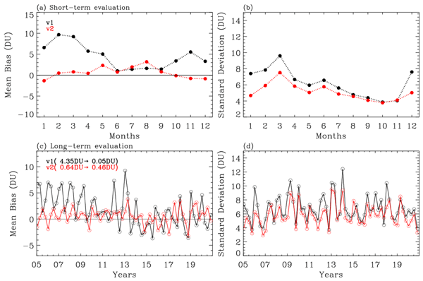
Juseon Bak, Xiong Liu, Kai Yang, Gonzalo Gonzalez Abad, Ewan O'Sullivan, Kelly Chance, and Cheol-Hee Kim
Atmos. Meas. Tech., 17, 1891–1911, https://doi.org/10.5194/amt-17-1891-2024, https://doi.org/10.5194/amt-17-1891-2024, 2024
Short summary
Short summary
The new version (V2) of the OMI ozone profile product is introduced to improve retrieval quality and long-term consistency of tropospheric ozone by incorporating the recent collection 4 OMI L1b spectral products and refining radiometric correction, forward model calculation, and a priori ozone data.
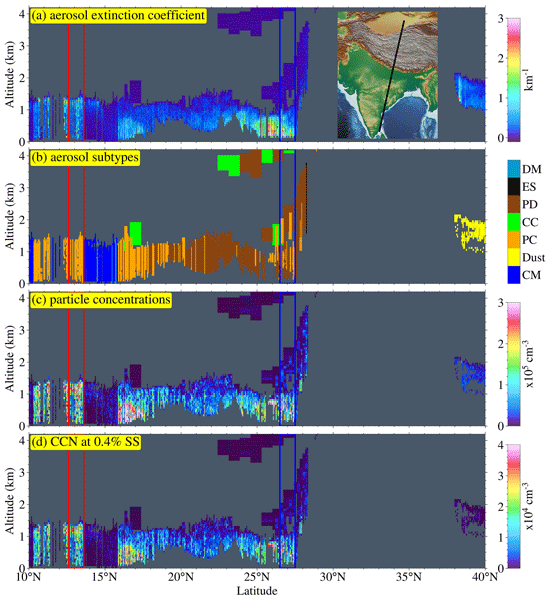
Piyushkumar N. Patel, Jonathan H. Jiang, Ritesh Gautam, Harish Gadhavi, Olga Kalashnikova, Michael J. Garay, Lan Gao, Feng Xu, and Ali Omar
Atmos. Chem. Phys., 24, 2861–2883, https://doi.org/10.5194/acp-24-2861-2024, https://doi.org/10.5194/acp-24-2861-2024, 2024
Short summary
Short summary
Global measurements of cloud condensation nuclei (CCN) are essential for understanding aerosol–cloud interactions and predicting climate change. To address this gap, we introduced a remote sensing algorithm that retrieves vertically resolved CCN number concentrations from airborne and spaceborne lidar systems. This innovation offers a global distribution of CCN concentrations from space, facilitating model evaluation and precise quantification of aerosol climate forcing.
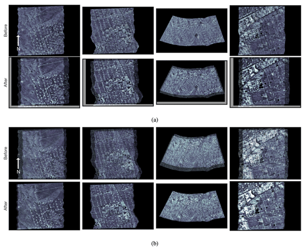
Eamon K. Conway, Amir H. Souri, Joshua Benmergui, Kang Sun, Xiong Liu, Carly Staebell, Christopher Chan Miller, Jonathan Franklin, Jenna Samra, Jonas Wilzewski, Sebastien Roche, Bingkun Luo, Apisada Chulakadabba, Maryann Sargent, Jacob Hohl, Bruce Daube, Iouli Gordon, Kelly Chance, and Steven Wofsy
Atmos. Meas. Tech., 17, 1347–1362, https://doi.org/10.5194/amt-17-1347-2024, https://doi.org/10.5194/amt-17-1347-2024, 2024
Short summary
Short summary
The work presented here describes the processes required to convert raw sensor data for the MethaneAIR instrument to geometrically calibrated data. Each algorithm is described in detail. MethaneAIR is the airborne simulator for MethaneSAT, a new satellite under development by MethaneSAT LLC, a subsidiary of the EDF. MethaneSAT's goals are to precisely map over 80 % of the production sources of methane emissions from oil and gas fields across the globe to a high degree of accuracy.
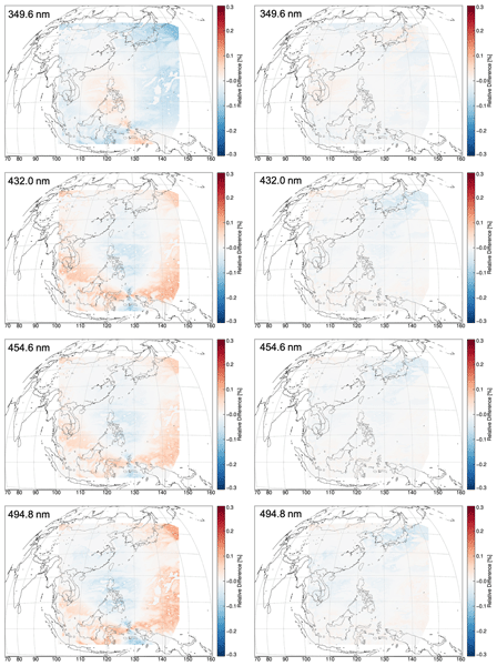
Haklim Choi, Xiong Liu, Ukkyo Jeong, Heesung Chong, Jhoon Kim, Myung Hwan Ahn, Dai Ho Ko, Dong-Won Lee, Kyung-Jung Moon, and Kwang-Mog Lee
Atmos. Meas. Tech., 17, 145–164, https://doi.org/10.5194/amt-17-145-2024, https://doi.org/10.5194/amt-17-145-2024, 2024
Short summary
Short summary
GEMS is the first geostationary satellite to measure the UV--Vis region, and this paper reports the polarization characteristics of GEMS and an algorithm. We develop a polarization correction algorithm optimized for GEMS based on a look-up-table approach that simultaneously considers the polarization of incoming light and polarization sensitivity characteristics of the instrument. Pre-launch polarization error was adjusted close to zero across the spectral range after polarization correction.
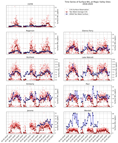
Karen E. Cady-Pereira, Xuehui Guo, Rui Wang, April B. Leytem, Chase Calkins, Elizabeth Berry, Kang Sun, Markus Müller, Armin Wisthaler, Vivienne H. Payne, Mark W. Shephard, Mark A. Zondlo, and Valentin Kantchev
Atmos. Meas. Tech., 17, 15–36, https://doi.org/10.5194/amt-17-15-2024, https://doi.org/10.5194/amt-17-15-2024, 2024
Short summary
Short summary
Ammonia is a significant precursor of PM2.5 particles and thus contributes to poor air quality in many regions. Furthermore, ammonia concentrations are rising due to the increase of large-scale, intensive agricultural activities. Here we evaluate satellite measurements of ammonia against aircraft and surface network data, and show that there are differences in magnitude, but the satellite data are spatially and temporally well correlated with the in situ data.
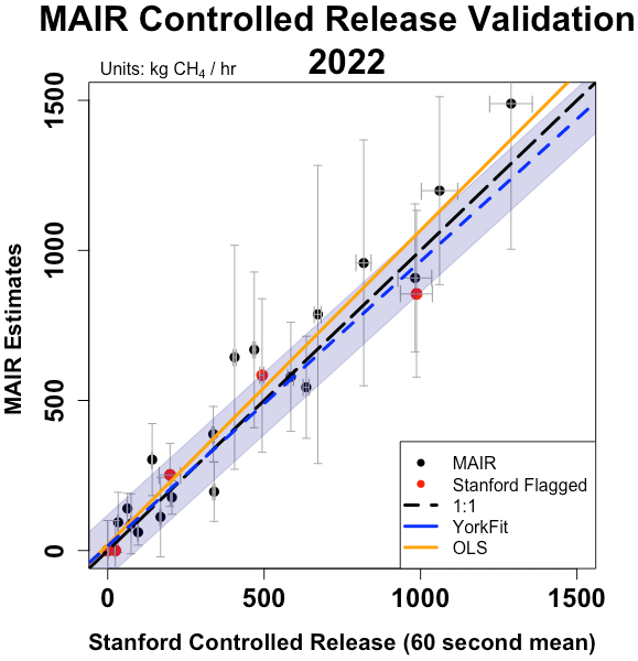
Apisada Chulakadabba, Maryann Sargent, Thomas Lauvaux, Joshua S. Benmergui, Jonathan E. Franklin, Christopher Chan Miller, Jonas S. Wilzewski, Sébastien Roche, Eamon Conway, Amir H. Souri, Kang Sun, Bingkun Luo, Jacob Hawthrone, Jenna Samra, Bruce C. Daube, Xiong Liu, Kelly Chance, Yang Li, Ritesh Gautam, Mark Omara, Jeff S. Rutherford, Evan D. Sherwin, Adam Brandt, and Steven C. Wofsy
Atmos. Meas. Tech., 16, 5771–5785, https://doi.org/10.5194/amt-16-5771-2023, https://doi.org/10.5194/amt-16-5771-2023, 2023
Short summary
Short summary
We show that MethaneAIR, a precursor to the MethaneSAT satellite, demonstrates accurate point source quantification during controlled release experiments and regional observations in 2021 and 2022. Results from our two independent quantification methods suggest the accuracy of our sensor and algorithms is better than 25 % for sources emitting 200 kg h−1 or more. Insights from these measurements help establish the capabilities of MethaneSAT and MethaneAIR.
Xinxu Zhao, Jia Chen, Julia Marshall, Michal Gałkowski, Stephan Hachinger, Florian Dietrich, Ankit Shekhar, Johannes Gensheimer, Adrian Wenzel, and Christoph Gerbig
Atmos. Chem. Phys., 23, 14325–14347, https://doi.org/10.5194/acp-23-14325-2023, https://doi.org/10.5194/acp-23-14325-2023, 2023
Short summary
Short summary
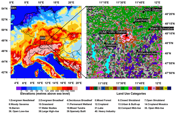
We develop a modeling framework using the Weather Research and Forecasting model at a high spatial resolution (up to 400 m) to simulate atmospheric transport of greenhouse gases and interpret column observations. Output is validated against weather stations and column measurements in August 2018. The differential column method is applied, aided by air-mass transport tracing with the Stochastic Time-Inverted Lagrangian Transport (STILT) model, also for an exploratory measurement interpretation.
Rui Zhu, Zhaojun Tang, Xiaokang Chen, Xiong Liu, and Zhe Jiang
Geosci. Model Dev., 16, 6337–6354, https://doi.org/10.5194/gmd-16-6337-2023, https://doi.org/10.5194/gmd-16-6337-2023, 2023
Short summary
Short summary
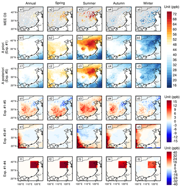
A single ozone (O3) tracer mode was developed in this work to build the capability of the GEOS-Chem model for rapid O3 simulation. It is combined with OMI and surface O3 observations to investigate the changes in tropospheric O3 in China in 2015–2020. The assimilations indicate rapid surface O3 increases that are underestimated by the a priori simulations. We find stronger increases in tropospheric O3 columns over polluted areas and a large discrepancy by assimilating different observations.
Rui Wang, Da Pan, Xuehui Guo, Kang Sun, Lieven Clarisse, Martin Van Damme, Pierre-François Coheur, Cathy Clerbaux, Melissa Puchalski, and Mark A. Zondlo
Atmos. Chem. Phys., 23, 13217–13234, https://doi.org/10.5194/acp-23-13217-2023, https://doi.org/10.5194/acp-23-13217-2023, 2023
Short summary
Short summary
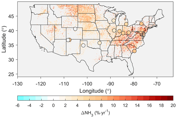
Ammonia (NH3) is a key precursor for fine particulate matter (PM2.5) and a primary form of reactive nitrogen, yet it has sparse ground measurements. We perform the first comprehensive comparison between ground observations and satellite retrievals in the US, demonstrating that satellite NH3 data can help fill spatial gaps in the current ground monitoring networks. Trend analyses using both datasets highlight increasing NH3 trends across the US, including the NH3 hotspots and urban areas.
Berend J. Schuit, Joannes D. Maasakkers, Pieter Bijl, Gourav Mahapatra, Anne-Wil van den Berg, Sudhanshu Pandey, Alba Lorente, Tobias Borsdorff, Sander Houweling, Daniel J. Varon, Jason McKeever, Dylan Jervis, Marianne Girard, Itziar Irakulis-Loitxate, Javier Gorroño, Luis Guanter, Daniel H. Cusworth, and Ilse Aben
Atmos. Chem. Phys., 23, 9071–9098, https://doi.org/10.5194/acp-23-9071-2023, https://doi.org/10.5194/acp-23-9071-2023, 2023
Short summary
Short summary
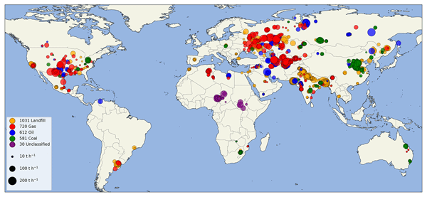
Using two machine learning models, which were trained on TROPOMI methane satellite data, we detect 2974 methane plumes, so-called super-emitters, in 2021. We detect methane emissions globally related to urban areas or landfills, coal mining, and oil and gas production. Using our monitoring system, we identify 94 regions with frequent emissions. For 12 locations, we target high-resolution satellite instruments to enlarge and identify the exact infrastructure responsible for the emissions.
Vigneshkumar Balamurugan, Jia Chen, Adrian Wenzel, and Frank N. Keutsch
Atmos. Chem. Phys., 23, 10267–10285, https://doi.org/10.5194/acp-23-10267-2023, https://doi.org/10.5194/acp-23-10267-2023, 2023
Short summary
Short summary
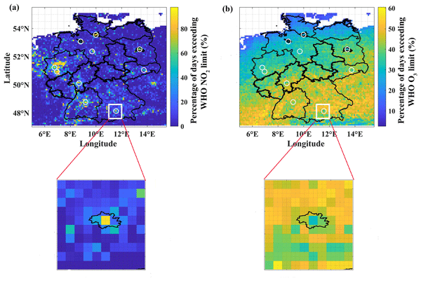
In this study, machine learning models are employed to model NO2 and O3 concentrations. We employed a wide range of sources of data, including meteorological and column satellite measurements, to model NO2 and O3 concentrations. The spatial and temporal variability, and their drivers, were investigated. Notably, the machine learning model established the relationship between NOx and O3. Despite the fact that metropolitan regions are NO2 hotspots, rural areas have high O3 concentrations.
Rui Zhu, Zhaojun Tang, Xiaokang Chen, Xiong Liu, and Zhe Jiang
Atmos. Chem. Phys., 23, 9745–9763, https://doi.org/10.5194/acp-23-9745-2023, https://doi.org/10.5194/acp-23-9745-2023, 2023
Short summary
Short summary
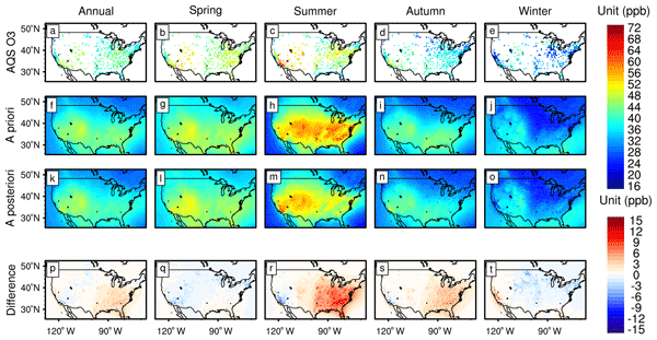
Ozone Monitoring Instrument (OMI) and surface O3 observations are used to investigate the changes in tropospheric O3 in the USA and Europe in 2005–2020. The surface-based assimilations show limited changes in surface and tropospheric column O3. The OMI-based assimilations show larger decreases in tropospheric O3 columns in 2010–2014, related to a decline in free-tropospheric NO2. Analysis suggests limited impacts of local emissions decline on tropospheric O3 over the USA and Europe in 2005–2020.
Mark Omara, Ritesh Gautam, Madeleine A. O'Brien, Anthony Himmelberger, Alex Franco, Kelsey Meisenhelder, Grace Hauser, David R. Lyon, Apisada Chulakadabba, Christopher Chan Miller, Jonathan Franklin, Steven C. Wofsy, and Steven P. Hamburg
Earth Syst. Sci. Data, 15, 3761–3790, https://doi.org/10.5194/essd-15-3761-2023, https://doi.org/10.5194/essd-15-3761-2023, 2023
Short summary
Short summary
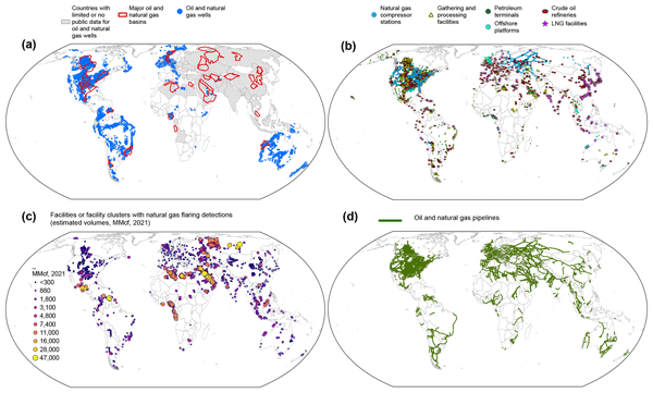
We acquire, integrate, and analyze ~ 6 million geospatial oil and gas infrastructure data records based on information available in the public domain and develop an open-access global database including all the major oil and gas facility types that are important sources of methane emissions. This work helps fulfill a crucial geospatial data need, in support of the assessment, attribution, and mitigation of global oil and gas methane emissions at high resolution.
Chantelle R. Lonsdale and Kang Sun
Atmos. Chem. Phys., 23, 8727–8748, https://doi.org/10.5194/acp-23-8727-2023, https://doi.org/10.5194/acp-23-8727-2023, 2023
Short summary
Short summary
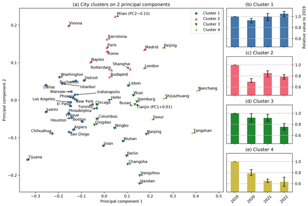
The COVID-19 pandemic, which was caused by the SARS-CoV-2 virus, emerged in 2019, and its still evolving variants have resulted in unprecedented shifts in human activities and anthropogenic emissions into the Earth's atmosphere. We present monthly nitrogen oxide emissions over three major continents from May 2018 to January 2023 to capture variations before and after the COVID-19 pandemic. We focus on a diverse collection of 54 cities to quantify the post-COVID-19 perturbations.
Shoma Yamanouchi, Stephanie Conway, Kimberly Strong, Orfeo Colebatch, Erik Lutsch, Sébastien Roche, Jeffrey Taylor, Cynthia H. Whaley, and Aldona Wiacek
Earth Syst. Sci. Data, 15, 3387–3418, https://doi.org/10.5194/essd-15-3387-2023, https://doi.org/10.5194/essd-15-3387-2023, 2023
Short summary
Short summary
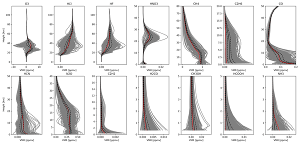
Nineteen years of atmospheric composition measurements made at the University of Toronto Atmospheric Observatory (TAO; 43.66° N, 79.40° W; 174 m.a.s.l.) are presented. These are retrieved from Fourier transform infrared (FTIR) solar absorption spectra recorded with a spectrometer from May 2002 to December 2020. The retrievals have been optimized for fourteen species: O3, HCl, HF, HNO3, CH4, C2H6, CO, HCN, N2O, C2H2, H2CO, CH3OH, HCOOH, and NH3.
Daniel J. Varon, Daniel J. Jacob, Benjamin Hmiel, Ritesh Gautam, David R. Lyon, Mark Omara, Melissa Sulprizio, Lu Shen, Drew Pendergrass, Hannah Nesser, Zhen Qu, Zachary R. Barkley, Natasha L. Miles, Scott J. Richardson, Kenneth J. Davis, Sudhanshu Pandey, Xiao Lu, Alba Lorente, Tobias Borsdorff, Joannes D. Maasakkers, and Ilse Aben
Atmos. Chem. Phys., 23, 7503–7520, https://doi.org/10.5194/acp-23-7503-2023, https://doi.org/10.5194/acp-23-7503-2023, 2023
Short summary
Short summary
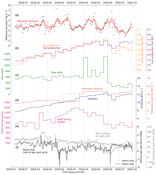
We use TROPOMI satellite observations to quantify weekly methane emissions from the US Permian oil and gas basin from May 2018 to October 2020. We find that Permian emissions are highly variable, with diverse economic and activity drivers. The most important drivers during our study period were new well development and natural gas price. Permian methane intensity averaged 4.6 % and decreased by 1 % per year.
James P. Williams, Khalil El Hachem, and Mary Kang
Atmos. Meas. Tech., 16, 3421–3435, https://doi.org/10.5194/amt-16-3421-2023, https://doi.org/10.5194/amt-16-3421-2023, 2023
Short summary
Short summary
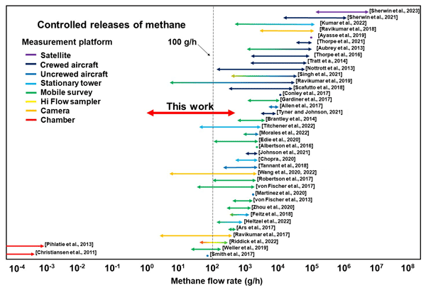
Methane is powerful greenhouse gas; thus, to reduce methane emissions, it is important that the methods used to measure methane are tested and validated. The static chamber method is an enclosure-based technique that directly measures methane emissions; however, it has not been thoroughly tested for the new variety of methane sources that it is currently being used for. We find that the static chamber method can accurately measure methane emissions under a wide range of methane emission rates.
Huiqun Wang, Gonzalo González Abad, Chris Chan Miller, Hyeong-Ahn Kwon, Caroline R. Nowlan, Zolal Ayazpour, Heesung Chong, Xiong Liu, Kelly Chance, Ewan O'Sullivan, Kang Sun, Robert Spurr, and Robert J. Hargreaves
Atmos. Meas. Tech. Discuss., https://doi.org/10.5194/amt-2023-66, https://doi.org/10.5194/amt-2023-66, 2023
Preprint withdrawn
Short summary
Short summary
A pipeline for retrieving Total Column Water Vapor from satellite blue spectra is developed. New constraints are considered. Water-leaving radiance is important over the oceans. Results agree with reference datasets well under clear conditions. Due to high sensitivity to clouds, strict data filtering criteria are required. All-sky retrievals can be corrected using machine learning. GPS stations’ representation errors follow a power law relationship with grid resolutions.
Andreas Forstmaier, Jia Chen, Florian Dietrich, Juan Bettinelli, Hossein Maazallahi, Carsten Schneider, Dominik Winkler, Xinxu Zhao, Taylor Jones, Carina van der Veen, Norman Wildmann, Moritz Makowski, Aydin Uzun, Friedrich Klappenbach, Hugo Denier van der Gon, Stefan Schwietzke, and Thomas Röckmann
Atmos. Chem. Phys., 23, 6897–6922, https://doi.org/10.5194/acp-23-6897-2023, https://doi.org/10.5194/acp-23-6897-2023, 2023
Short summary
Short summary
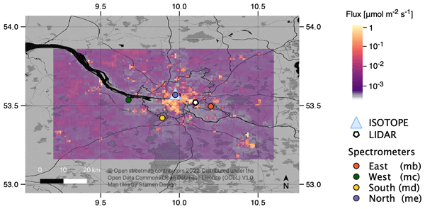
Large cities emit greenhouse gases which contribute to global warming. In this study, we measured the release of one important green house gas, methane, in Hamburg. Multiple sources that contribute to methane emissions were located and quantified. Methane sources were found to be mainly caused by human activity (e.g., by release from oil and gas refineries). Moreover, potential natural sources have been located, such as the Elbe River and lakes.
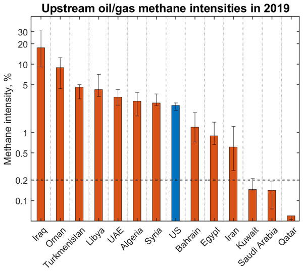
Zichong Chen, Daniel J. Jacob, Ritesh Gautam, Mark Omara, Robert N. Stavins, Robert C. Stowe, Hannah Nesser, Melissa P. Sulprizio, Alba Lorente, Daniel J. Varon, Xiao Lu, Lu Shen, Zhen Qu, Drew C. Pendergrass, and Sarah Hancock
Atmos. Chem. Phys., 23, 5945–5967, https://doi.org/10.5194/acp-23-5945-2023, https://doi.org/10.5194/acp-23-5945-2023, 2023
Short summary
Short summary
We quantify methane emissions from individual countries in the Middle East and North Africa by inverse analysis of 2019 TROPOMI satellite observations of atmospheric methane. We show that the ability to simply relate oil/gas emissions to activity metrics is compromised by stochastic nature of local infrastructure and management practices. We find that the industry target for oil/gas methane intensity is achievable through associated gas capture, modern infrastructure, and centralized operations.
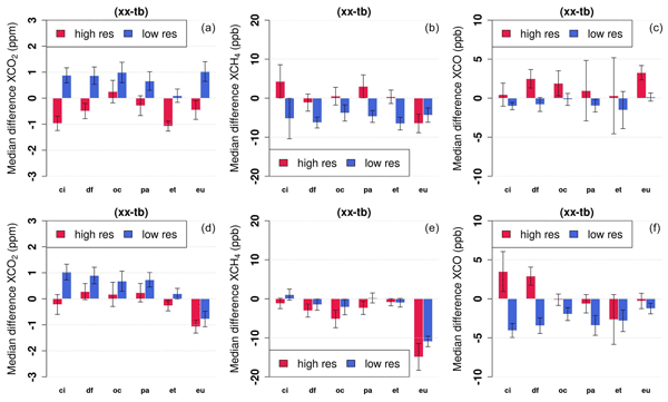
Nasrin Mostafavi Pak, Jacob K. Hedelius, Sébastien Roche, Liz Cunningham, Bianca Baier, Colm Sweeney, Coleen Roehl, Joshua Laughner, Geoffrey Toon, Paul Wennberg, Harrison Parker, Colin Arrowsmith, Joseph Mendonca, Pierre Fogal, Tyler Wizenberg, Beatriz Herrera, Kimberly Strong, Kaley A. Walker, Felix Vogel, and Debra Wunch
Atmos. Meas. Tech., 16, 1239–1261, https://doi.org/10.5194/amt-16-1239-2023, https://doi.org/10.5194/amt-16-1239-2023, 2023
Short summary
Short summary
Ground-based remote sensing instruments in the Total Carbon Column Observing Network (TCCON) measure greenhouse gases in the atmosphere. Consistency between TCCON measurements is crucial to accurately infer changes in atmospheric composition. We use portable remote sensing instruments (EM27/SUN) to evaluate biases between TCCON stations in North America. We also improve the retrievals of EM27/SUN instruments and evaluate the previous (GGG2014) and newest (GGG2020) retrieval algorithms.
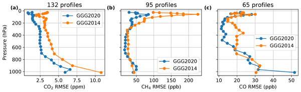
Joshua L. Laughner, Sébastien Roche, Matthäus Kiel, Geoffrey C. Toon, Debra Wunch, Bianca C. Baier, Sébastien Biraud, Huilin Chen, Rigel Kivi, Thomas Laemmel, Kathryn McKain, Pierre-Yves Quéhé, Constantina Rousogenous, Britton B. Stephens, Kaley Walker, and Paul O. Wennberg
Atmos. Meas. Tech., 16, 1121–1146, https://doi.org/10.5194/amt-16-1121-2023, https://doi.org/10.5194/amt-16-1121-2023, 2023
Short summary
Short summary
Observations using sunlight to measure surface-to-space total column of greenhouse gases in the atmosphere need an initial guess of the vertical distribution of those gases to start from. We have developed an approach to provide those initial guess profiles that uses readily available meteorological data as input. This lets us make these guesses without simulating them with a global model. The profiles generated this way match independent observations well.
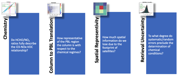
Amir H. Souri, Matthew S. Johnson, Glenn M. Wolfe, James H. Crawford, Alan Fried, Armin Wisthaler, William H. Brune, Donald R. Blake, Andrew J. Weinheimer, Tijl Verhoelst, Steven Compernolle, Gaia Pinardi, Corinne Vigouroux, Bavo Langerock, Sungyeon Choi, Lok Lamsal, Lei Zhu, Shuai Sun, Ronald C. Cohen, Kyung-Eun Min, Changmin Cho, Sajeev Philip, Xiong Liu, and Kelly Chance
Atmos. Chem. Phys., 23, 1963–1986, https://doi.org/10.5194/acp-23-1963-2023, https://doi.org/10.5194/acp-23-1963-2023, 2023
Short summary
Short summary
We have rigorously characterized different sources of error in satellite-based HCHO / NO2 tropospheric columns, a widely used metric for diagnosing near-surface ozone sensitivity. Specifically, the errors were categorized/quantified into (i) an inherent chemistry error, (ii) the decoupled relationship between columns and the near-surface concentration, (iii) the spatial representativeness error of ground satellite pixels, and (iv) the satellite retrieval errors.
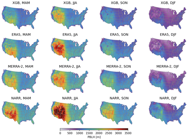
Zolal Ayazpour, Shiqi Tao, Dan Li, Amy Jo Scarino, Ralph E. Kuehn, and Kang Sun
Atmos. Meas. Tech., 16, 563–580, https://doi.org/10.5194/amt-16-563-2023, https://doi.org/10.5194/amt-16-563-2023, 2023
Short summary
Short summary
Accurate knowledge of the planetary boundary layer height (PBLH) is essential to study air pollution. However, PBLH observations are sparse in space and time, and PBLHs used in atmospheric models are often inaccurate. Using PBLH observations from the Aircraft Meteorological DAta Relay (AMDAR), we present a machine learning framework to produce a spatially complete PBLH product over the contiguous US that shows a better agreement with reference PBLH observations than commonly used PBLH products.
Hao Guo, Clare M. Flynn, Michael J. Prather, Sarah A. Strode, Stephen D. Steenrod, Louisa Emmons, Forrest Lacey, Jean-Francois Lamarque, Arlene M. Fiore, Gus Correa, Lee T. Murray, Glenn M. Wolfe, Jason M. St. Clair, Michelle Kim, John Crounse, Glenn Diskin, Joshua DiGangi, Bruce C. Daube, Roisin Commane, Kathryn McKain, Jeff Peischl, Thomas B. Ryerson, Chelsea Thompson, Thomas F. Hanisco, Donald Blake, Nicola J. Blake, Eric C. Apel, Rebecca S. Hornbrook, James W. Elkins, Eric J. Hintsa, Fred L. Moore, and Steven C. Wofsy
Atmos. Chem. Phys., 23, 99–117, https://doi.org/10.5194/acp-23-99-2023, https://doi.org/10.5194/acp-23-99-2023, 2023
Short summary
Short summary
We have prepared a unique and unusual result from the recent ATom aircraft mission: a measurement-based derivation of the production and loss rates of ozone and methane over the ocean basins. These are the key products of chemistry models used in assessments but have thus far lacked observational metrics. It also shows the scales of variability of atmospheric chemical rates and provides a major challenge to the atmospheric models.
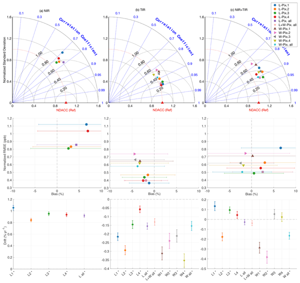
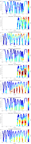
Ali Jalali, Kaley A. Walker, Kimberly Strong, Rebecca R. Buchholz, Merritt N. Deeter, Debra Wunch, Sébastien Roche, Tyler Wizenberg, Erik Lutsch, Erin McGee, Helen M. Worden, Pierre Fogal, and James R. Drummond
Atmos. Meas. Tech., 15, 6837–6863, https://doi.org/10.5194/amt-15-6837-2022, https://doi.org/10.5194/amt-15-6837-2022, 2022
Short summary
Short summary
This study validates MOPITT version 8 carbon monoxide measurements over the Canadian high Arctic for the period 2006 to 2019. The MOPITT products from different detector pixels and channels are compared with ground-based measurements from the Polar Environment Atmospheric Research Laboratory (PEARL) in Eureka, Nunavut, Canada. These results show good consistency between the satellite and ground-based measurements and provide guidance on the usage of these MOPITT data at high latitudes.
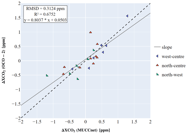
Maximilian Rißmann, Jia Chen, Gregory Osterman, Xinxu Zhao, Florian Dietrich, Moritz Makowski, Frank Hase, and Matthäus Kiel
Atmos. Meas. Tech., 15, 6605–6623, https://doi.org/10.5194/amt-15-6605-2022, https://doi.org/10.5194/amt-15-6605-2022, 2022
Short summary
Short summary
The Orbiting Carbon Observatory 2 (OCO-2) measures atmospheric concentrations of the most potent greenhouse gas, CO2, globally. By comparing its measurements to a ground-based monitoring network in Munich (MUCCnet), we find that the satellite is able to reliably detect urban CO2 concentrations. Furthermore, spatial CO2 differences captured by OCO-2 and MUCCnet are strongly correlated, which indicates that OCO-2 could be helpful in determining urban CO2 emissions from space.

Juseon Bak, Eun-Ji Song, Hyo-Jung Lee, Xiong Liu, Ja-Ho Koo, Joowan Kim, Wonbae Jeon, Jae-Hwan Kim, and Cheol-Hee Kim
Atmos. Chem. Phys., 22, 14177–14187, https://doi.org/10.5194/acp-22-14177-2022, https://doi.org/10.5194/acp-22-14177-2022, 2022
Short summary
Short summary
Our study investigates the temporal variations of ozone profiles at Pohang in the Korean Peninsula from multiple ozone products. We discuss the quantitative relationships between daily surface measurements and key meteorological variables, different seasonality of ozone between the troposphere and stratosphere, and interannual changes in the lower tropospheric ozone, linked by the weather pattern driven by the East Asian summer monsoon.
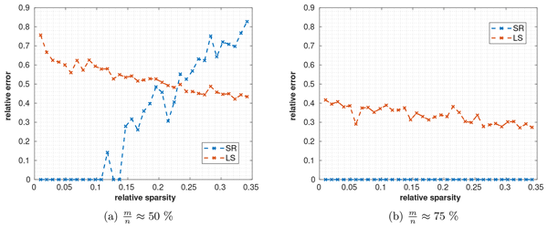
Benjamin Zanger, Jia Chen, Man Sun, and Florian Dietrich
Geosci. Model Dev., 15, 7533–7556, https://doi.org/10.5194/gmd-15-7533-2022, https://doi.org/10.5194/gmd-15-7533-2022, 2022
Short summary
Short summary
Gaussian priors (GPs) used in least squares inversion do not reflect the true distributions of greenhouse gas emissions well. A method that does not rely on GPs is sparse reconstruction (SR). We show that necessary conditions for SR are satisfied for cities and that the application of a wavelet transform can further enhance sparsity. We apply the theory of compressed sensing to SR. Our results show that SR needs fewer measurements and is superior for assessing unknown emitters compared to GPs.
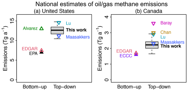
Lu Shen, Ritesh Gautam, Mark Omara, Daniel Zavala-Araiza, Joannes D. Maasakkers, Tia R. Scarpelli, Alba Lorente, David Lyon, Jianxiong Sheng, Daniel J. Varon, Hannah Nesser, Zhen Qu, Xiao Lu, Melissa P. Sulprizio, Steven P. Hamburg, and Daniel J. Jacob
Atmos. Chem. Phys., 22, 11203–11215, https://doi.org/10.5194/acp-22-11203-2022, https://doi.org/10.5194/acp-22-11203-2022, 2022
Short summary
Short summary
We use 22 months of TROPOMI satellite observations to quantity methane emissions from the oil (O) and natural gas (G) sector in the US and Canada at the scale of both individual basins as well as country-wide aggregates. We find that O/G-related methane emissions are underestimated in these inventories by 80 % for the US and 40 % for Canada, and 70 % of the underestimate in the US is from five O/G basins, including Permian, Haynesville, Anadarko, Eagle Ford, and Barnett.
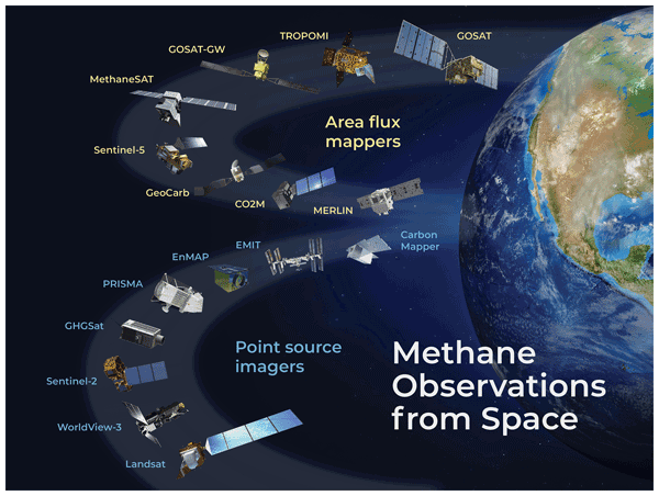
Daniel J. Jacob, Daniel J. Varon, Daniel H. Cusworth, Philip E. Dennison, Christian Frankenberg, Ritesh Gautam, Luis Guanter, John Kelley, Jason McKeever, Lesley E. Ott, Benjamin Poulter, Zhen Qu, Andrew K. Thorpe, John R. Worden, and Riley M. Duren
Atmos. Chem. Phys., 22, 9617–9646, https://doi.org/10.5194/acp-22-9617-2022, https://doi.org/10.5194/acp-22-9617-2022, 2022
Short summary
Short summary
We review the capability of satellite observations of atmospheric methane to quantify methane emissions on all scales. We cover retrieval methods, precision requirements, inverse methods for inferring emissions, source detection thresholds, and observations of system completeness. We show that current instruments already enable quantification of regional and national emissions including contributions from large point sources. Coverage and resolution will increase significantly in coming years.
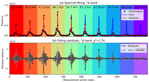
Kang Sun, Mahdi Yousefi, Christopher Chan Miller, Kelly Chance, Gonzalo González Abad, Iouli E. Gordon, Xiong Liu, Ewan O'Sullivan, Christopher E. Sioris, and Steven C. Wofsy
Atmos. Meas. Tech., 15, 3721–3745, https://doi.org/10.5194/amt-15-3721-2022, https://doi.org/10.5194/amt-15-3721-2022, 2022
Short summary
Short summary
This study of upper atmospheric airglow from oxygen is motivated by the need to measure oxygen simultaneously with methane and CO2 in satellite remote sensing. We provide an accurate understanding of the spatial, temporal, and spectral distribution of airglow emissions, which will help in the satellite remote sensing of greenhouse gases and constraining the chemical and physical processes in the upper atmosphere.
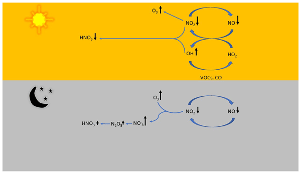
Vigneshkumar Balamurugan, Jia Chen, Zhen Qu, Xiao Bi, and Frank N. Keutsch
Atmos. Chem. Phys., 22, 7105–7129, https://doi.org/10.5194/acp-22-7105-2022, https://doi.org/10.5194/acp-22-7105-2022, 2022
Short summary
Short summary
In this study, we investigated the response of secondary pollutants to changes in precursor emissions, focusing on the formation of secondary PM, during the COVID-19 lockdown period. We show that, due to the decrease in primary NOx emissions, atmospheric oxidizing capacity is increased. The nighttime increase in ozone, caused by less NO titration, results in higher NO3 radicals, which contribute significantly to the formation of PM nitrates. O3 should be limited in order to control PM pollution.
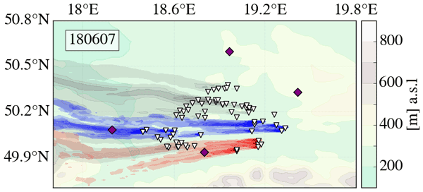
Andreas Luther, Julian Kostinek, Ralph Kleinschek, Sara Defratyka, Mila Stanisavljević, Andreas Forstmaier, Alexandru Dandocsi, Leon Scheidweiler, Darko Dubravica, Norman Wildmann, Frank Hase, Matthias M. Frey, Jia Chen, Florian Dietrich, Jarosław Nȩcki, Justyna Swolkień, Christoph Knote, Sanam N. Vardag, Anke Roiger, and André Butz
Atmos. Chem. Phys., 22, 5859–5876, https://doi.org/10.5194/acp-22-5859-2022, https://doi.org/10.5194/acp-22-5859-2022, 2022
Short summary
Short summary
Coal mining is an extensive source of anthropogenic methane emissions. In order to reduce and mitigate methane emissions, it is important to know how much and where the methane is emitted. We estimated coal mining methane emissions in Poland based on atmospheric methane measurements and particle dispersion modeling. In general, our emission estimates suggest higher emissions than expected by previous annual emission reports.
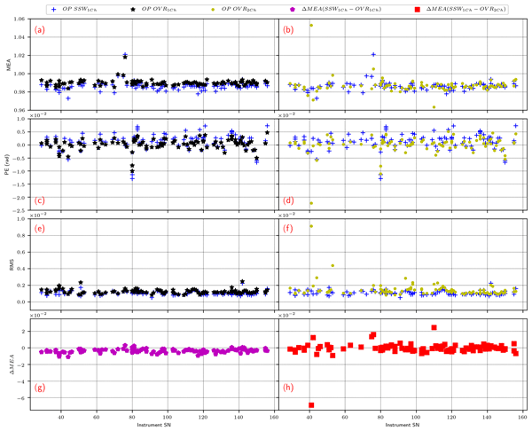
Carlos Alberti, Frank Hase, Matthias Frey, Darko Dubravica, Thomas Blumenstock, Angelika Dehn, Paolo Castracane, Gregor Surawicz, Roland Harig, Bianca C. Baier, Caroline Bès, Jianrong Bi, Hartmut Boesch, André Butz, Zhaonan Cai, Jia Chen, Sean M. Crowell, Nicholas M. Deutscher, Dragos Ene, Jonathan E. Franklin, Omaira García, David Griffith, Bruno Grouiez, Michel Grutter, Abdelhamid Hamdouni, Sander Houweling, Neil Humpage, Nicole Jacobs, Sujong Jeong, Lilian Joly, Nicholas B. Jones, Denis Jouglet, Rigel Kivi, Ralph Kleinschek, Morgan Lopez, Diogo J. Medeiros, Isamu Morino, Nasrin Mostafavipak, Astrid Müller, Hirofumi Ohyama, Paul I. Palmer, Mahesh Pathakoti, David F. Pollard, Uwe Raffalski, Michel Ramonet, Robbie Ramsay, Mahesh Kumar Sha, Kei Shiomi, William Simpson, Wolfgang Stremme, Youwen Sun, Hiroshi Tanimoto, Yao Té, Gizaw Mengistu Tsidu, Voltaire A. Velazco, Felix Vogel, Masataka Watanabe, Chong Wei, Debra Wunch, Marcia Yamasoe, Lu Zhang, and Johannes Orphal
Atmos. Meas. Tech., 15, 2433–2463, https://doi.org/10.5194/amt-15-2433-2022, https://doi.org/10.5194/amt-15-2433-2022, 2022
Short summary
Short summary
Space-borne greenhouse gas missions require ground-based validation networks capable of providing fiducial reference measurements. Here, considerable refinements of the calibration procedures for the COllaborative Carbon Column Observing Network (COCCON) are presented. Laboratory and solar side-by-side procedures for the characterization of the spectrometers have been refined and extended. Revised calibration factors for XCO2, XCO and XCH4 are provided, incorporating 47 new spectrometers.
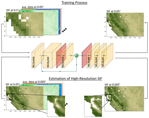
Johannes Gensheimer, Alexander J. Turner, Philipp Köhler, Christian Frankenberg, and Jia Chen
Biogeosciences, 19, 1777–1793, https://doi.org/10.5194/bg-19-1777-2022, https://doi.org/10.5194/bg-19-1777-2022, 2022
Short summary
Short summary
We develop a convolutional neural network, named SIFnet, that increases the spatial resolution of SIF from TROPOMI by a factor of 10 to a spatial resolution of 0.005°. SIFnet utilizes coarse SIF observations, together with a broad range of high-resolution auxiliary data. The insights gained from interpretable machine learning techniques allow us to make quantitative claims about the relationships between SIF and other common parameters related to photosynthesis.
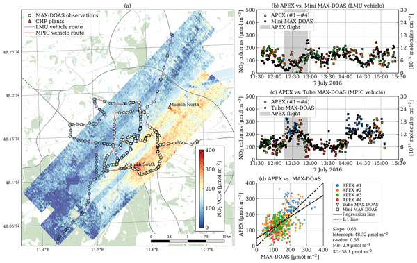
Gerrit Kuhlmann, Ka Lok Chan, Sebastian Donner, Ying Zhu, Marc Schwaerzel, Steffen Dörner, Jia Chen, Andreas Hueni, Duc Hai Nguyen, Alexander Damm, Annette Schütt, Florian Dietrich, Dominik Brunner, Cheng Liu, Brigitte Buchmann, Thomas Wagner, and Mark Wenig
Atmos. Meas. Tech., 15, 1609–1629, https://doi.org/10.5194/amt-15-1609-2022, https://doi.org/10.5194/amt-15-1609-2022, 2022
Short summary
Short summary
Nitrogen dioxide (NO2) is an air pollutant whose concentration often exceeds air quality guideline values, especially in urban areas. To map the spatial distribution of NO2 in Munich, we conducted the Munich NO2 Imaging Campaign (MuNIC), where NO2 was measured with stationary, mobile, and airborne in situ and remote sensing instruments. The campaign provides a unique dataset that has been used to compare the different instruments and to study the spatial variability of NO2 and its sources.
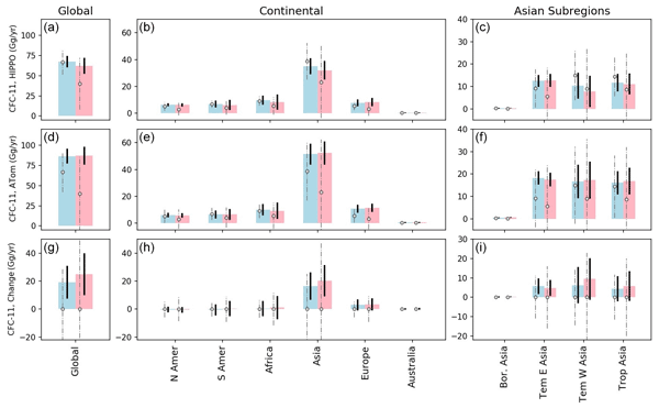
Lei Hu, Stephen A. Montzka, Fred Moore, Eric Hintsa, Geoff Dutton, M. Carolina Siso, Kirk Thoning, Robert W. Portmann, Kathryn McKain, Colm Sweeney, Isaac Vimont, David Nance, Bradley Hall, and Steven Wofsy
Atmos. Chem. Phys., 22, 2891–2907, https://doi.org/10.5194/acp-22-2891-2022, https://doi.org/10.5194/acp-22-2891-2022, 2022
Short summary
Short summary
The unexpected increase in CFC-11 emissions between 2012 and 2017 resulted in concerns about delaying the stratospheric ozone recovery. Although the subsequent decline of CFC-11 emissions indicated a mitigation in part to this problem, the regions fully responsible for these large emission changes were unclear. Here, our new estimate, based on atmospheric measurements from two global campaigns and from NOAA, suggests Asia primarily contributed to the global CFC-11 emission rise during 2012–2017.

Xiao Lu, Daniel J. Jacob, Haolin Wang, Joannes D. Maasakkers, Yuzhong Zhang, Tia R. Scarpelli, Lu Shen, Zhen Qu, Melissa P. Sulprizio, Hannah Nesser, A. Anthony Bloom, Shuang Ma, John R. Worden, Shaojia Fan, Robert J. Parker, Hartmut Boesch, Ritesh Gautam, Deborah Gordon, Michael D. Moran, Frances Reuland, Claudia A. Octaviano Villasana, and Arlyn Andrews
Atmos. Chem. Phys., 22, 395–418, https://doi.org/10.5194/acp-22-395-2022, https://doi.org/10.5194/acp-22-395-2022, 2022
Short summary
Short summary
We evaluate methane emissions and trends for 2010–2017 in the gridded national emission inventories for the United States, Canada, and Mexico by inversion of in situ and satellite methane observations. We find that anthropogenic methane emissions for all three countries are underestimated in the national inventories, largely driven by oil emissions. Anthropogenic methane emissions in the US peak in 2014, in contrast to the report of a steadily decreasing trend over 2010–2017 from the US EPA.
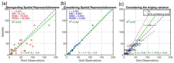
Amir H. Souri, Kelly Chance, Kang Sun, Xiong Liu, and Matthew S. Johnson
Atmos. Meas. Tech., 15, 41–59, https://doi.org/10.5194/amt-15-41-2022, https://doi.org/10.5194/amt-15-41-2022, 2022
Short summary
Short summary
The central component of satellite and model validation is pointwise measurements. A point is an element of space, whereas satellite (model) pixels represent an averaged area. These two datasets are inherently different. We leveraged some geostatistical tools to transform discrete points to gridded data with quantified uncertainty, comparable to satellite footprint (and response functions). This in part alleviated some complications concerning point–pixel comparisons.
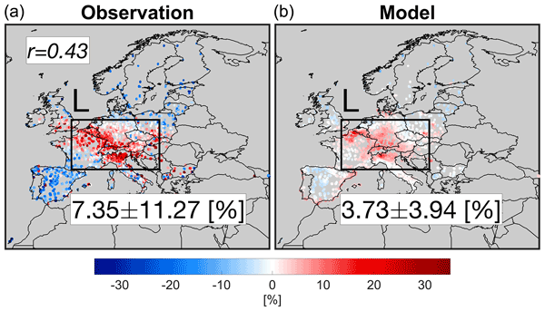
Amir H. Souri, Kelly Chance, Juseon Bak, Caroline R. Nowlan, Gonzalo González Abad, Yeonjin Jung, David C. Wong, Jingqiu Mao, and Xiong Liu
Atmos. Chem. Phys., 21, 18227–18245, https://doi.org/10.5194/acp-21-18227-2021, https://doi.org/10.5194/acp-21-18227-2021, 2021
Short summary
Short summary
The global pandemic is believed to have an impact on emissions of air pollutants such as nitrogen dioxide (NO2) and formaldehyde (HCHO). This study quantifies the changes in the amount of NOx and VOC emissions via state-of-the-art inverse modeling technique using satellite observations during the lockdown 2020 with respect to a baseline over Europe, which in turn, it permits unraveling atmospheric processes being responsible for ozone formation in a less cloudy month.
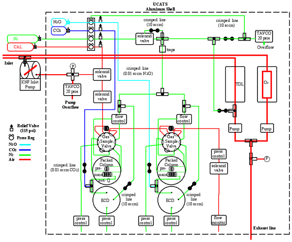
Eric J. Hintsa, Fred L. Moore, Dale F. Hurst, Geoff S. Dutton, Bradley D. Hall, J. David Nance, Ben R. Miller, Stephen A. Montzka, Laura P. Wolton, Audra McClure-Begley, James W. Elkins, Emrys G. Hall, Allen F. Jordan, Andrew W. Rollins, Troy D. Thornberry, Laurel A. Watts, Chelsea R. Thompson, Jeff Peischl, Ilann Bourgeois, Thomas B. Ryerson, Bruce C. Daube, Yenny Gonzalez Ramos, Roisin Commane, Gregory W. Santoni, Jasna V. Pittman, Steven C. Wofsy, Eric Kort, Glenn S. Diskin, and T. Paul Bui
Atmos. Meas. Tech., 14, 6795–6819, https://doi.org/10.5194/amt-14-6795-2021, https://doi.org/10.5194/amt-14-6795-2021, 2021
Short summary
Short summary
We built UCATS to study atmospheric chemistry and transport. It has measured trace gases including CFCs, N2O, SF6, CH4, CO, and H2 with gas chromatography, as well as ozone and water vapor. UCATS has been part of missions to study the tropical tropopause; transport of air into the stratosphere; greenhouse gases, transport, and chemistry in the troposphere; and ozone chemistry, on both piloted and unmanned aircraft. Its design, capabilities, and some results are shown and described here.
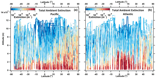
Charles A. Brock, Karl D. Froyd, Maximilian Dollner, Christina J. Williamson, Gregory Schill, Daniel M. Murphy, Nicholas J. Wagner, Agnieszka Kupc, Jose L. Jimenez, Pedro Campuzano-Jost, Benjamin A. Nault, Jason C. Schroder, Douglas A. Day, Derek J. Price, Bernadett Weinzierl, Joshua P. Schwarz, Joseph M. Katich, Siyuan Wang, Linghan Zeng, Rodney Weber, Jack Dibb, Eric Scheuer, Glenn S. Diskin, Joshua P. DiGangi, ThaoPaul Bui, Jonathan M. Dean-Day, Chelsea R. Thompson, Jeff Peischl, Thomas B. Ryerson, Ilann Bourgeois, Bruce C. Daube, Róisín Commane, and Steven C. Wofsy
Atmos. Chem. Phys., 21, 15023–15063, https://doi.org/10.5194/acp-21-15023-2021, https://doi.org/10.5194/acp-21-15023-2021, 2021
Short summary
Short summary
The Atmospheric Tomography Mission was an airborne study that mapped the chemical composition of the remote atmosphere. From this, we developed a comprehensive description of aerosol properties that provides a unique, global-scale dataset against which models can be compared. The data show the polluted nature of the remote atmosphere in the Northern Hemisphere and quantify the contributions of sea salt, dust, soot, biomass burning particles, and pollution particles to the haziness of the sky.
Cited articles
Canny, J.: A Computational Approach to Edge Detection, IEEE T. Pattern Anal., PAMI-8, 679–698, https://doi.org/10.1109/TPAMI.1986.4767851, 1986. a
Chan Miller, C., Roche, S., Wilzewski, J. S., Liu, X., Chance, K., Souri, A. H., Conway, E., Luo, B., Samra, J., Hawthorne, J., Sun, K., Staebell, C., Chulakadabba, A., Sargent, M., Benmergui, J. S., Franklin, J. E., Daube, B. C., Li, Y., Laughner, J. L., Baier, B. C., Gautam, R., Omara, M., and Wofsy, S. C.: Methane retrieval from MethaneAIR using the CO2 proxy approach: a demonstration for the upcoming MethaneSAT mission, Atmos. Meas. Tech., 17, 5429–5454, https://doi.org/10.5194/amt-17-5429-2024, 2024. a, b
Chulakadabba, A., Sargent, M., Lauvaux, T., Benmergui, J. S., Franklin, J. E., Chan Miller, C., Wilzewski, J. S., Roche, S., Conway, E., Souri, A. H., Sun, K., Luo, B., Hawthrone, J., Samra, J., Daube, B. C., Liu, X., Chance, K., Li, Y., Gautam, R., Omara, M., Rutherford, J. S., Sherwin, E. D., Brandt, A., and Wofsy, S. C.: Methane point source quantification using MethaneAIR: a new airborne imaging spectrometer, Atmos. Meas. Tech., 16, 5771–5785, https://doi.org/10.5194/amt-16-5771-2023, 2023. a, b, c, d, e
Cusworth, D. H., Jacob, D. J., Varon, D. J., Chan Miller, C., Liu, X., Chance, K., Thorpe, A. K., Duren, R. M., Miller, C. E., Thompson, D. R., Frankenberg, C., Guanter, L., and Randles, C. A.: Potential of next-generation imaging spectrometers to detect and quantify methane point sources from space, Atmos. Meas. Tech., 12, 5655–5668, https://doi.org/10.5194/amt-12-5655-2019, 2019. a
Donoho, D. L. and Johnstone, I. M.: Minimax estimation via wavelet shrinkage, Ann. Stat., 26, 879–921, https://doi.org/10.1214/aos/1024691081, 1998. a
Duren, R., Cusworth, D., Ayasse, A., Howell, K., Diamond, A., Scarpelli, T., Kim, J., O'neill, K., Lai-Norling, J., Thorpe, A., Zandbergen, S. R., Shaw, L., Keremedjiev, M., Guido, J., Giuliano, P., Goldstein, M., Nallapu, R., Barentsen, G., Thompson, D. R., Roth, K., Jensen, D., Eastwood, M., Reuland, F., Adams, T., Brandt, A., Kort, E. A., Mason, J., and Green, R. O.: The Carbon Mapper emissions monitoring system, Atmos. Meas. Tech., 18, 6933–6958, https://doi.org/10.5194/amt-18-6933-2025, 2025. a
Duren, R. M., Thorpe, A. K., Foster, K. T., Rafiq, T., Hopkins, F. M., Yadav, V., Bue, B. D., Thompson, D. R., Conley, S., Colombi, N. K., Frankenberg, C., McCubbin, I. B., Eastwood, M. L., Falk, M., Herner, J. D., Croes, B. E., Green, R. O., and Miller, C. E.: California’s methane super-emitters, Nature, 575, 180–184, https://doi.org/10.1038/s41586-019-1720-3, 2019. a, b
Ehret, T., De Truchis, A., Mazzolini, M., Morel, J.-M., D’aspremont, A., Lauvaux, T., Duren, R., Cusworth, D., and Facciolo, G.: Global tracking and quantification of oil and gas methane emissions from recurrent Sentinel-2 imagery, Environ. Sci. Technol., 56, 10517–10529, https://doi.org/10.1021/acs.est.1c08575, 2022. a
El Abbadi, S. H., Chen, Z., Burdeau, P. M., Rutherford, J. S., Chen, Y., Zhang, Z., Sherwin, E. D., and Brandt, A. R.: Technological Maturity of Aircraft-Based Methane Sensing for Greenhouse Gas Mitigation, Environ. Sci. Technol., 58, 9591–9600, https://doi.org/10.1021/acs.est.4c02439, 2024. a
Guanter, L., Kaufmann, H., Segl, K., Foerster, S., Rogass, C., Chabrillat, S., Kuester, T., Hollstein, A., Rossner, G., Chlebek, C., Straif, C., Fischer, S., Schrader, S., Storch, T., Heiden, U., Mueller, A., Bachmann, M., Mühle, H., Müller, R., Habermeyer, M., Ohndorf, A., Hill, J., Buddenbaum, H., Hostert, P., Van der Linden, S., Leitão, P. J., Rabe, A., Doerffer, R., Krasemann, H., Xi, H., Mauser, W., Hank, T., Locherer, M., Rast, M., Staenz, K., and Sang, B.: The EnMAP spaceborne imaging spectroscopy mission for earth observation, Remote Sensing, 7, 8830–8857, https://doi.org/10.3390/rs70708830, 2015. a
Guanter, L., Irakulis-Loitxate, I., Gorroño, J., Sánchez-García, E., Cusworth, D. H., Varon, D. J., Cogliati, S., and Colombo, R.: Mapping methane point emissions with the PRISMA spaceborne imaging spectrometer, Remote Sens. Environ., 265, 112671, https://doi.org/10.1016/j.rse.2021.112671, 2021. a
Guanter, L., Warren, J., Omara, M., Chulakadabba, A., Roger, J., Sargent, M., Franklin, J. E., Wofsy, S. C., and Gautam, R.: Detection and quantification of methane plumes with the MethaneAIR airborne spectrometer, Atmos. Meas. Tech., 18, 3857–3872, https://doi.org/10.5194/amt-18-3857-2025, 2025. a, b
Guanter, L., Roger, J., Warren, J., Sargent, M., Zhang, Z., Roche, S., Miller, C. C., Steiner, M., Hadfield, H., Omara, M., Williams, J., MacKay, K., Franklin, J. E., Luo, B., Wofsy, S. C., Hamburg, S. P., and Gautam, R.: Surveying methane point-source super-emissions across oil and gas basins with MethaneSAT, Atmos. Chem. Phys., 26, 2941–2963, https://doi.org/10.5194/acp-26-2941-2026, 2026. a, b
He, T.-L., Boyd, R. J., Varon, D. J., and Turner, A. J.: Increased methane emissions from oil and gas following the Soviet Union's collapse, P. Natl. Acad. Sci. USA, 121, e2314600121, https://doi.org/10.1073/pnas.2314600121, 2024. a
Jacob, D. J., Turner, A. J., Maasakkers, J. D., Sheng, J., Sun, K., Liu, X., Chance, K., Aben, I., McKeever, J., and Frankenberg, C.: Satellite observations of atmospheric methane and their value for quantifying methane emissions, Atmos. Chem. Phys., 16, 14371–14396, https://doi.org/10.5194/acp-16-14371-2016, 2016. a
Jacob, D. J., Varon, D. J., Cusworth, D. H., Dennison, P. E., Frankenberg, C., Gautam, R., Guanter, L., Kelley, J., McKeever, J., Ott, L. E., Poulter, B., Qu, Z., Thorpe, A. K., Worden, J. R., and Duren, R. M.: Quantifying methane emissions from the global scale down to point sources using satellite observations of atmospheric methane, Atmos. Chem. Phys., 22, 9617–9646, https://doi.org/10.5194/acp-22-9617-2022, 2022. a
Jongaramrungruang, S., Thorpe, A. K., Matheou, G., and Frankenberg, C.: MethaNet – An AI-driven approach to quantifying methane point-source emission from high-resolution 2-D plume imagery, Remote Sens. Environment, 269, 112809, https://doi.org/10.1016/j.rse.2021.112809, 2022. a
Kuhlmann, G., Koene, E., Meier, S., Santaren, D., Broquet, G., Chevallier, F., Hakkarainen, J., Nurmela, J., Amorós, L., Tamminen, J., and Brunner, D.: The ddeq Python library for point source quantification from remote sensing images (version 1.0), Geosci. Model Dev., 17, 4773–4789, https://doi.org/10.5194/gmd-17-4773-2024, 2024. a
Mallat, S. G.: Wavelet Bases, in: A Wavelet Tour of Signal Processing, Academic Press, 220–320, https://doi.org/10.1016/B978-012466606-1/50009-X, 1999. a
anninen, E., Chulakadabba, A., Sargent, M., Zhang, Z., Kamdar, H., Warren, J., Roche, S., Chan Miller, C., Kyzivat, E., Benmergui, J., Pittman, J., Walker, E., Bushey, J., Samra, J., Hawthorne, J., Luo, B., Nasr, M., Sun, K., Franklin, J., Liu, X., Chen, J., and Wofsy, S.: Probabilities of Detection of Methane Plumes by Remote Sensing and Implications for Inferred Emissions Distributions, EGUsphere [preprint], https://doi.org/10.5194/egusphere-2026-115, 2026. a, b, c, d
Omara, M., Gautam, R., O'Brien, M. A., Himmelberger, A., Franco, A., Meisenhelder, K., Hauser, G., Lyon, D. R., Chulakadabba, A., Miller, C. C., Franklin, J., Wofsy, S. C., and Hamburg, S. P.: Developing a spatially explicit global oil and gas infrastructure database for characterizing methane emission sources at high resolution, Earth Syst. Sci. Data, 15, 3761–3790, https://doi.org/10.5194/essd-15-3761-2023, 2023. a
Radman, A., Mahdianpari, M., Varon, D. J., and Mohammadimanesh, F.: S2MetNet: A novel dataset and deep learning benchmark for methane point source quantification using Sentinel-2 satellite imagery, Remote Sens. Environ., 295, 113708, https://doi.org/10.1016/j.rse.2023.113708, 2023. a
Rasti, B., Ulfarsson, M. O., and Ghamisi, P.: Automatic Hyperspectral Image Restoration Using Sparse and Low-Rank Modeling, IEEE Geosci. Remote S., 14, 2335–2339, https://doi.org/10.1109/LGRS.2017.2764059, 2017. a
Rasti, B., Scheunders, P., Ghamisi, P., Licciardi, G., and Chanussot, J.: Noise Reduction in Hyperspectral Imagery: Overview and Application, Remote Sensing, 10, https://doi.org/10.3390/rs10030482, 2018. a
Rouet-Leduc, B. and Hulbert, C.: Automatic detection of methane emissions in multispectral satellite imagery using a vision transformer, Nat. Commun., 15, 3801, https://doi.org/10.1038/s41467-024-47754-y, 2024. a
Sánchez-García, E., Gorroño, J., Irakulis-Loitxate, I., Varon, D. J., and Guanter, L.: Mapping methane plumes at very high spatial resolution with the WorldView-3 satellite, Atmos. Meas. Tech., 15, 1657–1674, https://doi.org/10.5194/amt-15-1657-2022, 2022. a, b, c
Scafutto, R. D. P. M. and De Souza Filho, C. R.: Detection of methane plumes using airborne midwave infrared (3–5 µm) hyperspectral data, Remote Sensing, 10, https://doi.org/10.3390/rs10081237, 2018. a
Schneising, O., Buchwitz, M., Hachmeister, J., Vanselow, S., Reuter, M., Buschmann, M., Bovensmann, H., and Burrows, J. P.: Advances in retrieving XCH4 and XCO from Sentinel-5 Precursor: improvements in the scientific TROPOMI/WFMD algorithm, Atmos. Meas. Tech., 16, 669–694, https://doi.org/10.5194/amt-16-669-2023, 2023. a
Růžička, V., Mateo-Garcia, G., Gómez-Chova, L., Vaughan, A., Guanter, L., and Markham, A.: Semantic segmentation of methane plumes with hyperspectral machine learning models, Scientific Reports, 13, 19999, https://doi.org/10.1038/s41598-023-44918-6, 2023. a, b
Thompson, D. R., Leifer, I., Bovensmann, H., Eastwood, M., Fladeland, M., Frankenberg, C., Gerilowski, K., Green, R. O., Kratwurst, S., Krings, T., Luna, B., and Thorpe, A. K.: Real-time remote detection and measurement for airborne imaging spectroscopy: a case study with methane, Atmos. Meas. Tech., 8, 4383–4397, https://doi.org/10.5194/amt-8-4383-2015, 2015. a
Thorpe, A. K., Green, R. O., Thompson, D. R., Brodrick, P. G., Chapman, J. W., Elder, C. D., Irakulis-Loitxate, I., Cusworth, D. H., Ayasse, A. K., Duren, R. M., Frankenberg, C., Guanter, L., Worden, J. R., Dennison, P. E., Roberts, D. A., Chadwick, K. D., Eastwood, M. L., Fahlen, J. E., and Miller, C. E.: Attribution of individual methane and carbon dioxide emission sources using EMIT observations from space, Science Advances, 9, eadh2391, https://doi.org/10.1126/sciadv.adh2391, 2023. a
UNEP-IMEO: Methane Alert and Response System (MARS), https://www.unep.org/explore-topics/energy/what-we-do/methane/imeo-action/methane-alert-and-response-system-mars (last access: 23 April 2026), 2023. a
Varon, D. J., Jacob, D. J., McKeever, J., Jervis, D., Durak, B. O. A., Xia, Y., and Huang, Y.: Quantifying methane point sources from fine-scale satellite observations of atmospheric methane plumes, Atmos. Meas. Tech., 11, 5673–5686, https://doi.org/10.5194/amt-11-5673-2018, 2018. a, b
Warren, J. D., Sargent, M., Williams, J. P., Omara, M., Miller, C. C., Roche, S., MacKay, K., Manninen, E., Chulakadabba, A., Himmelberger, A., Benmergui, J., Zhang, Z., Guanter, L., Wofsy, S., and Gautam, R.: Sectoral contributions of high-emitting methane point sources from major US onshore oil and gas producing basins using airborne measurements from MethaneAIR, Atmos. Chem. Phys., 25, 10661–10675, https://doi.org/10.5194/acp-25-10661-2025, 2025. a, b, c, d, e, f, g, h
Williams, J. P., Benmergui, J., Knapp, M., Omara, M., Himmelberger, A., Kyzivat, E., Weatherby, K., Lyke, B., Warren, J., MacKay, K., Ayvazov, S., Russi, M., LoFaso, N., Melendez, T., Miller, C. C., Roche, S., Sargent, M., Franklin, J., Nasr, M., Zhang, Z., Miller, D. J., Luo, B., Guanter, L., Hamburg, S. P., Wofsy, S. C., and Gautam, R.: Methane intensity and emissions across major oil and gas basins and individual jurisdictions using MethaneSAT observations, Atmos. Chem. Phys., 26, 5961–5981, https://doi.org/10.5194/acp-26-5961-2026, 2026. a
Xiao, C., Fu, B., Shui, H., Guo, Z., and Zhu, J.: Detecting the sources of methane emission from oil shale mining and processing using airborne hyperspectral data, Remote Sensing, 12, https://doi.org/10.3390/rs12030537, 2020. a
Zanger, B., Chen, J., Sun, M., and Dietrich, F.: Recovery of sparse urban greenhouse gas emissions, Geosci. Model Dev., 15, 7533–7556, https://doi.org/10.5194/gmd-15-7533-2022, 2022. a
Zhang, Z.: zhanzhangqq/wavelet_plume_finder_public: License Update: Added MIT License (Version v1.0.1), Zenodo [computer software], https://doi.org/10.5281/zenodo.21286248, 2026. a
Short summary
Methane released into the atmosphere is often difficult to detect in satellite imagery because the signals can be weak and hidden by background noise. We developed an automated method that improves the visibility of methane plumes while reducing false detections, decreasing the need for time-consuming manual inspection. The method identifies more small emission sources across different instruments, helping build a more complete understanding of methane emissions and their impacts.
Methane released into the atmosphere is often difficult to detect in satellite imagery because...


